|
How to use GPS track files!
What is a Track File?
A track file is a list of sequential coordinates that's created as a GPS
unit moves along with the bike. Each line in the file is a point in 3-D space, containing
latitude, longitude, and (usually) time and elevation. Depending on the bike's speed, and the turns
of the trail, the points may be close together (separated by a couple of feet)
or widely spaced (200-300 feet).
What is a Track File good for?
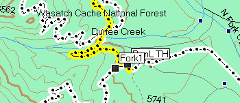
If you have a track file for a specific trail, your GPS unit can display it
on the map of the area. As you ride along, the little marker that says "I
am here" moves along the line of track points. If the little arrow moves
away from the line, you just took a wrong turn. With a track file, you just
follow the line, and you're retracing the path the original rider took.
Even on the most complex trail system, you can't get lost.
How is a Track File created?
You turn your GPS unit on, clear out any previous data points, then ride the
trail. As you reach the end of the trail, you save the track data to a file
within the GPS unit, or you download the active track to your computer.
Are Track Files a perfect representation of a trail's layout?
No. On some trails, for example Bear Canyon in the south fork of American Fork
Canyon, the slope of the mountain is too steep and the trees are too thick. For
over a mile, there's no satellite reception. Sometimes, for reasons of its own,
the GPS unit suddenly plots a point that's waaaay off the trail. And often, the
GPS track just jumps right across from Point A to Point C, bypassing a curve or
corner. But, within these limitations, the track file will fit pretty well as
you ride, and should keep you on the right path.
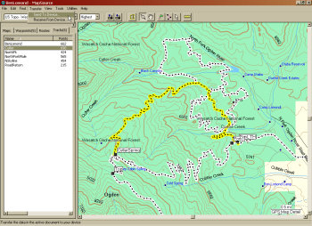
How do I use somebody else's Track File?
If you don't ride with a GPS unit, you can still benefit from track data. It
allows creation of a very accurate map (but only as accurate as the data in the
track file). Once a track file is created by the GPS
unit, it can be uploaded to a computer. The line created by the track file can
be shown on a satellite photo or a topographical map by many types of free
software, for example Google Earth. This trail map can be used by another rider
to follow the trail. A rider can load the track file into his GPS unit and follow the
track line, just as if his own GPS had created the track.
Is there a standard "Track File" format?
Unfortunately, no. Almost every GPS manufacturer uses a different format for
storing and transferring track data. So you need a middleman -- a program on
your computer that can import a downloaded track file from the UMB web site,
then export that data to your GPS unit. "GPX" is the most easily
convertible format. GPX files are written in XML language. But the GPX output
files of different GPS units may vary, for example by including heart rate or
storing the data for each track point in a different order.
What do I need to BUY to use Track Files?
You need a GPS unit, with a cord that connects it to your computer, and you
need a program on your computer that can process GPX files. First, install the
"middleman" program on your computer. Examples include Garmin
Mapsource, National Geographic TOPO, and Topofusion. (The Topofusion demo
version is free.) Now connect your GPS unit to the computer, and make sure they
can talk to each other.
How do I create maps?
Download a track file from this web site. Open the file with your map-creation
software, for example National Geographic, Topofusion, or Google Earth. You should see an
outline of the trail. Select the type of background you want (relief, shading,
detail, resolution, space photo vs topographic background, etc). Select the area
you want to print as a map. Include nearby roads if you want. Fiddle until
you've got the biggest, highest-resolution map possible. Now send it to your
printer.
How can I get a Track File into my GPS unit?
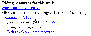 |
Download a track file from this
web site, by going to the "Riding Resources" section at the bottom of
the trail's web page.
Right-click over the file type you want. (If you try to download
directly, your computer may simply display the XML code of the GPS file
inside a browser window. Or it may open it with some other program that
uses XML coding. So right-click. Right-click! |
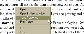 |
Did you remember you were supposed to right-click on the GPS
file link?
When the dialog box pops up, select the option that saves the file to
your computer without opening it. |
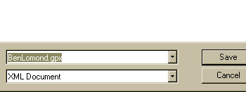 |
When the "Save" dialog box opens, browse to the
directory where you keep your GPS track files. Save the file.
If you want, rename the file. Ignore any XML warnings or offers to
convert -- a GPS track file is written in XML language, and it's ready to
use as-is. |
 |
The file is now on your computer, where you can access it
any time.
Ready to transfer the ride data to your GPS unit?
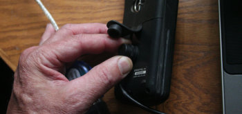
Plug your GPS unit into the computer transfer cable that came with it. |
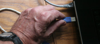 |
And plug the other end into the computer.
Turn the GPS unit on. |
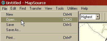 |
Now launch your GPS software.
Use your GPS software to open the track file you downloaded. |
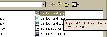 |
Did you remember to save the file in the GPS software's
default directory?
If the program won't open, use a GPS conversion utility to change the
track file's XML coding to a type that your program can recognize. These
utilities can be downloaded for free. |
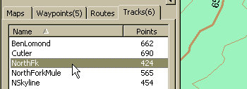 |
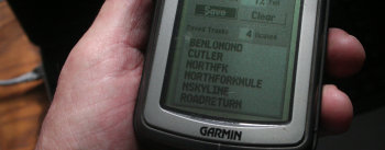
If there are several tracks in the GPS file, decide whether
you want the ALL the tracks in your unit. A single track corresponding to
your planned ride is less confusing. More tracks gives you options for
add-on rides and alternate routes. |
 |
Zoom in on the critical forks and get an idea of the layout
of the land. It helps to add your own Waypoints with comments, to make
navigation easier when you start riding.
You can also use the GPX file in Google Earth to do a virtual fly-over
of the trail. |
 |
You can combine different track files to see multiple rides
in the area, and to be aware of alternate routes.
Download GPS files from nearby rides and combine them. Build your store
of information about the area.
If your GPS unit doesn't display maps, this pre-ride look at the
terrain, roads, alternate trails, and landmarks will help you stay on the
right path. |
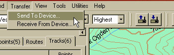 |
Now export your GPS information from the computer to your
GPS unit. Click the icon (photo right), or select the menu option (photo
left). |
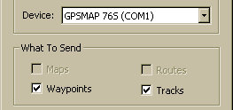 |
Make sure the configuration and transfer options are
correct. |
 |
The tracks are now in the memory of your GPS unit. Depending
on the capabilities of your unit, you can pull up information about the
track or display the track on top of an area map. |
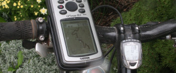 |
When you begin your ride, follow the saved track on your
display. Most units automatically show saved tracks in bold lines. Others
require that you select the track for "backtrack" or navigation.
Some units will alert you if you've gotten off-track.
No, we can't teach you how to use your own GPS unit. |
How do I "convert" a track file?
Most of the time, your software will open a GPX-format file without a problem.
If your GPS unit doesn't use specific data that's contained in the file, it will
usually ignore that data. But it may ask you if you want to convert the file. Go
ahead. If you can't open the GPX version of the track file from this site, find
a conversion utility. The conversion utility will translate the file from basic
GPX to an alternate format. These utilities can be downloaded, free, from
multiple sites. Just do a web search for "GPX conversion utility"
adding your GPS unit brand's name.
So where do I get these track files?
UtahMountainBiking.com has track files for almost all of the rides described on this site. You'll find the download link on the trail's page. (Go to the trails index, find the trail you want,
and click on the link to that page.) The link to the GPS track is usually near the bottom of the page,
along with options for other trail resources. If you don't see the track file
there, try our forum, where there's a section for sharing GPS data. Remember to right-click the link and select "save
as..." If your computer intercepts with a stupid message such as "Open
as XML" or "Convert to..." just ignore the message and save the
file. (Your OS learns to associate certain files with specific
programs. For example a RTF file may be automatically opened by MS Word -- and
converted to Word-specific format -- even though it was created with WordPad. The
GPX format is a form of XML language. Your computer knows this, and it's
trying to confuse you by making things more complicated than they need to be.
Just save the file as-is, then open it with your GPS software.)
Got a good track file for a trail?
Send it to us as an email attachment! [Email
Link]
|


