 |
Bonneville Shoreline Trail
Draper
Section,
Including Oak Hollow and Spring Hollow Trails
Seeming surprisingly "isolated" for a trail so close to civilization, the Bonneville
Shoreline Trail (BST) on Draper's south mountain is a worthwhile ride. This section is
5.5 miles in length, from Coyote Hollow to the end near the Flight Park. The Shoreline itself has only 200 feet of absolute
elevation change, but up-and-down riding yields about 600 feet of
climbing. It's intermediate in technical requirement.
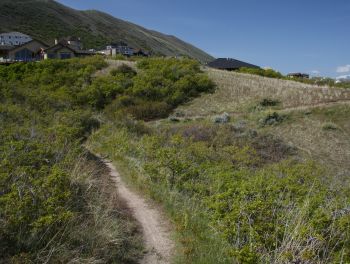
View east on the Shoreline Trail. The
track is fairly narrow, with steep sideslopes. First review and photos by Bruce
May 10, 2006.
Updated information September 2016. |
| The eastern end of this section of the BST begins at Coyote
Hollow in Corner Canyon. Arbitrarily, we'll
start the trail discussion at the eastern end, riding east to west. From the trailhead it's about 100 feet to connect to the BST. Downhill
and east takes you on the Corner Canyon BST
section. Uphill (a right turn) takes you on the westbound BST.
Climb 1/10th mile up to the T intersection. Here Clark's
Trail is on the left, climbing up to Ann's
Trail near the Peak View trailhead on Traverse Ridge. Fork to the
right on the BST.
Climbing up from the Coyote Hollow trailhead, back
when the trail was freshly cut. Big thick maples and oak. |

|
 |
The trail must climb up and around the homes south of the
Draper Temple. So your climb will continue on a gradual incline as you
skirt a small valley. You'll gain about 150 vertical feet over the next
half mile.
Once you're above the homes, you'll reach your first connection
opportunity, Potato Hill. This trail climbs 0.5 miles to
Ann's Trail for
loop rides, or 0.7 to the Potato Hill trailhead on Traverse Mountain road.
The loop combining Ann's Trail and the BST is tough but popular.
Keep
level and right to stay on the BST.
Alex, coming from the west, approaches the Potato
Hill trail fork on the BST. Photo May 2014. |
| After getting past the "castles on the hill," the
BST can descend again. You'll coast through a set of long switchbacks on a
gentle 100-foot vertical descent, then resume a rolling ride westbound.
About 0.9 miles after the Potato Hill fork, you'll pass the second half
of the Potato Hill circuit, Red Potato. This trail also connects to the
Potato Hill trailhead, 0.7 miles uphill.
Alex drops down Red Potato toward the BST. |

|
 |
Now you'll skirt the Red Rock area, about 1/4 mile west
from the Red Potato trail fork. Here a trail comes up to the BST from the Red Rock trailhead parking on Mike
Weir Drive. This connector downhill (on your right) is only about 200 feet
long.
The trail that goes uphill on your left is for
foot-traffic only. You're welcome to lean the bike against a tree (off the
trail please) and walk uphill to see what that's all about.
To get to the Spring Hollow Trail, you'll need to go down
the connector to the Red Rock parking area. Make a hard right turn as
you drop into the trailhead, then pedal all the way to the far east end of the parking lot. Go
across the bridge, then -- watching carefully -- dodge the traffic in the
crosswalk to get over to Spring Hollow.
Looking at Red Rock from the west. |
| Spring Hollow is narrow and occasionally technical due to
gambel oak roots. Unless it's seen some TLC, I'd rank it as
upper-intermediate. Spring Hollow skirts the golf course as it descends.
The trail ends on Vestry Drive 0.8 miles downhill -- without further
singletrack connections. (Note that the Oak Hollow trail starts on Vestry
Drive to the west.)
We're descending the Spring Hollow
Trail. There's some open area like this, as the trail flirts with a few
greens of the golf course. There's also forested riding. |

|
 |
After a short distance of traverse from Red Rock, the BST
descends and crosses Mike Weir Drive at a crosswalk. Now that you're on
the downhill side of the road, the trail rolls and winds around small
drainages. Some areas get a little loose with cobble -- old river rock
from Lake Bonneville.
Alex swoops along on the BST. |
| 0.8 miles after crossing the paved Mike Wier road, the trail
approaches the Traverse Mountain Road. As you near the trail underpass,
the Oak Hollow trail forks to the right. Oak Hollow descends 0.8
miles to the Draper Pool area.
An excellent short loop ride is to park at the Draper Pool
(Vestry Drive, just east of the roundabout) and climb Oak Hollow. Go left
on the BST instead of tunneling under the road. Drop off the Shoreline at
the Mike Weir trailhead to go downhill on Spring Hollow. Now take Vestry
back to where you parked. (Note: when you reach
Vestry Drive on Spring Hollow, you can either jog right 50 feet to find the trail downhill to
Highland Drive, or turn left on Vestry to head back to the pool. If you jog over to find the continuing trail, it takes you down
a fenced chute between several back yards, then connects with the sidewalk
along Highland Drive.)
We're climbing up the Oak Hollow Trail
toward the BST. Despite traversing an area thick with homes, the connector
trails feel private and isolated. |

|
 |
To continue a westbound BST ride, turn to the left at the
Oak Hollow fork and go under Traverse Mountain Road. Cross the dry creek
and climb north back to a shoulder above the road. Here you'll reach the
fork for Ann's Trail.
At the BST-Oak Hollow trail fork, the westbound uphill trail will take
you up to the Oak Hollow trailhead along Traverse Ridge Road.
Pedaling Oak Hollow.
|
| Ann's Trail, sometimes called the Draper Rim, climbs high on
the mountain and circles back to the east. After 700 vertical feet, you can take
Ann's Connector to
Eagle Crest, or continue east to Potato Hill
or the Peak View trailhead (the
top of Rush and Clark's).
To continue with the BST, keep to the right and head west.
View of Timpanogos and the mountains east of Alpine,
seen over the ridge from Ann's Trail. You can see the trail's course at
mid-mountain on the left of the photo. |

|
 |
From the Ann's Trail intersection, the BST will continue another 2.2
miles along the side of the mountain. This area can be more narrow and
technical because it sees less traffic, and usually less maintenance. But
don't skip this part, because it's a scenic and fun ride -- plenty of
miles without too much work.
Oak Hollow, Pool to Tunnel: 0.8 miles
Tunnel to flight park: 2.6 miles
Connector Oak Hollow to Mike Weir: 0.9 miles
Mike Weir crossing to Mike Weir trailhead: 0.5 miles
Mike Weir trailhead to east end: 0.9 miles
Spring Hollow, Weir to Vestry: 0.8 miles
Vestry to Pool: 1 mile
Looking west towards the Oquirrh
Mountains. We've heading west toward the
gliding park. |
Getting there: To start at the Draper Pool,
leave I-15 at the Bluffdale exit and go east. Just after climbing the long
hill, you'll come to a light. Go straight, then take the next right turn
at Vestry Drive in 0.5 mile. Roll around the roundabout to go left, then
turn into the pool parking. To start the ride, head back to the roundabout
and find the trail on the uphill-southwest side.
Red Rock (Mike Weir) trailhead: Leave I-15 and climb the hill as above,
but turn right at the light on Traverse Mountain Road. After one mile,
turn left onto Mike Weir Drive. The trailhead parking is on your right,
1/2 mile later.
Coyote Hollow trailhead: Take the Bluffdale exit from I-15 and turn
east towards the mountains. Climb the hill as above, but turn right at the
light on Traverse Mountain Road. After one mile, turn into Mike Weir Drive
on your left. Pass the Mike Weir trailhead 1/2 mile later and continue
another half mile until the road veers left downhill. Take the next right
turn, turn right again, then left. You should now be on Gray Fox Drive.
Take the next right into Coyote Hollow Court. The parking is on the right
at the end of the pavement.
Oak Hollow (Traverse Ridge Road) trailhead: On Traverse Ridge
Road, about a mile uphill from Highland Drive, turn into the fenced
parking area on the north (downhill) side of the road. The connector to
Oak Hollow and to the BST is at the eastern end of the parking area. Drop
about 1/10th mile down the singletrack and you'll reach the BST and the
Oak Hollow trail at the underpass. |
|


