 |
Big Bad Brutal Baldy Loop
Grove Creek to Dry Canyon
This loop ride is for strong, skilled, advanced riders only. It
features a long and very steep climb, a mean tricky descent, and plenty of
opportunities to hurt yourself. The trail surface is often rough and
loose. It's a tough trip both uphill and down. You'll need good climbing
skills (or a tolerance for long hike-a-bikes) and a sense of adventure. The ride is 15 miles, going from 5160
feet to 8280 feet. Total climbing will be about 3500 feet. And because of
rough trail conditions, that 3500 of climbing is harder than it sounds.
Looking uphill on the Grove Creek
trail. For much of the uphill, the trail hugs a ledge between cliffs. Lots
of little rocks to make your back tire slip...
Spin out and tip the wrong way -- you're magpie food.
Photos July 4, 2006.
|
| Most riders don't have the taste for pain required to climb
uphill on Grove Creek. It is a brutal climb. The trail is most commonly done as a downhill. For information on riding Grove Creek as a shuttled
downhill, see the Grove Creek Trail page. |
|
The loop ride starts at the edge of Pleasant Grove, at the mouth
of Grove Creek Canyon. The first little bit is pleasant, as you ride
through the trees along the river. Then you start climbing on narrow trail
with lots of loose rock. You'll switchback to the left away from the
creek, then switchback to the right to head back east. At the corner of
this second switchback, the Mahogany Mountain
trail forks northbound on your left.
The trail rises high above the creek, hugging the
mountainside along the cliffs. This is a tough granny-gear climb, made
harder by loose rock rolling and slipping under the tires. Not easy. I
suggest frequent breaks to catch your breath, so you can attack with a
high-cadence pedal stroke to keep up your speed over the loose trail
surface.
Grove Creek Falls is about two miles up the trail. Nice spot for a break here.
Shortly after the falls, the trail crosses the creek and climbs
switchbacks, then crosses back to the original side of the creek as it reaches
the shoulder of the mountain.
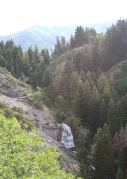
View of Grove Creek Falls, with
Timpanogos in the background. The white spots at mid-left are hikers on
the trail. |
|
 |
Here the climbing continues, but it's more mellow. You're
riding in quaking aspens and meadows. There are a few springs that create
swampy areas on the trail.
When you reach the Indian camp and pass the last set of springs from
which Grove Creek originates, you'll turn right at a fork.
(Straight ahead takes you to Timpooneke Road.)
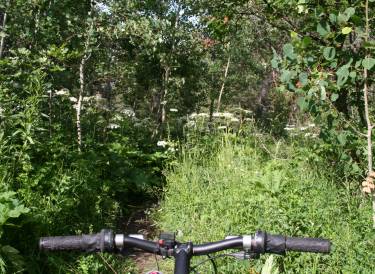
Handlebar view of the Grove Creek
Trail just before the Indian Camp. |
| When you reach doubletrack, you can go left a mile to a
viewpoint looking over the valley. Right takes you to the Battle Creek
Trail, which starts as doubletrack then becomes narrow singletrack as it
descends. Somewhere here, the Battle Creek Trail forks right,
but I didn't see the fork. If you see a trail fork here, keep left. Just stay on the main trail heading towards the
pass behind Baldy.
I wouldn't want you to think this
trail is all sweat, pain, and danger. There's also stinging nettle, like
this shoulder-high crop. Just hold your breath, tuck your elbows in, and
ride as straight as you can.
|

|
 |
After losing a bit of hard-won elevation, you begin climbing
the switchbacks to the pass. The grade here is OK, but there are many
sections that are strewn with huge loose boulders. I couldn't ride it
clean. The turns of the switchbacks
tend to be torn up and loose from horse traffic, with some trenching and
washouts. (Note 2011: The winter's heavy runoff created further damage.
This part of the trail is reported to be ugly.)
We're almost at the end of the Grove
Creek Trail, where will join the Battle Creek Trail. The track here is
about 8 inches wide. |
| At the pass behind Big Baldy, the trail crosses over the
ridge. There's a connection to the Great Western
Trail just below the pass, heading to your left. Depending on the season,
it may be overgrown with tall grass and hard to spot. The GWT takes
you down to the Orem Bench Trail in Provo Canyon. This is a
MUCH easier descent than Dry Canyon, but it adds several miles to the
loop. Most riders, as I was, are stupid enough to plunge down toward Dry
Canyon.
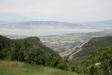
Looking west over Utah Lake as we
climb the switchbacks towards Big Baldy. |
|
 |
The Dry Canyon trail rapidly becomes a deep steep trench.
It's a hairy, white-knuckle, uncontrolled descent. And if you walk, you'll
probably slip and fall down anyway. Horses tear up the surface of this
deep "ditch" of a trail, so there's little for your tread to
grab as you slide headlong down the mountain. Get your butt back over the
rear tire. Work your brakes intelligently. But you ain't gonna stop, dude,
so just surf on down. If you need to bail, step off the back of the bike.
It's not pretty.
Looking up the side of Timpanogos from
the pass. |
| When the pitch of the Dry Canyon Trail becomes more sane,
there are still big rocks to contend with. You need good bike-handling
skills here, but the trail actually becomes fun to ride again.
The trail ends in a series of steps above the Dry
Canyon Trailhead. From here, turn right and find the Bonneville Shoreline
Trail to ride north.
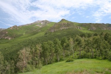
Looking south, that's Provo peak on
the left as we begin our scary descent into Dry Canyon. |

|
Riding notes, clockwise loop:
0.0 From parking lot, head east up the canyon
N 40° 22.483 W 111° 42.721
0.5 Switchback, go L uphill toward valley.
Ignore small trail going straight.
0.9 Trail turns R toward canyon.
At fork, keep R (L=Mahogany Mtn)
N 40° 22.751 W 111° 42.575
2.3 Bridge, cross creek, climb.
N 40° 23.414 W 111° 41.734
3.4 Indian Camp / Springs, fork R
N 40° 23.690 W 111° 41.174
4.0 L on DT toward Timpooneke Road |
4.1 R on DT, N 40° 23.226 W
111° 41.069
Keep heading generally
southeast
7.3 Cross pass, plunge downhill
N 40° 22.295 W 111° 39.354
10.6 Dry Canyon Trailhead, go R to ST at gate
N 40° 20.522 W 111° 40.564
13.3 BST dumps onto gravel road, go N
N 40° 21.345 W 111° 41.943
13.8 R on road, then immediate L on gravel Rd
N 40° 21.811 W 111° 42.186
Follow roads generally north, below power lines
15.0 Cross creek to parking area. |
 |
Now, in case anybody missed the message:
This is a very difficult trail. It's steep
and climbs a long way up. There are many
areas with rough loose riding surface. It has a hairy technical
descent with significant potential for injury. This trail has
killed people in the past. But if you're a
strong skilled rider with a
sense of adventure and a tolerance for suffering, maybe this is your trail.
Looking down Dry Canyon. We'll be
dropping between the cliffs on a ledge above the river.
|
| Other riding options: Some riders do Grove Creek as
an up-and-back, riding either to the falls, or all the way to the
viewpoint above Battle Creek. Another option is a DH shuttle, starting
where the Timpooneke Roads ends at the Battle Creek Trail and riding
downhill.
Getting there: Get off I-15 at the Pleasant Grove
exit, and head east toward the mountains. As the street curves north,
you'll reach State Street at the light. Turn right. As State begins to
curve southward past a big shopping complex, turn left at the traffic
light to Main Street. Go through the 4-way stop at Center, then turn left
at the light on 100 East (Canyon Highway). Proceed north to 500 North and
turn right. 500 North becomes Grove Creek Drive. Follow it up to the paved
parking area. (Bathroom at trailhead.) The ride starts on the east
(mountain) side of the parking area, heading straight up the canyon. N
40° 22.483 W 111° 42.721
|

|

|


