CMG (Crescent Mine Grade)
with Loose Moose and First Time Return
This page discusses the CMG (Crescent Mine Grade) trail and two short trails that are often
used with CMG. Loose Moose and First Time Return are downhill-only,
as is the bottom 1.4 miles of CMG. There's no shuttle option, so you'll
need to climb the hill to get to these trails -- which I'll also discuss
here.
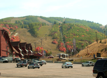
View uphill on CMG near the Midmountain Trail.
Original CMG description September 9, 2011 by Bruce, with the latest
update July 22, 2022.
A note about navigation: Park City's trail system is
extremely complex, with trail forks and crossovers coming at you
constantly. It's a struggle to keep them adequately marked -- I never
encounter so many lost riders asking directions as I do when riding Park City Mountain Resort (PCMR). I highly recommend riding with a
navigation app such as Trailforks. Also, Park City publishes a big
beautiful trail map that's updated yearly. Makes a nice souvenir.
Trail intersection where Jenni's, Flat Cable, and
Loose Moose come together in a complex join-and-split intersection. One
trail post. You'll have to stop to read the small print and see which way
the arrows are pointing.
The riding for these trails begins at 6900 feet at the main
PCMR parking lot. The top of CMG lies at 8600. The season for Loose Moose,
lower CMG, and First Time begins in early June, while upper CMG must wait
until July. Loose Moose is an intermediate trail, while CMG and First Time
offer easier riding.
Handlebar view as we descend lower CMG. The trail is
a wide and plush engineered bench-cut here.
Getting to the top of the trails
There are many ways to arrive at the top of these trails. If
you're starting at the resort base, I recommend Jenni's Trail. It begins
on Silver Spur, just uphill from PCMR parking lot. Find the path through
the concrete barriers, then aim for the singletrack heading to the right
as it climbs the hump in front of you. That trail is the Silver Spur.
Climb 0.2 miles, keeping to the left where the (unmarked in 2022) one-way
return from First Time joins from downhill on your right. Now Silver Spur
will fork to the right. Keep left and begin climbing on Jenni's.
Park City Mountain Resort parking. Go through a slot
in the cement barricades hear the condos to find the trail uphill.
Jenni's will cross First Time Return at 0.7 miles from PCMR
parking (also an unmarked intersection in 2022). Keep straight -- Jenni's
is on the right uphill.
Jenni's will reach the CMG crossover at mile 1.4 (1.6 from parking).
CMG below this is one-way. For a quick loop, veer left and descend CMG. To
continue climbing Jenni's, keep straight and right. If you plan to climb
CMG, make a hard right uphill. (Most people descend this section of CMG.
They may be riding fast and not expecting oncoming riders.)
Low on Jenni's trail, we're surrounded by a forest of
maple and oak.
At mile 2.9 from parking, Jenni's will reach a complex
intersection in a small grove of trees. Straight ahead takes you to Flat
Cable. Left is Loose Moose downhill. Turn hard right uphill to continue
Jenni's, keeping to the left when Loose Moose joins.
Loose Moose forks away from Jenni's to your right at mile 3.5 from
parking. (The upper portion of Loose Moose is 50 feet up Jenni's on your
left. It goes over to the top of Sweeney's Switchbacks and the bottom of
John's Trail.) Jenni's continues up to Drift Road, where a connector can
take you up to the Midmountain Trail. Right on Midmountain will take you
north to the upper section of CMG.
Crossing a ski slope on Jenni's trail, which winds in
and out of aspen groves as it climbs.
CMG (Crescent Mine Grade) trail
CMG is 4.3 miles long with 1700 feet of elevation loss from
top to bottom. The upper end is on the Thaynes dirt road at 8600 feet.
When planning a ride, it can be useful to divide CMG into three
sections: Thaynes to Midmountain (1.1 miles, two-way, with 450 feet
of elevation loss); Midmountain to the Jenni's Trail crossover (1.9 miles,
two-way, with 700 feet elevation loss); and Jenni's intersection to PCMR
base (1.4 miles, one-way downhill, with 500 feet elevation loss).
The CMG trail as it heads uphill from Midmountain.
Although the middle of CMG (from Midmountain to Jenni's
crossover) is officially two-way, almost everybody rides it top-to-bottom,
so it's best to consider CMG below Midmountain as a continuous downhill.
Rolling and twisting engineered trail on lower CMG.
Upper CMG (above Midmountain) is done equally in both
directions. It's often combined with Apex. This creates a reasonable route
for climbing to, or descending from, Charlie's 9K trail on the upper
mountain.
Following an old overgrown mine roadcut on CMG,
surrounded by a mixed forest of fir and aspen.
Upper CMG (Thaynes Road to Midmountain)
Let's start at the top. CMG begins on Thaynes Road, around 1/2 mile
downhill from the lower end of Apex. If you're descending Apex from
Charlie's 9K, turn hard left downhill at the bottom of Apex. Then after
descending Thaynes, make a hard right turn onto the top of CMG.
Upper CMG is just to the left of this trail marker.
We're looking up Thaynes Road. If we were going uphill, we'd pedal up the
doubletrack to reach Apex.
There's 450 feet of elevation change on upper CMG over one
mile of riding. If you're descending CMG, keep left when you pass a
connector called Short Fuse. Fork right when you reach the Midmountain
Trail. CMG and Midmountain are merged for 1/10th mile here as the combined
trails descend.
Rolling through aspen and fir on CMG.
When you hit a gravel road (Claimjumper Road), drop left
downhill on the road about 20 feet to find the continuation of CMG on your
right. This is not an intuitive trail fork, and you'll miss it if you
aren't reading the trail markers carefully.
A long look down the ski slopes from CMG.
Middle CMG (Midmountain to Jenni's crossover)
We now begin the middle section of CMG: from Midmountain to the Jenni's
crossover. As mentioned above, this section is two-way trail, but almost
everybody will be doing it downhill. It will be 1.9 miles with 700 feet of
elevation loss.
Smooth descending as we follow the old mine grade.
This portion of CMG follows an old mine road grade. The
slope will be gradual but steady. The trail is mostly smooth and wide.
At 1.1 miles from Midmountain, keep to the right on CMG as the Eagle
trail forks left. Eagle decends to Spiro for an alternate descending
route.
Rolling around a rocky outcrop.
When you reach a trail crossover (trail sign missing in July
2022) with Jenni's trail, keep straight (left and downhill). This is the
final lower CMG section, which is one-way downhill-only.
Handlebar view as we coast downhill.
Lower CMG (Jenni's crossover to PCMR base)
The bottom of CMG is one-way downhill-only. It's 1.4 miles in length
with 500 feet of elevation loss. This stretch of the trail has been
rebuilt so it's highly engineered and fast to ride.
Approaching a turn on lower CMG. The high sidewall
allows us to rock the turn with speed.
After descending 0.4 miles from the Jenni's crossover,
you'll see a trail uphill on your right. This is the bottom of Loose
Moose, so don't enter it.
Rolling the berm on the descent.
Turns are highly banked with a generous turning radius, so
it's easy to take them with speed. This portion of the trail is rated
intermediate, but experienced beginners should have no problem. But keep
in mind that groups of riders will be coming down this trail at blazing
speeds. I suggest that slow riders pick weekdays to avoid the crowd.
Handlebar view as we approach another fast turn on
CMG.
At mile 0.9 the CMG trail will break out onto a ski slope.
In about 50 feet, the CMG trail will turn hard to the right. The trail
that continues straight is the First Time Return trail.
From here, CMG will wind back and forth across the ski slope meadow as
it returns to the lift area.
The descent on lower CMG is a lot of fun!
Loose Moose
Loose Moose consists of a short upper segment linking upper
Sweeney's Switchbacks and lower John's Trail to Jenni's Trail, and a 1.1
mile downhill-only section that descends through multiple turns to end on
lower CMG.
There's 450 feet of elevation loss while descending Loose Moose between
upper Jenni's and lower CMG.
Bumping over roots during the initial drop down Loose
Moose.
The upper section of Loose Moose is only 0.2 miles long. It
traverses the hillside between Jenni's and a trail fork for Sweeney's and
John's trail. (If you're pedaling on upper Loose Moose from Jenni's, a
left downhill takes you down Sweeney's, while right uphill connects to the
the bottom of John's trail.)
If you're arriving from John's or Sweeney's on upper Loose Moose, turn
downhill right at the trail intersection with Jenni's, then fork left
about 50 feet later to descend lower Loose Moose.
Upper Loose Moose, looking southeast as we approach
the trail fork for Sweeney and John's.
Most riders will be arriving at Loose Moose, not from John's or Sweeney's,
but while climbing or descending upper Jenni's trail. From the Drift Road area
where multiple trails come together behind the ski lift, it's 1.4 miles downhill
on Jenni's to reach the top of the Loose Moose descent.
When climbing from the Park City base, it's 3.5 miles of climbing to reach
the top of the DH portion of Loose Moose.
Arriving on Jenni's at the top of the downhill part
of Loose Moose.
The terrain is a combination of maple and oak scrub forest,
thick aspen groves, and tall stands of fir.
Heading into a stand of fir on the descent.
From the upper Jenni's trail intersection down to CMG, Loose
Moose begins as a narrow and sometimes rough trail hugging the slope. Then
after it crosses Jenni's again, it becomes an engineered flow trail with
highly banked turns and a wider and smoother riding surface. The rough
upper half makes this an upper-intermediate ride.
The upper set of switchbacks tend to be narrow and
tight.
If you want to skip the tougher upper DH section, you can
simply turn to the left at the multi-trail intersection on Jenni's at mile
2.9 of your climb. This option is suitable for early-intermediates or
experienced strong beginners.
Approaching a turn. The upper half of the descent is
narrower, rockier and steeper.
Memory Lane! This was what Loose
Moose looked like
in 2011. Narrow singletrack with encroaching bushes.
The trail has been widened and in some
cases rerouted to
create a riding surface that's more friendly to non-experts.
After the initial 1/4 mile of descent on narrow singletrack,
Loose Moose will fall onto an old doubletrack for about 1/10th mile. The
strip has been bulldozed recently. Follow the track downhill to the area
above the Jenni's trail crossover.
Note that it's possible to link into Loose Moose from Flat Cable at
this spot, but I don't think many riders are choosing Flat Cable as an
access point to Loose Moose. Flat Cable is usually used as an alternative
climbing or descending route for Sweeney's, so it doesn't share a
trailhead with Loose Moose/CMG.
On the wide doubletrack. This spot may confuse some
riders. Just keep straight and downhill.
Find your way through the multi-trail Jenni's intersection
and descend past the Payday lift. Now the trail becomes a series of turns
on steep hillside. The riding surface here is generous, with wider turns
and clear sight-lines.
Bruce rolls into a turn on the lower smoother set of
switchbacks.
At the bottom of Loose Moose, you'll hit CMG. You'll make a
hard 180 turn to the right. Don't go straight -- CMG is downhill-only at
this location, and keeping straight will take you uphill against traffic!
Descend 0.5 miles of CMG, then select either First Time Return or lower
CMG for the final run back to parking.
Almost to the CMG trail.
First Time Return
First Time Return is a newer trail that offers an
alternative to lower CMG for the final run back to the base of PCMR. It's
0.7 miles long with around 150 feet of elevation loss. The trail is new in
2022 with trail signs not yet in place in July 2022.
On the traversing part of First Time Return, the
trail passes through a maple and aspen forest on a low hill.
You must descend CMG to reach First Time. The top of First
Time Return is located on a ski run, 0.5 miles from where Loose Moose
joins CMG or 1 mile downhill from the Jenni's trail crossover where CMG
becomes one-way downhill.
After climbing a little hill, we traverse a bit
before we hit the big turns.
As CMG crosses a small bridge to reach a meadow ski slope,
keep straight and left when CMG turns right downhill. You're now on First
Time (the fork is not marked yet in 2022).
The First Time Return trail will climb gently up a low hill and
traverse until it crosses Jenni's trail after 0.3 miles. At the crossover,
be sure to keep straight and to the left uphill. The trail to the right is
the uphill-only Jenni's trail. (In 2022, so many people have been going
the wrong way that there's a cheater trail to reconnect.)
Hitting the first turn. The turns are wide and highly
banked. Blazing fast for experts but good for beginners also.
First Time will now begin descending through a series of
highly banked engineered turns. The riding surface is wide and smooth. The
ride is appropriate for experienced beginners. This is fun stuff.
There will be some launch-pad bumps, and there are a couple of table
jumps.
Approaching a launching hump, then a downhill turn.
Approaching a table jump on First Time.
Almost done as we approach a turn under
the ski lift.
First Time Return is a lot of fun. Although the trail was
brand-new for my ride, the surface was hard and fast.
First Time will cross Silver Spur (keep to the right at the crossover),
then it will drop through a miniature valley to zoom up to rejoin Silver
Spur for the final descent to parking. These forks are unmarked in July
2022, but you'll figure it out.
An old tressle near the base of First Time.
A loop up Jenni's and down Loose Moose, CMG, and First Time Return!
If the above video does not appear on your
browser/device, you can watch it on YouTube by clicking
here.
Bottom Line:
Very nice trails. When combined with Apex, CMG offers a continuous
downhill from the 9K trail. Loose Moose and First Time are very nice
downhill routes for looping on the lower resort area.
Looking down to the resort from lower CMG.
Getting there:
PCMR main parking. Southbound on Park City's main drag (Highway 224,
Park Avenue), turn to the right towards Park City Mountain Resort (PCMR)
on Empire Avenue. Turn right again at Silver King Drive. Turn left on
Lowell Avenue and find the entry to the large parking lot. The trail will
be at the southwest corner of the parking lot, toward the Payday lift and
the Alpine Slide. Pass between the barricades heading west and look for a
singletrack straight ahead that turns to the right as it climbs a small
hill. That's the Silver Spur trail, which shares a common beginning with
Jenni's trail, your route uphill.