 |
I Street Jumps
The I Street Bike Park is located at the top of the Avenues area of
Salt Lake City. The riding area is only around 150 yards wide, but it's
packed with multiple lines leading to tons of jumps. It can be reached
directly from the 18th Avenue trailhead, or via the City Creek section of
the Bonneville Shoreline Trail.
Overhead view of a tiny portion of the I Street park.
Photos and confused ride by Bruce on September 13, 2021.
|
| While the park was intended to support riders of all levels,
at this time there's very little that's appropriate for a beginner or even
for most intermediate riders. For non-experts, it's almost impossible
to descend any line without running straight into a jump you can't handle
-- or getting in somebody else's way. Bottom line, if you aren't able to jump
your bike, you will not enjoy riding here.
Side view of a gap jump with some serious throw.
|

|
 |
The 18th Avenue trailhead on Hilltop Road gives you direct
access to the park. There's room for around 10 vehicles here, and it fills
up early with hikers. As you pedal from the parking area, keep to the left
and curve around the water tank. The main entry (drop-in) to the park is
on the opposite side of the water tank from parking.
Trailhead, looking north. The park is to the left,
around the water tank. |
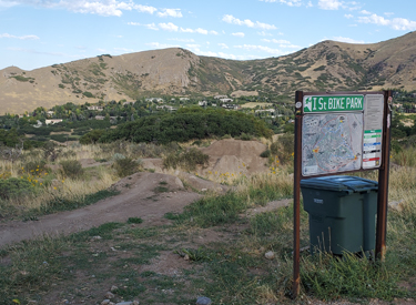
| In 2021, there's a picnic table and a trash dumpster at the
main drop-in. There's no water or bathroom.
Arriving at the main drop-in.
|
|
 |
From the main entry, trails fan out over 90 degrees. There
are map kiosks at the main drop-in, the north acess, and the western BST
(bottom) access. But there are no signs or trailposts that will help you
while you're riding. (I
did find one sign saying "up" but 30 feet later I was lost again
while trying to find my way back to the top.)
Aerial view of the trails radiating out from the main
drop-in. |
| You'll need to spend a bit of time here to figure things
out. The kiosk maps at the drop-ins over-simplify the system. The ideal is to follow a veteran on his favorite
lines. If you're all by yourself, well, good luck. These trails are total
chaos. Like a pile of Ramen noodles dumped in the dirt. Lines go
everywhere.
On the far south side, just leaving the main entry.
These southern lines have some of the meanest jumps. I'd suggest you go a bit to
the right and hit the trails down the middle of the park first!.
|

|
 |
The upside of all this complexity is that there's a hell of
a lot here, in a very small area. The whole park is less than 1/10th mile
top to bottom, side to side.
This is not a formal over-engineered park where every stunt was
carefully planned and precisely placed, then set in stone for all time.
The jumps were built by riders and are maintained by volunteer diggers.
And it's constantly evolving.
Three lines here. |
| And so, gentle reader, this trail review has no trail names
or specific recommendations. I'll tell you how to find the place. Then
you're on your own to find your favorite stuff.
Pick your drop.
|

|
 |
 |
A green route shown as "easy" on
the northern side is cut off
by a big trench as a gap jump is added. |
The green "double slalom" is
interrupted by this new huge
"not green" gap jump. |
 |
Here's the kiosk map in 2021. For high-res version that will
let you read the trail names, click
here to open the map in a separate window. But look between the lines
at the gray satellite photo. See all those white areas that are trails and
jump
lines? |
| In addition to the main drop-in, there's a northern entry.
From the trailhead, you can get there by continuing north 100 yards past
the water tank instead of curving around the edge of the tank. Now look for a
trail turning left that drops through a small dip to enter the riding
area. Look for the map kiosk.
You can also reach this trail by taking the right-most trail from the
main drop-in. This trail will traverse across a shallow ridge at the top
of the park.
Middle of the park. Riding lines crossing and
twisting.
|

|
 |
The third entry to the park is at the bottom. Here the City
Creek uphill-only section of the BST sends a spur through the log fence.
Rather than enter here, I'd suggest that the BST is a good uphill route to
take you back up to the top of the park after a run downhill. See the my
map below for the trail alignments.
Looking up at the entrance to the park from the BST. |
| There's a small designated "beginner loop" at the
bottom of the park, just inside the gate from the BST. Go ahead and check
it out.
There's a bit of wood stuff -- some falling apart,
some still solid.
|

|
 |

|
| The dual slalom trail, looking uphill... |
and downhill. |
 |
Bottom Line:
Fun stuff for truly expert riders -- youngsters who have yet to separate
both their AC joints and who still own many non-broken ribs. And who have many fewer years of wear and tear than
some of us. Expect to spend some
time learning the lines.
The only on-trail sign I saw. But 30 feet later, I
was lost again. |
 |
Getting there:
In northern Salt Lake City, turn off South Temple onto I Street northbound
(uphill). Continue uphill until the road turns to the left and becomes
North Hills Drive westbound. Follow it around the turn to go east again.
It will then become 18th Avenue. Just after the church, watch for Hilltop
Road on your left. Go up to the parking area.
No bathroom or water at trailhead.
Map note: the tracks on this map are simply my own meanders as I
explored the park and do not correspond exactly to "official"
trails.
Trail Resources!
GPS track file (right-click and select "Save Target as..."):
GPX multi track area file
Topo map region for printing: View
Lodging, camping, shops: Links to
NE SLC resources
|

|


