 |
Nung'wu Poa
(Paiute Trail)
The Nung'wa Poa is a short trail on the southern edge of Springdale.
The trail is new in October 2021. And while it still needs some work to
ride smoothly, it's open. I'd give the ride an upper-intermediate rating
because of a steep loose climb required to reach it. Once the surface has
been ridden in -- and a few problem turns are worked over -- Nung'wa Poa
itself will rate intermediate in technical difficulty.
Looking east toward the entry to Zion from Nung'wa Poa.
Initial ride and review by Bruce on
October 20, 2021. |
| The Paiute Trail itself is one mile long, sitting at around
4000 feet elevation just outside Zion
National Park. The ride up to the trail and back adds a mile to the round
trip.
Nung'wa Poa -- which translates to "Paiute Trail" -- is on Paiute
Tribe land. The area will receive snow in the winter, so the
expected riding season would be March through December.
Looking south from one of the many meanders while
riding clockwise.
|

|
 |
To reach the trail, park at the first lot along Highway 9 in western
Springdale. Parking in Springdale requires credit card payment, available
at kiosks. Then pedal the paved path to George Barker River Park, about a
mile to the east. In the park, take the sidewalk to the
footbridge over the Virgin River.
Note that the few parking spaces within River Park itself are restricted to
those currently using the park -- picnics, etc. Do not park here merely to pedal away.
The bridge from River Park to the Nature Trail, which
will be your route to Nung'wa Poa. |
|
Immediately across the bridge is the Mary Bonner Nature Trail. The nature trail is a 1/2 mile loop, with a 0.2-mile dead-end
extension east from the loop along the Virgin River. I saw no indication
that the loop is restricted to foot traffic, and there were bike tracks.
But evaluate the number of strolling tourists on the trail before you
decide to ride around the loop.
Looking east at the Virgin River from the nature trail.
|

|
 |
The nature trail forms a small loop south of the
Virgin River (see map), with one corner at the foot bridge. As you cross
the bridge, keep straight and head
away from the river toward the sage-covered
hill.
After about 50 yards, you'll come to a trail fork. Keep to the right to exit the nature
loop, aiming for the metal gate on the edge of the hill.
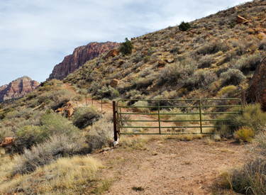
Go around the gate at mile 0.1 from the bridge and begin climbing.
Here's your target. Go around the gate to the right
and begin climbing.
|
| The climb up the doubletrack is stiff, gaining 150 vertical feet in 1/4 mile. I found the
traction to be OK -- three days after a heavy rainstorm -- but at times there will be loose rock and churn.
Many riders will need to walk their bikes here.
Climbing the doubletrack up from the valley. Steeper
than it looks.
|

|
 |
At around mile 0.4 from River Park, look for singletrack
forking away to your left. This is the northern (downhill) side of the eastern loop
of Nung'wa Poa. At this time, it's the easiest way to find the trail.
Northbound shortly after entering the eastern loop
clockwise. |
| The eastern loop has great views of the Zion area as it
meanders back and forth. When done clockwise, it will gradually gain
elevation. At mile 0.8 of the loop, you'll arrive back at the doubletrack just uphill
from the starting spot.
Looking east over Springdale into the mouth of Zion
Canyon.
|

|
 |
Once you're back at the doubletrack, turn hard left uphill. Immediately look for a
singletrack path on your right forking away from the main doubletrack.
(The doubletrack continues uphill to a ridgeline, then continues as a
narrow trail through the sage brush to another ridgeline viewpoint. The trail then peters out.)
A section of nicely worked-over trail on the eastern
loop. Most turns will not be this plush, but will be tight and raw -- for
now. |
| After turning to the right from the broader trail, keep left
at the trail fork just 20 feet from the doubletrack. As of October 2021,
brush has been cleared but little work has been done on the actual trail
surface. So it barely resembles a trail in some spots. Follow the cleared
path around the small hill for 1/4 mile. It will loop back and rejoin the
outgoing trail near the
doubletrack. This western loop trail will undoubtedly be more obvious by
the time you ride it. Looking west on the cleared path for the smaller west
loop. Doesn't look much like a trail at the time of my check-out ride.
|

|
 |
Getting there:
Take Highway 9 to Springdale. As soon as you enter town, look for a
parking strip on the right side of the road. (All parking in Springdale
requires a fee, which can be paid at a kiosk with credit card.) Start your
ride on the paved bike path eastbound along the road. Go around a mile
east before turning right into George Barker River Park. Get onto the
sidewalk and head for the foot bridge at the southern side of the park
along the river.
The parking spots in River Park are reserved for those
actually using the park. If your family will have a picnic while you ride,
fine. Otherwise, park elsewhere (paying your parking fee) and pedal the
paved path along Highway 9 to the park.
Resources:
Download area tracks
Lodging, camping, shops:
Links to St.
George area resources
|
|


