 |
Captain Ahab
Captain Ahab is a one-way trail in the Amasa
Back riding area. It must be reached via the Amasa
Back or Hymasa trails. This singletrack requires good technical skills,
confidence, and strength. It's a great ride, but it's not a cruiser. It
was designed as an expert-level singletrack.
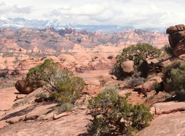
Near the top of Captain Ahab, looking
southeast toward the La Sal Mountains. Ride description by Bruce
on April 11, 2013.
|
General information:
The singletrack is 4.3 miles in length. While it's one-way, it's not a
"downhill" trail. From the ridgeline 2.7 miles up Amasa Back it
will ascend 300 feet in altitude, but up-and-down riding tallies almost
1000 vertical feet of climbing over the course of the trail.There are great views
all along the way, and fabulous-forever views at the top. Add those views
to the riding, and every rider I've talked to absolutely loves Captain
Ahab.
Just getting started on Amasa Back. This is your
view as your bike hits the heavy sand above the creek. Go for the rock
pile, but you won't make it. |

|
 |
A ride directly up Amasa to Captain Ahab and looping back will
be 8 miles and 1800 vertical feet of climbing. Alternate: climb via the
new Hymasa singletrack.
I'll also describe an Epic Tour of Amasa for 17 miles and 3000 vertical
feet. This is a monster ride, hitting all of Amasa,
Pothole Arch, Rockstacker, and
Captain Ahab.
We're a mile up Amasa. This is the
return path from Captain Ahab. |
| There's also the option of cutting Captain Ahab in half by
using the midway connector. Take the connector at Amasa mile 2.3, ride 1/2
mile to Ahab and turn left. This will visit the lower half of Captain
Ahab, which is almost purely downhill. The ride will be 5.9 miles, with 700
vertical feet of climbing. If you have a heavy DH rig, this is your path.
View back down Kane Creek Canyon as we
climb up Amasa after a spring shower. The domes are Navajo sandstone. The
ledges are Kayenta.
|

|
 |
You can also use the connector to bail out after doing upper
Ahab. While you've already done most of the heavy lifting, the connector
plus lower Amasa is technically much easier and will go faster. Use this
route if you've broken down (bike or body) or run out of time.
View on the connector trail. It's 1/2 mile on this trail between the
midpoint of Ahab and Amasa. |
The Ride:
Navigation for the short loop is straight-forward. Ride the Amasa Back
trail 2.7 miles to the ridgeline, fork left on Captain Ahab, and follow it
back to Amasa.
The ride uphill is on ledgy Kayenta
sandstone, with occasional spires and bumps of Navajo.

|

|
 |
From the Amasa Back parking, pedal uphill on gravel road 0.6 miles. At the
sign, drop right over a series of ugly rock stairs. The smoothest line is: far
right, then cross over in the middle of the steps to far left.
At the
bottom is a big drop. There's a sneaker route on the far right.
Lay of the land. We're on Amasa
looking back at the ridgeline where Ahab starts, from about 1/2 mile
further uphill. Ahab will go past the spire on the left and climb along
the row of cliffs (toward the right in the photo). |
| Most bikes now keep left, while 4x4s go down to the right.
The paths rejoin just before the creek. Splash through and bog down in the
sand. There's a mean ledge up ahead, but you'll never keep enough momentum
to clean it.
The entry into Captain Ahab at the
ridgeline of mile 2.7 on Amasa Back.
|

|
 |
Amasa is series of ugly tough ledges spaced between
stretches of ugly tough climbing. It's Not My Favorite Moab Trail. But
then I'm a old crybaby with lots of slow-twitch fibers, and you're a
biking god. Climb that hill.
The trail is marked with blue stripes
on slickrock areas. This is early in the ride on a smooth section. |
| At mile 1.0, turn to the right as the bottom of Ahab joins
on your left. Do Not Enter. Captain Ahab is one-way, and for good reason.
At mile 2.3, keep right as the connector to Ahab's midpoint veers off
on your left. Or go left if you're looking for the short-short version of
the ride.
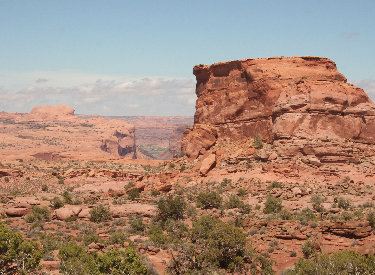
View toward the Colorado River as the
trail climbs along the cliffs. The mid-ground mesa is Jackson Not Hole.
|

|
 |
At mile 2.7, Amasa crests a ridge. Most riders stop here to
take in the view. To do the short loop, immediately fork left onto the
singletrack of Captain Ahab. (For the epic ride, continue on Amasa.) About
100 yards west on Ahab, Hymasa joins on your
left. Keep right.
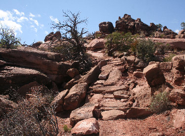
This trail has seen a lot of work to
create countless rock ramps. Approaching what looks like a 10-foot cliff,
we spot a rock ramp at the last second. |
| Shortly after entering Ahab, you'll realize you've got
climbing to do. The trail follows the anticline uphill to the
same elevation as the Amasa viewpoint. Over 1/2 mile, you'll gain 200 feet
of elevation, but you'll climb two or three feet for every foot you keep.
Typical trail view looking toward the
La Sals.
|

|
 |
There are constant turns and up-and-downs. Flat sections are rare and very short. The bike bucks up and down constantly.
But there isn't anything as technically difficult as the ledges on Amasa.
Plan to bring fresh legs and an aggressive attitude. If you want
cruising on similar sandstone, try Bull Run and Little
Canyon. This trail seems designed to
serve up fun challenges. Don't plan to mosey along with your butt on the
seat.
Glimpse of the Moab valley. |
|
Once you're finally heading downhill, you'll still be cranking uphill frequently. As you approach
the midpoint, you'll be maintaining some flow and speed.
Rock ramps are everywhere. The
trailbuilders seem to take the toughest line, then place rocks so you can
get there.
|
|
 |
The bottom half of Captain Ahab flows better. There are longer
sight-lines and the course of the trail feels more intuitive. But there will
still be some stiff little uphills, so you're not through working yet.
As the trail approaches Whale Rock, we're
able to maintain a bit more speed. |
| As you enter the gorge, you'll see why this is a one-way
trail. There are quick up-and-downs as you hug a band of tilted rock
midway down the cliff. It's advanced, but not extreme, technical.
At mile 7.0, you'll rejoin Amasa. Want another loop?
At the midpoint. That's Whale Rock.
Captain Ahab... Get it?
|

|
 |
The Epic Amasa Figure-Eight Ride:
The Epic Tour of Amasa is harder than it sounds. You'll already be tired when you hit
the climbing on Captain Ahab.
The ride is a figure-eight with a couple of loose threads. Take
Amasa to the viewpoint and back to the Pothole Arch trail.
(The little out-and-back is a "loose thread" on the
figure-eight.) Take Pothole
Arch out to its viewpoint and back to Rockstacker.
(Another loose thread.)
Skirting the cliffs above Kane Creek. |
| Take Rockstacker to the Jackson ST connector, but cross the
ridge to Amasa. (Don't go down Jackson!) Ride a mile to Captain Ahab. Finish with Captain Ahab
back to Amasa. It's 16.5 miles with 3000 vertical feet of climbing.
The trail rockets up and down as it
hugs this break in the cliffs. You do see the trail, don't you?
|

|
Riding notes, short loop:
0.0 Exit parking, uphill on road N38 31.710 W109 35.705
0.6 Drop R off road N38 31.435 W109 36.096
0.7 Take air off ledge, turn right on DT
Alt = ST straight shortcut
0.8 Cross creek N38 31.589 W109 36.080
1.0 Turn R (L = exit from Captain Ahab)
N38 31.521 W109 36.261
2.3 R at fork (L = mid-way Ahab connector)
N38 31.057 W109 36.804
|
2.7 L onto Captain Ahab)
N38 31.098 W109 37.114
4.9 Cross connector
N38 30.809 W109 36.594
7.0 R downhill on Amasa
N38 31.521 W109 36.261
7.2 Cross creek
7.5 L downhill on road
8.0 Back at parking
|
Riding notes, EPIC Tour figure-eight:
0.0 Exit parking, uphill on road N38 31.710 W109 35.705
0.6 Drop R off road on Amasa Back
N38 31.435 W109 36.096
0.7 Take air off ledge, turn right on DT
Alt = ST straight shortcut
0.8 Cross creek N38 31.589 W109 36.080
1.0 Turn R (L = exit from Captain Ahab)
N38 31.521 W109 36.261
2.3 R at fork (L = mid-way Ahab connector)
N38 31.057 W109 36.804
2.7 R on DT (L = Captain Ahab)
N38 31.098 W109 37.114
2.8 L (straight), R = to view
N38 31.161 W109 37.126
3.0 Cliffside along Jackson Not-Hole
3.7 Pass Portage connector, keep straight (R)
N38 31.721 W109 37.678
(L=cliff scramble down into
Jackson Hole)
3.8 Keep L at fork (R = Jackson ST)
N38 31.761 W109 37.756
4.3 Straight (or R = jeep route)
N38 31.788 W109 38.198
4.5 Keep L on Amasa (L = Pothole Arch trail)
N38 31.876 W109 38.369
|
5.0 View - End of Amasa - head back
N38 31.619 W109 38.554
5.5 L on Pothole Arch
N38 31.876 W109 38.369
6.6 Keep L (straight) to Pothole Arch
N38 32.533 W109 38.449
7.4 At Pothole Arch - head back
N38 33.106 W109 38.448
8.2 L on Rockstacker
N38 32.533 W109 38.449
9.9 L uphill on DT, cross ridge
(R = Jackson ST)
N38 31.747 W109 37.594
10.2 L on Amasa
N38 31.761 W109 37.756
11.3 R onto Captain Ahab
N38 31.096 W109 37.113
13.5 Cross midway connector
N38 30.812 W109 36.597
15.6 Join Amasa, downhill
N38 31.521 W109 36.261
15.8 Cross creek
16.0 L down Kane Creek Rd
16.6 Back at parking |
 |
Getting there: Head south on Moab's Main Street. When you
reach the McDonald's on your right, turn right onto Kane Creek Blvd. After
0.6 miles, go straight where the road seems to turn right (500 West).
Drive along the Colorado River about 5 miles until the road turns to
gravel, and head uphill about 2/3 mile. Watch for the "Amasa Back Parking"
area at GPS N 38° 31.329' W 109° 35.501'. Park here. Pedal further up the gravel road 1/2 mile, and
turn right onto the trail at the sign. |

|


