 |
Bennie Creek to Beaver Dam Loop
This longish loop is reserved for strong, conditioned riders with
good downhill skills and a sense of adventure. It's pretty, it's fun, but
it's tough.
Riding from an altitude of
5400 feet at Birdseye in Spanish Fork Canyon, you'll climb to 8400 over
the top of Payson Canyon, then drop down Beaver Dam Canyon and roll out
along Nebo Creek Total climbing on this 22.7-mile loop will be around 3500
vertical feet. Definitely strenuous aerobic. Advanced technical, but can
be managed by intermediate-technical riders who are strong and
adventurous.
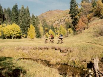
Chris rolls down the Beaver Dam Trail.
October 9, 2002. Photo by Bruce.
|
| The ride starts on doubletrack in the village of Birdseye.
Rapidly, you leave farmland behind and enter forest of maples, oak, and
fir. After 4 miles, it rises on singletrack to the ridge separating the
canyons. The last 1/4 mile gets really steep, and may require push-a-bike
unless conditions (and your legs) are perfect. At the ridge, the trail
forks left for a mile on the Loafer Mountain Trail, then forks left again
on the Blackhawk Trail. Now you're riding through broken aspen forest,
with occasional maple and fir. Meadows give you great views of the
surrounding mountains.
After a bit of doubletrack, the
singletrack climbs along Bennie Creek towards the ridge. Front to back are
Chris, Mike, and Dominic.
|
|
 |
The trail forks off the Blackhawk Loop to follow the
Blackhawk Trail (Blackhawk and Blackhawk Loop are different trails) up and
over the road at 8400 feet. Then it drops down the Beaver Dam Trail, which
(at least, the way we rode it*) has some stiff little climbs on the lower
half -- just when you're ready to quit and go home. The descent is fairly
steep and somewhat, but not horrendously, technical. It drops over 2000
vertical feet in about 3 miles -- and that includes a bit of
"climbing back up!" Mike
grinds uphill through the golden aspens on the Blackhawk section of the
loop. |
| *We passed a trail fork that went hard-right down to the
creek, just when the trail began climbing up the mountainside, about 1-1/2
miles down Beaver Dam. It appeared that the main trail went straight
ahead, rather than dropping back to the creek. We went straight, which led
to a significant amount of additional climbing on narrow, fairly technical
singletrack, with some steep-but-short tech descents to make up for the
climbing. This trail rejoined a trail in the creek bottom a mile later. It
will take another visit to determine whether there's a trail alongside the
creek for the whole downhill. (If so, it would make the descent a lot
easier and faster.)
Bruce crosses a large meadow on the
Blackhawk Trail. |

|
 |
After the descent down Beaver Dam, the route forks left on
the Nebo Creek Road, a high-speed dirt and gravel road that will take you
back to the highway. This road allows speeds in excess of 24 mph. Judge
for yourself what speed your tires can hold as you head into the gravel on
turns.
Chris rides towards Mount Nebo, seen
between the trunks of the aspens. |
|
This is an epic, all-day ride. Don't even dream of taking a newbie
around this loop. Depending on trail surface conditions and your climbing
strength, actual in-the-saddle time is likely to be between 6 and 9 hours.
Dominic plunges down the Beaver Dam
Trail. Some sections of this trail are plush, others are a bit primitive
and rather technical. As more bike tires hit this trail, it will get
better! |

|
 |
When this trail is wet, it can get significantly more
difficult. The Nebo area is popular with horse riders, especially around
elk and deer season. After a big rain, the horses do incredible damage to
the trail surface. We rode in the middle of elk season, a few days after a
big snowstorm. Many damp areas were pitted up to 12 inches deep, requiring
big-time effort and control to fight through. Some sun-exposed areas were
dry, and the 8-inch-deep hoofprints rattled your fillings loose and made
control difficult.
A "cruiser" section of the
Beaver Dam Trail, as Bruce hurtles down towards Nebo Creek.
|
Riding notes:
0.0 Start west from parking on S side of church
N 39° 55.458' W 111° 32.905'
Alt = 5400
0.8 DT goes left of home, through metal gate
2.5 Cattle grate at border of National Forest
3.5 Deer Hollow Trail comes in on R
N 39° 56.408' W 111° 35.940'
4.0 DT ends in ST, continue straight ahead
N 39° 56.366' W 111° 36.462'
Alt = 6600
6.2 Steep up to coral, fork L (Loafer)
N 39° 57.122' W 111° 38.454'
Alt = 7900
7.1 Fork L up through gate (Blackhawk)
N 39° 56.497' W 111° 38.499'
8.5 Fork L downhill (R = out to road + Rock Springs Tr)
N 39° 55.819' W 111°
37.822' Alt = 8100
9.3 Keep straight (Ranger Station trail in from R)
N 39° 55.410' W 111°
37.574' |
9.6 Fork R at sign (L = Blackhawk
Loop)
N 39° 55.147' W 111° 37.617'
11.0 Cross paved campground road
N 39° 54.542' W 111°
38.373'
Trail through fence going
west
11.6 4-way fork - straight 50 ft, then hard L downhill.
N 39° 54.155' W 111° 38.337'
approx 13 Straight (R = downhill, possible alternate)
Climb along hillside
14.7 Trail joins along creek, go L downhill
N 39° 51.685' W 111° 37.645'
15.0 Drop onto Nebo Cr Rd, turn L
N 39° 51.418' W 111°
37.600' Alt = 6300
20.4 Gate end Nebo Cr Rd, L on paved road
N 39° 53.528' W 111°
32.957'
22.7 Back at parking |
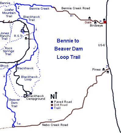 |
Getting there: From I-15 in Utah County, take
the Spanish Fork - US-6 exit and drive up Spanish Fork Canyon. Just past
the Billie's Mountain landslide (about 5 miles up the canyon), turn right
on US-89. Five miles later, spot a small white church on your right. This
is Birdseye. Turn right at the far end of the church, and park along the
south side of the church. The ride starts by continuing west on the road
into Birdseye.

|
|


