|
Forbidden Trail
Includes More Effort
The Forbidden Trail is part of a popular route from Alpine to Draper.
It can be part of a long loop ride in the mountains north of Alpine when
combined with Three Falls Fort Canyon plus
either Vista Ridge and Stoney Way or Bodily
Harm. It's intermediate in tech requirement, with around 700 vertical
feet of climbing from Alpine to Fort Canyon. See the area overview page
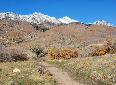
for links to other area trail pages. Looking
north toward Lone Peak on the Fort Canyon side of the trail, descending
toward Three Falls. Original
photos and trail notes August 2018 by Bruce.
Latest trail update April 18, 2022. |
| On Alpine's Grove Drive, head north to the second T intersection (where a right turn would take you
across the bridge into Lambert Park). Instead, turn left on Alpine Cove Drive. At
the 4-way intersection, turn left. As Alpine Cove Drive turns downhill,
turn uphill on Aspen Drive. It will turn to the Three Falls Lane road. As
the larger road veers left, keep straight onto a smaller dirt road and
quickly find the trail on your left. (Alternatively, continue uphill to
the Schoolhouse Springs trailhead and take the connecting trail downhill
to Forbidden. See the map.)
View of the Forbidden trail entry in spring 2022. |

|
 |
At the first T intersection when northbound on Alpine's
Grove Drive, turn left. After 1/10th mile, turn left again. Go 1/10th mile
and turn right on Savannah Circle, then right into The Ridge trailhead.
Take Stoney Way northeast 1/2 mile. Keep right as you reach Bodily Harm
and traverse another 0.2 miles. Hike-a-bike up to the road and cross to
find Forbidden on the other side.
The Ridge (Big Hollow) trailhead. Stoney Way goes
both directions from here. |
| From the Fort Canyon Ranch Trailhead in Alpine's Fort
Canyon, you can reach Forbidden by taking the Three Falls Fort Canyon
trail. Keep left as Vista Ridge, Last
Chance, and Bodily Harm fork away on your
right. Descend into upper Fort Canyon, cross the paved road, and climb
uphill about 1/10th mile. At mile 2.4 from the Fort Canyon Ranch
trailhead, fork to the right on Forbidden.
Looking northeast in the paved parking lot in Fort
Canyon. The Three Falls Fort Canyon trail is just to the left of the
bathroom. |

|
 |
On Alpine's main street, continue north until the road turns
right at Fort Canyon, then watch for a small paved Heritage Hills (North
Point) trailhead on your left in about 1/4 mile. Climb up through Heritage
Hills until you reach Stoney Way and turn right. Traverse the hillside
northbound for 1.5 miles to reach Forbidden across the Fort Canyon Lane
road.
View up Dry Canyon with the North Point trail
straight ahead.
|
|

|
The Forbidden trail, finished in late summer 2018, lies to the
northeast of the Bodily Harm (historic
Neph's Lake) route. It's 2.6 miles long,
running from Alpine Cove to the Three Falls trail in Fort Canyon. The
trail begins on the Schoolhouse Springs (Hammagog) road just after it
leaves the Three Falls subdivision road. Heading uphill toward Lone
Peak on the lower segment of the trail, near Schoolhouse Springs in Dry
Creek Canyon. |
|
A connector from the small Lone Peak (Schoolhouse Springs)
trailhead joins Forbidden one switchback uphill from the creek. There is
currently very scant parking at the bottom of Forbidden, so you'll likely need to use the
Schoolhouse Springs trailhead or find roadside parking away from the
construction area if you're driving into the area. Looking
east toward Box Elder Peak from the Forbidden Trail in Fort Canyon.
|

|

|
Across from lower Forbidden on the Three Falls Lane road
is the combined Stoney Way and Bodily
Harm trails heading southwest.
The upper end of Forbidden is on the Three Falls
trail to Draper, just east of the bridge over the big ravine and above
the Three Falls Lane road. A left turn downhill takes you to Three
Falls Fort Canyon, while a right turn takes you toward Draper. View
across upper Fort Canyon at the highest point of the Forbidden trail at
around 5900 feet elevation, looking south. |
|
At mile 0.9 of Forbidden, the More Effort trail (see
below) joins on
the left as Forbidden turns hard to the right.
The trail hits crosses a road at mile 1.7
from the bottom. The continuing trail is at the break in the fence just
across the road. This is the highest elevation of the Forbidden
trail. The trail now begins dropping into Fort Canyon. It will join
the Three Falls trail in another 0.7 miles. Here a left turn takes you
down and across the road, and a right turn takes you across the bridge on
the Three Falls trail toward Draper. Bruce rolls a
turn in the maple forest during an April ride.
|
 |

|
In the downhill direction, around mile 1.6 from the Three Falls trail
fork the Forbidden trail settles into a series of long traverses between
switchback turns as it slowly sheds elevation.
At mile 1.7, keep left on a turn as More Effort joins the
middle of that turn from your right.
Typical stretch of trail above Alpine Cove.
Exposed trail winding back and forth across the mountain between tight
turns.
|
|
As you get close to the bottom, at mile 2.5, a trail joins
from the left. This is the connector to the Lone Peak trailhead uphill. If
you continue straight, it will take you down another couple of turns,
through the creek, and you'll join the trailhead road at mile 2.6. Rolling
west above the Fort Canyon subdivision road in April 2022. A sliver of
Utah Lake can be seen below Lake Mountain.
|

|

|
I really like the Forbidden trail as a climber. It's less
steep than Bodily Harm. From Alpine Cove to Three
Falls, you'll do much of the elevation gain on the traverses. They work a
lot better uphill than downhill, I think. The trail has 600 feet of elevation
gain. The
surface is smooth and turns have a generous radius. It's a fairly easy
trail to pedal.
Looking toward Lambert Park on the Dry Creek side of
the hill. At the bottom is the
Lake Hardy/Hammagog equestrian trailhead. At lower mid-photo are the homes
of Alpine Cove. Lambert Park sits like a fat "U" around the
homes of Box Elder, right in the middle of the picture.
|
|
A loop ride from Alpine Cove using Forbidden, Three Falls
Fort Canyon and Bodily
Harm will be 5.5 miles with 1000 vertical feet of climbing.
Looking east at the entry to Forbidden from the Three
Falls trail just north of the Fort Canyon road.
|

|

|
A loop up Forbidden, Three Falls Fort Canyon, Bodily Harm
to EZ Breezy, up Last Chance, then Vista Ridge to Stoney Way is 9 miles
with 1500 feet of climbing.
Rolling a switchback on lower Forbidden while
descending the trail toward Schoolhouse Spring in Dry Creek.
|
 |
More Effort is a connecting trail between Bodily Harm and Forbidden, 0.6 miles in length. Starting from
Bodily Harm, it will cross the
Three Falls Lane road and climb 150 vertical feet to join the Forbidden
trail.
The trail can be used as the bottom of a long loop from above, joining
Bodily Harm and Forbidden. Or for beginners, it can be the top of a short
loop starting from Alpine. The new origin of More
Effort. Seen as if climbing Bodily Harm. Bodily Harm is a 180 degree turn
to the left; More Effort is straight ahead. |
| When climbing Bodily Harm, the fork for More Effort comes at
mile 0.5, on the right. (180 degrees right continues uphill on Bodily
Harm.) After leaving Bodily Harm, the trail will reach the Three Falls
Lane road in 1/10th mile. Go uphill slightly to turn into the continuing
trail.
Rolling through the oak brush after crossing the
Three Falls Lane road.
|

|
 |
More Effort joins Forbidden in the middle of a hairpin turn, 0.9 miles
from the bottom.
Ready to join Forbidden, uphill or down, from More
Effort. We're looking northeast. The flags are marking the route for an
upcoming bike race. |
 |
Getting there, Fort Canyon Ranch Trailhead: As you drive into Alpine
on Main Street, keep straight at all intersections until you reach 800
North. Then, just as Main Street turns to the right and becomes Heritage
Hills Drive, fork left on Fort Canyon Road to continue north. 0.9 miles
later, turn right just before the Three Falls gate. Quickly turn left into
the parking lot for the Three Falls Farm trailhead. Pedal up Three Falls,
crossing upper Fort Canyon, to reach the upper end of Forbidden.
Heritage Hills (North Point): Shortly after you veer to
the northeast from Main onto Heritage Hills Drive as above, spot the small
parking lot on your left and turn in. Pedal up through the subdivision and
find Vista Ridge/Heritage Hills heading uphill. If you're heading for the
top of Forbidden, keep left. For the bottom of Forbidden, go right for 1.5
miles.
The Ridge TH (Stoney Way and Big Hollow): At the T intersection of Grove Drive,
turn left and follow the road to another T intersection. Turn left, then
right on Savannah Circle. As it approaches the mountain the trailhead is
on your right. Take Stoney Way 0.7 miles northeast to find Forbidden on
the opposite side of the Fort Canyon Lane road.
Facilities: bathroom at Fort Canyon trailhead, bathrooms at Lambert
Park trailheads. (No services at Schoolhouse Springs, The Ridge (Big
Hollow), or Heritage Hills
trailheads.)
See below for the Schoolhouse Springs trailhead area routing as of August 2021.
|
| Getting there, Alpine Cove - Schoolhouse Springs: Instead of turning left
on Fort Canyon Road, stay on Heritage Hills Drive. Turn left uphill on
Grove Drive. At the T intersection (where a right turn would take you
across the bridge into Lambert Park), turn left on Alpine Cove Drive. At
the 4-way intersection, turn left. As Alpine Cove Drive turns downhill,
turn uphill on Aspen Drive. It will turn to the Three Falls Lane road. As
the larger road veers left, keep straight onto a smaller dirt road.
There's a spot to your left just after you leave the main road. That's the
beginning of the trail.
To start from the formal trailhead, go 1/4
mile uphill and park at the Lone Peak trailhead. Go all the way up to the "Lehi"
gate and turn left to get on the singletrack that dips through the creek.
Keep left and descend on the trailhead connector. You'll find a connection
to Forbidden on the right. To reach Bodily Harm, you'll need to coast all
the way down to the raised Three Falls Lane road, then crawl up and over
it to find Bodily Harm on the opposite side.
|

|
Copyright 2022 UtahMountainBiking.com
division of Mad Scientist Software Inc
|


