 |
Holly's Trail
Holly's Trail goes from the base of The Canyons resort at Park City to
the Mid Mountain Trail. It's 4.1 miles long, rising from 6900 to 8200 feet
in elevation. Some up-and-down riding brings the total climbing from base
to Mid Mountain to 1500 vertical feet. It's suitable for experienced
beginners if they're strong and conditioned.
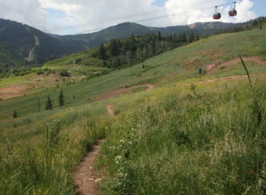
View on the downhill as Holly's contours along the
hillside. Original trail review 2010, updated by Bruce on July 1, 2016
with new photos, new track and additional connections.
|
| The trail serves as a climbing route to the Mid Mountain
trail, or as access to the Red Canyon Lodge and the Alpine Lake trails of
the upper The Canyons resort. You'll find it used as a hiking route uphill
and down. It's also a good descending route for mixed-ability groups or
for locals with dogs.
The lower trail makes a few passes on the ski slope
above the lifts to gain altitude. The trail beneath the gondola is
Ricochet, a downhill-only route.
|
|
 |
The trail is generally smooth and generous in width,
suitable for experienced beginners with good legs. There are no technical
features or steep pitches. But it's a taxing climb if you hammer uphill
without a break.
As we leave the ski runs, this sign welcomes us to
cool shady forest. Alpine Lake is a trail in the upper The Canyons' Bike
Park, reached from the top of Holly's via Mid Mountain. |
| Almost all of the ride clings to the north-facing slope of
the canyon, so it tends to stay cool longer on summer mornings.
There will be an occasional view up the canyon, or of the valley when
descending.
The trail breaks out onto low scrub, offering a view
to the west uphill.
|

|
 |
The trail is 90% deep shaded forest. It's a mix of aspen and
fir. There will be occasional areas of maple and oak where the hillside
turns to catch more sun.
This is fairly typical of much of Holly's:
mixed aspen and fir. |
| Navigation has two spots that may confuse you. One is simply
finding the trail through the mass of buildings at The Canyons' base. If
you found the parking lot, just head north through the upper commercial
area, pass the gondola, and drop downhill then left on doubletrack. Follow
this golf-cart track uphill until you see the singletrack forking left
uphill in about 0.2 mile.
Looking east downhill. The south wind has blown in
some smoke from distant forest fires.
|

|
 |
The second confusing spot is at the mid-way lodge. When climbing,
mile 2.5 will drop you onto a gravel road with an immediate fork in the
road. When you reach the fork in the road DON'T GO UPHILL. Turn hard to
the left and drop downhill on the doubletrack. Now veer right and climb
above the building. Keep straight here and continue until it looks like
singletrack again, going downhill towards the creek. THREE one-way trails
will join on your right.
Elderberry, willow, and choke cherry fill a space
between tall aspens. |
| When you reach the creek, keep straight as Ricochet (one-way
downhill) forks away on your left. Begin climbing again.
In the downhill direction, here's your navigation: from the
creek, keep straight and aim for the uphill side of the lodge. Drop
downward on doubletrack, keeping straight as it goes uphill again. When
you reach the DT fork, turn right downhill, then immediately veer left on
the singletrack.
We're above the confusing trail junctions and
climbing for real. In the little clearing on the right, you can see a
piece of Ricochet, which comes close to Holly's at several spots.
|

|
 |
The section after the creek crossing has the most sustained
pitches of the climb, gaining 550 vertical feet in 1.2 miles. Here Holly's
takes you from the bottom of the DH trails to their top. At mile 3.8, you
reach the entry to Double Down, Insurgent, and
Ricochet.
If your object was to reach one of these trails, you're there. You can
use Holly's as your "shuttle" to do laps on all three of the DH
trails. But fair warning: it will kill your climbing legs. It's 1700
vertical just to hit each trail one time. When you're done, Ricochet will
take you back to the resort base.
Wow. If you're headed downhill, you now have your
choice of four routes. They become more techy right to left. |
| Holly's continues on uphill on an old bench-cut. The pitch
is gentle and the trail is straight. But now you'll be encountering the
gravity crowd descending toward the DH trails. (Let the 20-somethings with
their body armor and full-face helmets sneer at your lycra and weenie XC
bike. If you climbed to this point, you're the tougher rider!) The trail
ends on gravel road at the ridgeline. Go right (away from the lodge and
lift). Pass Drop Kick to your left. Now you're at Mid Mountain. Left
(south) on Mid Mountain takes you to Red Pine and Alpine Lake.
Riding the last bit of Holly's up to Mid Mountain.
|

|
 |
Turning north (right) on Mid Mountain gives you some nice
loop or lariat ride options:
Redcoat and Ricochet -- Drop off Mid Mountain at Redcoat, joining
Insurgent. When Insurgent ends on Holly's, head to the creek then turn
left downhill on Ricochet
Ambush lariat -- Take Mid Mountain to Robs, then turn onto Ambush.
When Ambush rejoins Holly's, continue down to the base.
Robs and Rosebuds -- A favorite of mine, featured below. From Mid Mountain, descend
Robs (almost to the trailhead) then fork onto Rosebud's Heaven. Rosebud
will take you around the south side of the mountain back to The Canyons'
base.
Colorado columbine, a frequent wildflower along the
trail. |
Bottom Line:
Holly's is a great trail for climbing or descending. It's a good uphill
route to Mid Mountain, offering some nice loop rides. It's also a
non-technical downhill route for those who wish to stay out of the way of
lift-served adrenaline-soaked DH riders.
Looking east near the top.
|

|
Riding notes, Holly's - Rob's - Rosebud's
Loop:
0.0 North from gondola, down and left
N40 41.182 W111 33.413
0.2 L uphill on Holly's
N40 41.222 W111 33.579
0.9 Cross DT to ST N40 41.183 W111 33.902
1.6 Cross DT to ST N40 41.280 W111 34.541
1.7 Keep L (R = to Rosebud's Heaven)
N40 41.327 W111 34.498
2.0 Hard L uphill (R = Ambush)
N40 41.481 W111 34.574
2.5 Join DT uphill N40 41.259 W111 34.822
Rapid L toward lodge
Climb uphill of lodge N40 41.226 W111 34.762
Straight and downhill
(Insurgent, DDown, Ricochet
join on R)
2.6 Cross creek, keep L (R = Ricochet DH)
N40 41.203 W111 34.693
3.8 Keep straight past DH-trails entry
N40 41.022 W111 34.989 |
4.1 Ridge, R on DT N40 40.957 W111 34.690
Pass Drop Kick N40 40.953 W111 34.726
4.2 R (north) on Mid Mountain
N40 40.950 W111 34.752
5.2 Keep L on MM (R = Redcoat)
N40 41.177 W111 35.692
6.0 Keep R on MM (L = Crest Connector)
N40 41.503 W111 35.152
7.1 R downhill on Robs (L = Hunter)
N40 41.733 W111 35.343
7.5 Keep L on Robs (R = Ambush)
N40 41.854 W111 35.045
8.8 R on Rosebud's Heaven
N40 41.814 W111 33.717
10.0 Keep L (R = Ambush uphill)
N40 41.354 W111 33.853
10.2 L downhill on DT
N40 41.323 W111 33.896
10.5 Straight (R = Holly's)
10.7 Back at base |
|

|
Getting there:
Exit I-80 on 224 southbound toward Park City. Pass
Bear Hollow drive, then turn R into The Canyons at mile 2.8 from the
freeway. Follow the main resort drive uphill. Go straight at the
roundabout. As the road splits in front of the big hotel, veer left (south).
Now turn R uphill just past the big buildings. Look for a gravel parking area
on your right, just before the road turns north again. Park here. Exit the
far end of the parking lot to a paved path that goes north between
commercial buildings. Keep going until you pass the gondola. Ignore the
smaller trails crossing the lawn (those are downhill routes). Drop
slightly to the left onto a broad path in the canyon bottom and begin
going uphill to reach Holly's and Rosebud's Heaven. |

|


