 |
Horsethief Mountain Bike Trails
Region Overview
The Horsethief trail system is found along Highway 313 northwest of
Moab. The riding area opened in 2015 with around 20 miles of new
singletrack. There are several options for entering the area, after which
the system is best viewed as four connected loops:
1. the Mustang Loop at the heart of the system
2. the Horsethief Campground loops, via the Chisholm Trail from upper
Mustang
3. the Whirlwind Loop, connecting the east (downhill) side of Mustang to 7-up
4. the lariat loop of Wildcat, 7-up singletrack, and Hildago
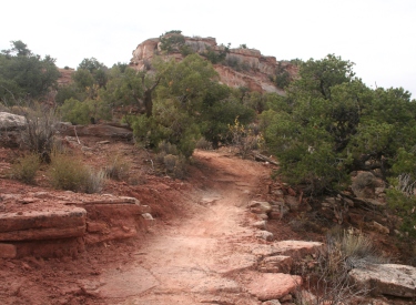
Heading uphill on the Whirlwind Loop |
 |
Highway 313 (Chisholm) Trailhead
The Chilsholm Trailhead is located on Highway 313 about 12 miles from
US 191. It provides access to an easy lariat loop ride (western Chisholm
plus the short Wrangler and Rowdy loops at the Horsethief Campground) and
to the intermediate-technical trails branching off the Mustang Loop
downhill to the east.
For most riders, this will be the preferred trailhead for riding this
area. Eastbound on Chisholm, the Mustang Loop is 0.5 miles downhill. |
 |
Upper Gemini Bridges Road (Getaway) Trailhead
There's roadside parking along the dirt Gemini Bridges road just as
it leaves Highway 313, where you'll find the top of the Getaway Trail. This trailhead is used by riders shuttling the Mag
7 ride (or doing a loop of Bull Run plus Getaway), so it tends to fill up.
The new (as of 2015) upper Getaway singletrack will take you to the handle
of the Mustang Loop in 0.6 miles. Or you can continue on Getaway down to
7-up to enter the Horsethief area from below. |
 |
Horsethief Campground Road
The Chisholm Trail crosses the campground road east of the campground.
There's a small trailhead here.
Campers (and only campers) can enter the trail system directly from the
campground loops. One access leaves the
apex of the eastern camping loop. Wrangler has two connectors, one to the
western end of the east loop, and one at the far west end of the west
camping loop. |
 |
Upper 7-up - Bull Run Trailhead
Riders who want to enter the area from downhill can drive 1.1 miles
down the Gemini Bridges road to the Bull Run Trailhead. From here, pedal
north on 7-up. Your first fork (mile 0.2) will be Getaway, where you can
climb to the handle of the Mustang loop. Further along at mile 1.7 the new
7-up singletrack option will take you to the southern end of Wildcat. Or
you can continue on 7-up to the bottom of Hidalgo at mile 2.5, or the
Whirlwind Loop at mile 3.1. |
 |
Connection via lower 7-up or Navajo Rocks
You can do these loops as a side-ride (or a destination) while climbing
7-up. This route involves substantial climbing to reach the Horsethief
riding area. From the bottom of 7-up on Highway 313, it's 7.1 miles to the
bottom of the Whirlwind Loop. If you drop down to 7-up from Navajo Rocks
on the doubletrack connector (expect some sandy dirt-road riding), it will
be about 4 miles from the southern side of the Navajo Rocks loop to reach
Whirlwind. |
 |
Horsethief Campground Loops
Wrangler and Rowdy
The Wrangler Loop is the easiest trail in the area, suitable for true
beginners and kids. It's 0.7 miles around the loop with virtually no
elevation change. There are two connectors to campground roads, plus a
connection to the eastern loop Rowdy.
The Rowdy Loop has a couple of ledges and a bit of gentle rolling dirt
path, so it's a tiny bit more difficult than Wrangler. But it's still a
very easy 0.5 miles. The eastern side of Rowdy shares 100 feet of trail
with Chisholm, which is your connector from the campground trails to the
main Horsethief system.
[ Go to Horsethief
Campground Trails Page ] |
 |
Chisholm Trail
The Chisholm Trail runs between the Big Lonely portion of the Navajo
Rocks loop and the
Mustang Loop, crossing Highway 313 on the way. There's a trailhead with
parking where Chisholm crosses the road, with the trail descending in both
directions from the highway. It's 7.2 miles long; intermediate;
mostly dirt with some slickrock. West of 313 the trail has 500 vertical feet of
climbing southbound, 200 northbound.
[ Go to Chisholm Trail Page ] |
 |
Mustang Loop
The Mustang Loop is the key to riding the other area
trails. Mustang has connections to Chisholm, Getaway, and the two limbs of
the Whirlwind Loop. Just down the southern limb of Whirlwind is Wildcat,
with Hildago forking off Wildcat. These trails tie the Mustang Loop to
7-up downhill.
Most riders will chose to ride to Mustang from uphill via
Chisholm, or by taking Getaway to the lariat-handle of the loop. There's
300 feet of elevation change from top to bottom. The trail surface is
about 50:50 slickrock and dirt, solid intermediate technical, and rides
well in either direction. The loop is 3 miles, with a 0.2-mile
"handle" on the south that connects it to Getaway.
[ Go to Mustang Loop Page ] |
 |
Whirlwind Loop
The Whirlwind Loop lies on the northeast (and downhill) side of the
Mustang Loop. It shares about 100 yards of the Mustang Loop at the top. At
the bottom of the loop is a short (about 0.1 mile) connector to 7-up.
The loop is 2.2 miles, with about 250 feet of elevation change.
Climbing is mellow in either direction; I liked counterclockwise. The
trail surface alternates slickrock and singletrack, and is intermediate in
technical requirement.
[ Go to Whirlwind Loop Page
] |
 |
Wildcat to Hildalgo Loop
Wildcat forks off the southern limb of Whirlwind about 0.1 miles after
it leaves Mustang. A bit further downhill, Hildalgo forks away (or returns,
depending on how you're riding it). If you combine the bit of Whirlwind
down to Wildcat, Wildcat itself, the northern end of the 7-up singletrack,
a segment of 7-up doubletrack, and Hildalgo as a return climb, it forms a
2.7-mile lariat loop with around 300 feet of elevation change. This route
is a bit more techy than Mustang, but still solid intermediate.
Wildcat is a good route for reaching Mustang if you started riding from
the Bull Run trailhead northbound on 7-up.
[ Go to Wildcat - Hildalgo Page
] |
 |
Getaway
Getaway runs from the upper Gemini Bridges Road down to the Arth's
Corner trail -- where it also meets the downhill end of Bull Run. The
trail is 7.8 miles long with 900 feet of elevation change. It connects to
the handle of the Mustang Loop, and to 7-Up a bit further downhill.
Getaway is significantly easier than Bull Run for timid downhillers,
and it makes a good climbing route. Overall this route is
easier-intermediate.
[ Go to Getaway Trail Page
] |
 |
7-up with 7-up Singletrack
The 7-up trail is the "bottom limit" of the Horsethief riding
area. From south to north, the first connection is to Getaway. Then the
new 7-up singletrack offers a fork to Wildcat. The next connections are
Hildago then the spur to the Whirlwind Loop.
7-up is intermediate in tech requirement overall, but does have some
ledges.
[ Go to 7-up Trail Page ] |
 |
Getting there:
From I-70 and Crescent Junction, drive south on US-191 for 20 miles (about
9 miles north of the Colorado River if you're driving out from Moab) to
Highway 313. Drive uphill 11 miles.
Horsethief Campground Road: On your left at mile 11.8 from Highway
191, turn right on the campground road. 0.1 miles later, turn left into
the Chisholm Trail parking. (Do not park in the campground unless you're
staying.)
Highway 313 Horsethief Area (Chisholm) Trailhead: At mile 12.5, spot the
trailhead kiosk on the left side of the road. Turn into parking. Pedal
east (away from the highway) on Chisholm to intercept the Mustang Loop in
0.5 mile.
Gemini Bridges Road (Getaway) Trailhead: For longer rides of
the area trails. At mile 12.9, turn left at the Gemini Bridges sign. About
200 feet from the pavement, spot a small parking area on your left with
the Getaway Trail just east of parking. Mustang forks away from Getaway
0.6 miles from the trailhead.
Bull Run Trailhead: Drive 1.1 miles down the Gemini Bridges
dirt road, then turn right into the trailhead. Start your ride to the
Horsethief Area trails by heading left on 7up. |
|


