 |
Jackson Hole Loop
The Jackson Hole Loop is one of the meanest little rides in
Moab. Gregg Bromka, author of "Mountain Biking Utah," calls it
"gonzo, abusive, and sick." No argument here. But this loop
offers great scenery, some cool cruising, more than a few riding
challenges, an insane portage, and a gnarly tech downhill. No other ride
in Moab gives you "crazy-biker" bragging rights like Jackson
Hole.
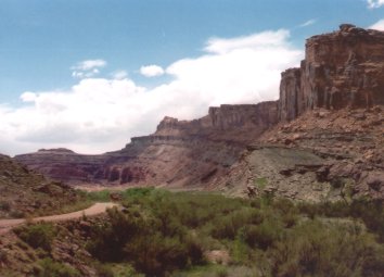
In Kane Springs Canyon, we're looking
at Wingate sandstone cliffs, topped with horizontal layers of the Kayenta
formation. (We've descended below the Navajo sandstone.) Photos April 21,
2003.
|
| The ride is a 22.3 mile loop. Bottom altitude is 3950 feet,
after the plunge from the ridge down to Kane Creek. Peak altitude is 4800
at Hurrah Pass. Total climbing (on the bike) is around 1800 vertical feet,
plus you'll climb 500 vertical on foot while carrying your bike.
Emerging from Kane Springs Canyon, we
see bands of Chinle beneath the Wingate cliffs, with Moenkopi emerging
near the left.
For additional photos of the first
portion of this loop,
see the Hurrah Pass page.
|
|
 |
The first 6 miles are fairly easy technically. On the Hurrah
Pass road, you climb over a pass then drop down to ride along Kane Springs
Creek, with beautiful Wingate sandstone cliffs above you. As you break out
into the open, you pass through the Chinle, then the Moenkopi formations.
We're starting the climb up Hurrah
Pass, through a wonderland of colorful rock.
|
| The climb up to Hurrah Pass is a bit more technical, but
still fairly easy for an intermediate biker. The trail follows a tilted
rock layer within the Moenkopi Formation. Erosion creates a very
interesting pattern to the rock. Take a minute to look around at the top
of the pass, then plunge down the other side.
Goblins and critters litter the slope,
about 1/2 mile from Hurrah Pass.
|

|
 |
Two miles from Hurrah Pass, the ride turns abruptly right in
a wash-bottom, while the road continues straight. (If you go uphill here,
you went the wrong way.) Ride down the wash, keeping right at all forks in
the trail.
View west from Hurrah Pass, with the
Colorado River at left. Rightward from the photo, the potash plant in Shafer
Basin extracts salt from the Paradox Salt dome. See the Geology
of Moab page. Water is pumped in, then the brine is evaporated to
extract salt and potassium.
|
| The riding surface gets progressively tougher. There are
some short but stiff climbs, a few wash dips, and some sand.
There are some spots of odd gray rock here that are like a giant
egg-crate. This rock is tough to tackle uphill, and will rattle your
kidneys right out of your mouth on the downhill.
Yes, those are camels. Do not annoy
them -- they have lots of work to do hauling tourists around the desert.
|

|
 |
Watch for the right turn in a shallow rock-walled wash, about 16 miles into
the ride. If you go straight, it will take you around the left side of
Jackson's Not-Hole (the big rock), through some deep sand. Jackson's Ladder
is on the far side of the rock, in a cleft within the long line of Wingate
cliffs across the valley.
Looking northeast towards Jackson
Not-Hole. The cliffs behind the big rock hold the portage up to Amassa.
|
| The infamous scramble up the cliff is called Jackson's Ladder. This is an almost-straight-up clamber up a rockpile
in a cleft of the vertical cliffs. 500 vertical feet -- 60 flights of
stairs -- over big boulders, while carrying your bike. Keep your helmet
on. The risk of tripping and bashing your head on a rock -- or having a
biker higher up dislodge a rock onto your head -- is substantial. Your
shoulders will ache as you maneuver your bike through the huge rocks.
Looking up, about 1/4 of the way on Jackson's Ladder. The arrow marks where we'll be 1000 groans later.
|

|
 |
After climbing the cliffs above the Colorado River, you roll
the advanced-tech downhill from Amassa Back. This is a great ride, one of
our favorites, with plenty of ledges to launch. You're following the
Kayenta Formation. Plunge through the creek and groan up the opposite
hillside to reach the Amassa Back trailhead. For photos of this portion of
the trail, see the Amassa Back
page.
View west from the top of the portage.
That's Jackson Not-Hole on the left, with the Colorado River on the right. |
Ride notes:
0.0 R and uphill from parking
N 38° 31.717' W 109°
35.802' Alt = 4000'
0.6 Pass Amassa Back trail
0.8 Petroglyph rock on R
1.2 Ridge, 4300 ft, descend switchbacks
2.8 Keep straight, Hunter Canyon on L
6.2 Fork R (L = Kane Springs)
N 38° 27.967' W 109°
36.009' Alt = 4150'
9.4 Summit Hurrah Pass
N 38° 28.919' W 109°
37.509' Alt = 4800'
12.0 Fork R in wash (do NOT go uphill on DT)
N 38° 28.259' W 109°
38.952' Alt = 4050'
12.3, 12.5, 12.9 Keep R |
16.2 Fork R (critical) at cairns in rock wash
N 38° 30.535' W 109° 38.474'
18.2 Fork R to Jackson's Ladder
N 38° 31.413' W 109°
37.595' Alt = 4100'
18.4 Portage up cliffs (mileage break)
Clifftop Alt = 4700'
N 38° 31.614' W 109° 37.713'
18.4 North under power line 200 ft
Trail turns R (east)
18.6 Fork R on Amassa Trail
N 38° 31.723' W 109° 37.678'
21.8 Left (downhill on road)
22.3 Back at parking |
 |
Getting there: Head south on Moab's Main Street. When you
reach the McDonald's on your right, turn right onto Kane Creek Blvd. After
0.6 miles, go
straight where the road seems to turn right. Continue 5
miles until the road turns to gravel, and head uphill about 2/3 mile.
Parking is found at GPS N 38° 31.329' W 109° 35.501', and further uphill
in the official "Amassa Back Parking"
area at GPS N 38° 31.717' W 109° 35.802'. Start the ride by heading up the
gravel road. |
|


