 |
Little Baldy
Southside Timpanogos Great Western Trail (GWT)
This is a mean little climb on nice forested singletrack with views
over Utah Valley from the slopes of Mount Timpanogos. This ride is for advanced
riders who relish strong climbing. Once you hit the singletrack,
you'll grunt up 2000 vertical feet in 3.5 miles. That's a pretty stiff
rate of climb on narrow trail. Seriously, if you're a beginner or
intermediate rider, hike, don't bike.
View south over Utah Valley. Photos
and trail description May 11, 2009 by Bruce.
|
| There are a lot of riding options here. There are four
possible trailheads, six if you count Pleasant Grove and the
Provo Canyon
Raceway trailheads. You can do the trail as a simple out-and-back, or you
can mix it up with one of two loops. |
|
The ride I describe below starts from the most popular trailhead, the
Orem Bonneville Shoreline Trail (BST). It climbs via the least ugly route
to "The Altar" where trails come together, then uphill to Little
Baldy. On the return trip, this route forks on to Trail 51 over to Dry
Canyon and loops back via the singletrack BST for an 11.5 mile ride with
2700 vertical feet of climbing.
For alternative trails in the area, see the area topo map links below
and take the map on your ride.
View of Timpanogos through the trees,
still low on the mountain. |

|
 |
Another loop option, for those who don't mind another 400
vertical feet of climbing, is to continue uphill from the Little Baldy
ridge to intersect the Dry Canyon Trail just below the Big Baldy ridge.
This route involves about a half mile of major steep downhill slop-surfing as the
trail turns into a wash, definitely not for the timid. But after this
short section, the descent down Dry Canyon is fun. This route also returns
via the southbound BST from Dry Canyon to Orem.
We're climbing uphill on the GWT,
downhill from the Altar. This is the route you'd take coming from Canyon
Glen or Nunn's Park. |
| Those who relish a little tougher initial climb can ride the
entire up-and-back on the Great Western Trail (GWT). Start from Canyon
Glenn, or from Nunn's Park. From the Provo River
Parkway paved trail, you'll climb uphill on
the singletrack GWT 033. This section is also
the Bonneville Shoreline Trail, known locally as the Dragon's Back or Razorback.
After a short jaunt on the Orem Bench Road (also the BST) you'll climb Frank's
Trail, officially the Little Baldy GST 033. This trail joins the easier route at
"The Altar" -- a 4-way marked by a big rock pile. Navigation?
Just keep heading uphill.
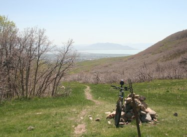
Bruce's bike parked at The Altar,
where three possible uphill routes come together and the GWT continues
alone uphill. |
|
| Because this trail is on the southern slope,
it will clear of snow more rapidly than other high-elevation trails. On
May 11, I found only two short snowdrifts to hike over below Little
Baldy. The first trailside snow I encountered was at 7400 feet. Just after
turning north from Little Baldy, heavy snow covered the trail. To do the
bigger loop uphill to Dry Canyon, I'd wait until June. |
|

|

|
|
After passing The Altar, the trail begins
to wind back
and forth. We're looking east toward Cascade Mountain. |
Butter-smooth but narrow singletrack
alternates
with rocky and loose steep spots. |

 |
The ride I recommend starts at the Orem trailhead. The
doubletrack Orem Bench (BST) heads east into Provo Canyon. The first mile
has a bit of uphill grunting. At 1.4 miles, fork uphill on
singletrack and begin climbing again. This trail is called Betty. Stay on
the main trail -- there are a lot of connections during the first mile of
climbing Betty. At mile 2.6, continue straight past
The Altar, and you're now on the Great Western.
View south over Utah Lake as we begin
to climb the flanks of Timpanogos. |
| Watch for a faint fork on your left, just as the trail is
turning to the right at mile 3.1. Keep right, but note this spot. That's
Trail 51. You'll fork here on the downhill to add the loop into Dry Canyon.
After two more grunting miles of climbing, you'll dip through a ravine,
then climb up to the Little Baldy ridge. For views over the valley, walk
south along the ridge to the top of Little Baldy. Then backtrack down the
trail (or continue uphill for the uglier Dry Canyon descent).
This isn't Little Baldy, but we're
getting closer. |

|
 |
I found a lot of scratchy oak and maple branches intruding
into the trail in the upper portions of the ride. So you might consider
taking arm-warmers and knee-warmers in your backpack, just for scratch
protection during the descent. The downhill isn't that hairy for skilled
riders, but beginners and intermediates have no business here. (Update
2016: It's even more wicked.)
Looking north from the Little Baldy
ridge toward the saddle behind Big Baldy. Our trail intersects the Dry
Canyon trail just below this saddle (you can make out the trail mid-right
in this photo). |
| Once you hit the Trail 51 fork, dip through the ravine and climb slowly
westward. When you hit the trail fork at mile 7.9, keep R uphill and
continue climbing. |
| Trail 51 is a pleasant ride, with little meadows alternating
with groves of trees. Again, stay on the main trail as multiple
singletracks fork away. Trail 51 will climb, then descend, to intercept the Dry
Canyon trail at mile 9.1. Continue downhill to the Dry Canyon trailhead,
then find the Bonneville Shoreline singletrack trail on the south (left)
side of the parking. Head back to Orem.
On Trail 51, skeletons of trees killed
by fire frame the view over Utah Lake.
|

|
Riding Notes: Up-and-back with Trail 51 -
BST Loop
Starts at Orem BST Trailhead
0.0 From parking, find ST BST southeast
N40 19.491 W111 40.135
Alt = up SE on doubletrack
0.1 Join DT
0.8 Ignore 3 branching singletracks
1.4 Fork L uphill on ST (signpost)
N40 19.788 W111 39.342
1.8 Keep R uphill
2.0 Straight, uphill
2.6 "The Altar" 4-way, straight uphill
N40 20.637 W111 39.059
3.1 Faint fork, keep R (L = 51)
Note this spot! You'll fork
here on downhill
N40 20.906 W111 38.961 |
5.1 At Little Baldy ridge
N40 21.583 W111 39.112
Walk to view. Backtrack down
GWT
(Alternate: uphill to Dry
Canyon loop)
7.1 Fork R on trail 51
N40 20.906 W111 38.961
7.9 Fork R uphill
N40 20.627 W111 39.594
8.1 Keep straight
8.3 Keep R
9.1 Fork L down Dry Canyon
N40 20.905 W111 40.079
9.2 Keep L
10.0 At Dry Canyon TH, L to ST BST
N40 20.488 W111 40.575
11.5 At Orem BST TH Parking |
 |
Orem trailhead: Drive towards the mountains on 800 North. At 800 East, turn left and drive north about 1
mile. Immediately past the cemetery, turn right (east) on Cascade Drive just
before the Y in the road and drive 1/2 mile, go up 2 short switchbacks, and
park just above the small brown building in the paved parking area. The
singletrack BST trail starts just south of the lower paved parking. (Look
for the BST sign -- there's another trail across from the upper-level
parking, and it's NOT the one you want.)

|
|
Dry Canyon Trailhead: Turn east off State Street at 200 South in
Lindon, which also happens to be 2000 North for Orem. Keep straight as you
approach the mountains. When the road forks, veer left, then keep straight
uphill. The parking area is at N 40° 20.52'
W 111° 40.62'. From this trailhead, you'll pass through the Orem BST trailhead as you
head toward Little Baldy.
Canyon Glen Trailhead: Use this trailhead for
an all-GWT ride uphill (see map). There are some granny-gear
climbs that are a bit loose. Exit I-15 on Orem's 800 North and drive straight towards the mountains.
Keep left to enter Provo Canyon. About 3 miles later, you'll see the parking area for
Canyon Glen on your left. Go across the bridge to the Parkway. Turn right, and find the
GWT on your left about 200 feet later, forking uphill just before the paved
parkway curves around a rock outcrop. Once you reach the Canal Road, watch for
the GWT singletrack forking R uphill about 1/2 mile later.
Nunn's Park Trailhead: This makes the ride about a mile
longer, but at the expense of a rather ugly short section of trail from Nunn's
park up to the aqueduct. Going up-canyon, turn right 4 miles up the canyon, then
left under 89. Go into Nunn's Park. On your bike, come back through the park
entrance, then turn left on a broken-up roadway just before the road goes under
89. Turn left at the fence and follow the fence uphill. This section is a
hike-a-bike uphill. Downhill, it's tricky because if you slide or bobble you're
going to hit the fence. As the singletrack reaches the top, go left
(down-canyon).
|

|


