 |
Little Canyon Rim
Eagles Nest, Metal Masher
The Little Canyon Rim ride resembles the Golden Spike and
Gold Bar Rim rides, but it's on the opposite (north) side of Little
Canyon. It visits the highest point above highway 191, in an area called the
Eagles Nest. The ride is long, but is big on views and puts great Moab
terrain under your tires.
The ride can be done as a lariat-loop ride from the Gemini
Bridges trailhead. After doing the loop, take a side trip to Gemini
Bridges. As described below, this combination ride is 27 miles with 2200 vertical feet of
climbing. But it's not as hard as it sounds, because 18 of those miles are
on easy dirt road.
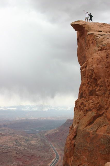
Photo: Chris Hornsby and Jon Peacock on the rim above
highway 191. |
| Some riders do this ride as a downhill point-to-point,
starting on highway 313 (the road to Canyonlands). The distance is about
the same, but there's 1000 feet less climbing. And lots more descending. |
| You
spend 8 miles riding downhill on dirt road before connecting via the
Metal Masher trail near Widow Maker (see map). For this route, most riders
will do the loop clockwise. Navigation can be a little tricky in the
region just before you hit the loop. (2009: missing signs, complex roads
with multiple interconnections, etc.)
Looking east on the Gemini Bridges
road, this is the Gooney Bird. Following trail photos by Bruce. Write-up
May 1, 2009. |

|
 |
If you decide to do the downhill shuttle, I suggest you
download a track file and take your GPS. That will help you find your way
through the mess of branching trails just south of Widow Maker. On the day
I rode, I passed two riders at the Metal Masher fork, and two hours later
I met them again after they'd ridden several circles in the Widow Maker
area trying to find their way out.
View up toward Little Canyon Rim as we
start uphill on Metal Masher. |
|
The out-and-back ride starts from the Gemini Bridges
parking area. First, you'll climb along ridges in the Moenkopi skirts of
the escarpment. Cliff above, cliff below. Up 350 feet in one mile, then a
little drop into Little Valley. Turning west, it's level cruising for a
couple of miles until you hit the Gold Bar Rim turnoff. After forking
right, you'll push your bike up a short hill in loose slop.
Heading counterclockwise up
the loop, rock alternates with dirt.
In rock areas, the trail is marked by white paint spots.
|

|
|

|
The road surface gets firm at the top of the hill,
alternating between grated rock and hard-pack dirt. Keep climbing. Fork
right at the Bull Canyon turnoff to stay on Gemini Bridges road.
Higher up the mountain, 4-wheeler
tires have stained the slickrock. Navigation is easy here. |
|
At 0.8 miles after the Bull Canyon turnoff, fork right,
leaving the Gemini Bridges road. Pass the Metal Masher sign and ride
another 1.2 miles to where Metal Masher forks to the right off the larger
road. A half-mile later, keep right at two trail forks. You should see
paint spots on the rock areas if you're on the right path.
Looking south toward Little Canyon as
the trail continues its climb toward the rim. |

|
 |
After another mile, you'll reach a critical fork. Turn
left 90 degrees. (Straight ahead takes you to an alternate route, and I
don't know where you'll wind up.) Now just follow the tire tracks and dots
up the hill.
Almost to the top. |
| The last 1/3 mile has some tough ledges. Keep climbing. At
the top, you'll arrive at a T intersection. To your right, you'll see the
eagle. First fork right and ride downhill about 0.4 miles to a view area.
This is the eagle, framed against the
La Sal mountains. |

|
|

|
After the viewpoint, turn around and climb back to the T.
Keep straight, riding along the edge of the cliffs. The trail will begin
to descend on rock alternating with dirt. There are multiple little
ledges. Fun stuff.
Looking north, we see skirts of the
Chinle and Moenkopi Formations.
We're standing on ledges of Kayenta sandstone. |
|
As you descend, you'll appreciate that this road would be an easier
climb than the way you came up. If you do a point-to-point from Highway
313, riding up the hill clockwise, this would be your uphill route.
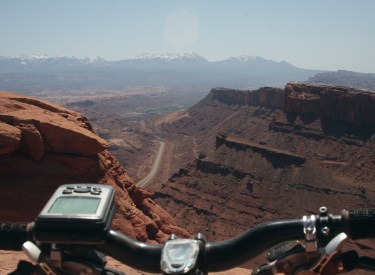
Past the Eagles Nest, we're looking
toward the La Sal Mountains.
The green spot in the valley is Moab. |
|
 |
After a couple of downhill miles, you'll come to an
intersection. The main road is on the left, which is where most riders
will want to go. To the right is the continuing Metal Masher route.
View north as we descend away from the
canyon rim. |
|
If you want to add some additional miles, you can hop on Metal Masher.
But you may wind up going around in circles. I did. But maybe the trail
signs will be replaced for your ride. My GPS track has a few of these back
roads so you can find your way through. Or use the Metal Masher shuttled
ride file and follow it backwards to the Gemini Bridges Road.
Looking north as we continue dropping
downhill. |

|
 |
Assuming you skipped the complex maze of this section of
Metal Masher, keep left past a couple of branching roads. Pass the spot
where you originally headed uphill on Metal Masher. If time allows, turn
uphill on Gemini Bridges road and visit the arches before going back to
your car.
If you venture further on Metal
Masher, you'll come to Widow Maker. This drop is about 8 feet. You can get
up via the rock and ledges to the right. |
Out-and-back loop from 191, with side trip
to Gemini:
0.0 Cross tracks and veer L
N38 39.385 W109 40.667
4.7 Fork R, up sloppy loose hill
N38 36.004 W109 40.404
5.3 Fork R (L=Bull Canyon under arches)
N38 35.807 W109 40.868
6.1 Fork R toward Metal Masher
N38 35.773 W109 41.623
(leave Gemini Bridges Road)
6.9 Keep straight (R) N38 36.207 W109 42.062
7.3 Fork R (L=clockwise loop)
Metal Masher N38 36.525 W109 42.234
7.8 Viewpoint on R N38 36.896 W109 42.030
7.9 Keep R N38 36.944 W109 42.006
8.0 Fork R downhill N38 36.973 W109 41.980
8.9 Fork L (R=alternate)
N38 37.133 W109 41.363 |
9.7 Viewpoint on R N38 37.354 W109 40.964
10.9 Gets tougher
11.3 T - fork R for Eagles Nest
N38 38.204 W109 40.320
11.7 View area, turn around
N38 37.913 W109 40.163
12.2 Back at T, straight (R)
14.3 Keep L (R=Metal Masher)
N38 38.201 W109 42.073
15.6 Straight (R=bailout from Metal Masher)
N38 37.291 W109 42.604
15.7 Keep L N38 37.166 W109 42.728
16.6 Straight (pass Metal Masher entry)
17.4 R to Gemini Bridges
18.8 At Gemini, veer L past viewpoints
Trail N38 35.222 W109 42.600
Backtrack downhill
26.3 Back at parking. |
| An alternative, shorter ride is to drive up
Highway 313 towards Canyonlands and Dead Horse Point, then take your
vehicle down the
gravel Gemini Bridges Road (it's easier to drive down from the top) and
park at Gemini. Do the loop from Gemini, and you'll skip over 12 miles and
a whole lot of climbing. The Gemini Bridges road forks off on the left
about 12.5 miles from Highway 191 at GPS N38 34.412 W109 47.507. |
 |

Getting there: Drive south on US-191 for 22
miles south
of I-70 (about 7 miles north of the Colorado River at the edge of Moab). Spot the parking area on the west (right as you
head toward Moab) side of the road. GPS N 38° 39.381' W 109° 40.672'. Park in front of
the railroad tracks, and head out west on the road toward Gemini Bridges. As
of 2009, a $5 fee is required to park here (it's private land). But you
can park across the road in the Bar M lot, ride south to the tunnel under
191 and follow the paved bike path back to the the Gemini Bridges Road.

|
|


