 |
Little Salty Trail
Little Salty is part of the Klondike Bluffs area trail
complex. It's a
1.7 mile up-down route. Altitude is 5000 feet at the ridge. At the top, it
begins on Baby Steps on a saddle of the ridge. The
EKG Trail transects it
about 0.7 miles from the bottom, where it ends on the Copper Ridge Road.
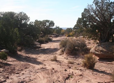
From the top of the ridge, we're
looking west from Baby Steps at the upper end of Little Salty. In the
distance are the Blue Hills. Photos and ride description November 3, 2011
by Bruce.
|
| Most riders will do Little Salty as a downhill. After
reaching the saddle 8.7 miles into the Baby Steps Loop, riders will think
about the ugly continuing climb to the top of Baby Steps. Then they'll
decide that Little Salty is a very attractive trail.
The upper trail is a flattish flood
zone. Note the water channels. As you might guess, this may not the best
way dowhill in a cloudburst.
|
|
 |
The downhill starts with an in-and-out ride down a wash and
flood area. The first half-mile isn't exciting. Depending on recent
weather, it can also be a boulder and gully dodge. It's also a little
harder to be sure you're on the trail in this area.
Once you get out of the flood area and onto the slanted sandstone, it
gets very nice. The trail is well-marked with stripes of yellow paint.
Shortly after reaching the slickrock,
the trail has meandered south and we're looking across the ridge toward
the La Sal Mountains. |
| The trail descends at about 300 feet per mile (6% grade). It
meanders around the tabletop, with some uphill spots during the descent.
A trail called UFO is planned for the future, and it will hit Little
Salty from the left at around mile 0.3 to 0.4 from the top.
The trail slopes down toward the
Copper Ridge road.
|

|
 |
The riding isn't too technical. It's easily within the
abilities of the typical intermediate rider. But if you like, there are
plenty of spots where you can take a more aggressive line. Ledge drops and
some trickier uphill attacks.
We interrupt the downhill to meander
up and around. The trail is well-marked with yellow paint stripes and rock
cairns. |
| At mile 1.0, you'll cross the EKG Trail. Many riders choose
to skip the last 0.7 miles of downhill and head east (left) on EKG. This
is a significantly more technical way to do it, and gives you a little
more workout. This route will take you over to Baby Steps south, where you
can turn downhill to complete your loop.
We've just crossed the EKG trail and
are on the last section of the downhill.
|

|
| Little Salty ends on the Copper Ridge road. Just a bit
north (to your right as you reach the road when descending Little Salty)
is a connecting trail heading west from Copper Ridge. It first connects
to the Jurassic Trail southbound. A bit up
the little hill, it connects to the south end of the Jasper
Loop. These connections offer you additional singletrack that will
take you to other riding options. |
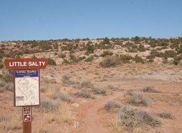 |
As an uphill, Little Salty forks off the Copper Ridge dirt
road 2.6 miles from the cattleguard and parking area of Klondike Bluffs
Road. It starts with about 1/10 mile of dirt and sage, then it hits the
slickrock ramp and starts climbing.
From Copper Ridge Road, the trail is
marked by this sign. |
| The climbing grade is reasonable, mostly middle chainring
stuff. It meanders a bit to give you an occasional break from the slope.
The altitude change is 400 feet over 1.7 miles. There will be an
occasional ledge with a rock ramp -- nothing tricky.
The grade is sustainable, and the
pedaling is easy.
|

|
Sample ride Baby Salty Loop, counterclockwise:
0.0 East across cattle guard
N38 46.417 W109 42.735
0.8 Veer L on Copper Ridge Rd
N38 46.997 W109 43.072
1.7 R uphill on Baby Steps
N38 47.545 W109 43.603
Follow rock cairns up slickrock
2.1 Straight uphill (L = EKG)
N38 47.741 W109 43.285
2.6 Trail veers R N38 48.02 W109 42.88
3.5 Fork L (R= to Klondike) N38 47.958 W109 42.584
3.9 L on ST N38 48.28 W109 42.69
5.1 Back at DT, fork L N38 48.41 W109 42.77
6.1 Fork L to join Klondike trail
N38 48.578 W109 42.373 |
6.2 Keep straight N38 48.656 W109 42.260
6.6 Keep R and descend
N38 48.817 W109 42.085
6.8 Fork L in valley N38 48.811 W109 41.871
8.2 Fork L and climb hill N38 49.310 W109 43.045
8.8 Top of hill, L on ST Little Salty
N38 49.102 W109 43.371
9.0 Future UFO Trail, keep L if fork
9.8 R on EKG Trail N38 48.589 W109 43.922
11.5 R downhill on Baby Steps South
N38 47.741 W109 43.285
11.9 L on Copper Ridge Rd
N38 47.548 W109 43.605
12.9 Keep R at road fork
13.6 Back at parking |
 |
Getting there: Starting at the Colorado River, drive
15 miles north from Moab. Look for a turnout with parking on the right and
a sign for Klondike Bluffs Road. There will
usually be cars parked there (GPS N 38° 44.452' W 109°
44.037'). For a longer ride, park here and ride up the road.
Most cyclists will choose to go through the gate and drive 2.7 miles. Keep left at
the fork. At 2.8 miles, park your car in the broad parking area by the
fence. Go eastbound across the cattleguard through the fence and begin your ride.
Note: Trails are color-coded to show individual named
trails. The Baby Steps route in red does not correspond to the loop ride
above.
|
| Northern Klondike TH: On Highway 191 8.5 miles
south of I-70 and 6.5 miles north of the southern Klondike Bluffs road
(about 5 miles north of the airport), watch for a "Northern
Klondike" sign at N38 49.504 W109 46.893. Turn east (toward the
sandstone bluff). Keep to the right as the road winds south around a small
hill. 1.2 miles from the highway as the road is heading east toward the
bluff, fork right on a fainter jeep road N38 49.103 W109 46.061, as the
main road continues to the dinosaur tracks. (Park here if the road is in
bad shape.) At mile 1.6, you'll come to the TH for the Jasper and Agate
loops (N38 49.087 W109 45.625) on your right. At 2.0 miles, you're at the
bottom of Mega Steps at a larger parking area N38 49.179 W109 45.417.
To reach the bottom of Little Salty, ride south on Copper Ridge for about
2 miles. The top of Little Salty lies on the uphill side of Baby
Steps. |
|


