 |
Longview Trail
with Turkey Road and Peacemaker
The Longview trail lies on the Alpine side of Draper's Corner
Canyon/Traverse Ridge trail system. Longview extends from the lower Hog
Hollow trail (right at the end of Fango and Achtung
Baby) up to the newer Peacemaker trail. Most riders are using Longview
(and Peacemaker) to climb to the Peakview
trail. The expected riding season is late May through November.
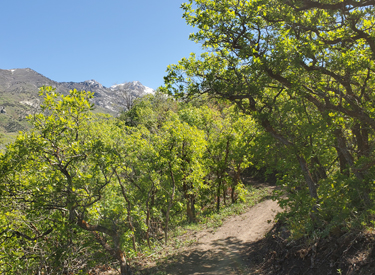
Heading northeast through tall oak groves while
climbing the Longview trail. Photos and trail review by Bruce on May 27,
2021.
|
| New in late 2020, Longview is primarily used as a climbing
route, often combined with Porcupine and Achtung Baby for a loop ride.
The elevation at the bottom of Longview is 5250 feet. It climbs at a
gentle pace to end on Peacemaker (see below) at 6250. Longview and
Peacemaker are suitable for
strong beginners, but loop rides and further exploration at the top
require intermediate skill or better.
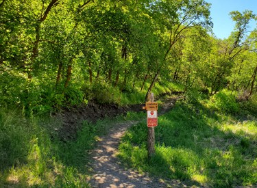
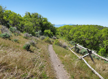
Entry to Longview from the Hog Hollow trail. It's a
150-degree turn to your right when climbing Hog Hollow, but a straight
shot if you're coming from uphill (from Fango or Achtung Baby). |
|
 |
From the valley, Longview can be reached by climbing Hog
Hollow Creek to Hog Hollow. (Or starting at Angel Gate trailhead for Hog
Hollow.) Or, you can traverse from the south Maple Hollow trailhead via Woods
Hollow then Fango. Or descend from Peakview
via Achtung Baby. Longview begins just across Hog Hollow from Fango and Achtung
Baby.
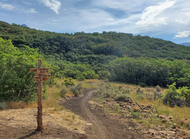
You can arrive at the top of Turkey Road and Peacemaker by climbing Peakview from
Corner Canyon. These trails connect to Longview just downhill. The closest trailhead in Corner Canyon is the Peakview trailhead
where the Peakview Trail starts. Or you can get there by climbing Three
Falls from Alpine.
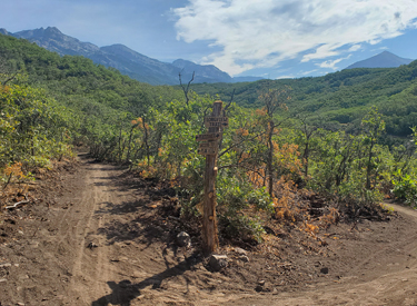
Early in the climb. That's Timpanogos just behind the
first row of Wasatch Front hills. |
| Longview is 3.2 miles in length. The
singletrack is a smooth bench-cut with a gradual but steady rate of climb
(around 200 vertical feet per mile). At mile 3.0 of Longview, you can
continue the climb on the Turkey Road trail, which is an old abandoned
dirt road, or you can veer left and stay on Longview for another 0.2 miles
to reach Peacemaker. (Peacemaker connects to Porcupine on the west and to
Peakview on the east.)
Heading northeast toward Lone Peak and Ram's Horn. |

|
 |
The Longview trail is an easy ride and is suitable for
beginners. Most true beginners will want to do Longview as an
out-and-back, as other descending routes require intermediate skill.
The terrain is groves of oak with small meadows. To the northeast,
there will be frequent views of Lone Peak. To the east is Box Elder peak.
The view southeast features the Wasatch Front with Timpanogos just behind.
To the south is Utah Valley, with views over the lake.
Looking southwest. The little white strip next to the
water storage reservoir is Angel Gate parking. At the top of the photo are
Utah Lake and Lake Mountain. |
The rides you'll find at the top require at least intermediate skills.
From the top of Longview, Turkey Road and the eastern side of Peacemaker
end at the same spot on Peakview. Here a right turn will take you to the Jacob's
Ladder access trail and to the Three Falls trail.
Near the top, with around 1/2 mile to go before
Turkey Road. The trail winds in and out of multiple small canyons. |

|
 |
A left turn on Peakview offers lots of ride options. Many
riders are choosing a loop ride, descending Peakview to take Porcupine
downhill, then crossing upper Hog Hollow to Achtung Baby for the rest of the
descent back to the bottom of Longview.
If you're descending Peakview and bypass Porcupine, it will
deliver you to the big Peakview trailhead (bathrooms, tools, etc!),
where you can connect to Clark's, Canyon
Hollow, Rush, and Ann's
trail.
On the new (2021) upper end of Longview, heading
toward the Peacemaker trail. |
| Another (fun but longer) loop option goes to the east. This
loop combines Hog Hollow Creek, Longview, Three Falls, Fort Canyon, and Vista
Ridge. At the bottom, there's a 2.1-mile road return on city streets
in Alpine to tie Vista Ridge back to Hog Hollow Creek (the entry on
Westfield Road is unmarked but easily spotted).
View from the top. That's Box Elder Peak on the
right; Lone Peak, Ram's Horn and Chipman Peak on the left.
|

|
 |
Turkey Road is an alternate trail at mile 3.0 of Longview.
This final 0.5 miles of the climb to Peakview is singletrack on the grade of the old dirt road
called Turkey Road. (Vehicles are no longer allowed here.) If you elect to
use Turkey Road, your climb will have steeper sections of around 10% slope. Not horrible at
all, but you might have to hit your granny gear.
Turkey Road reaches Peakview at the same spot as Peacemaker. It's a
shorter option (0.5 miles vs 0.9 miles), but at the price of stiffer
climbing.
Here's Turkey Road. Pretty mellow at first, but it
gets steeper! |
 |
The Peacemaker Trail is 1.0 mile in length, with 250 feet of
elevation gain from west to east. The trail is a smooth bench-cut suitable
for beginning riders. The trail is new in 2021.
If you're coming from the Peakview trailhead, Peacemaker forks left
from Porcupine at mile 0.2 after Porcupine's uphill origin on Peakview.
Looking east at Peacemaker from the Porcupine trail. |
| After climbing to the top of Longview from Hog Hollow, a
left turn will take you 0.3 miles on Peacemaker directly to Porcupine.
This offers a shorter version of the Achtung Baby loop ride with 250
vertical feet less climbing. At this time -- July 2021 -- most riders are
still choosing to climb uphill to Peakview instead of doing the shorter
loop that bypasses the Peakview trail.
Typical trail surface: undulating bench-cut in a
forest of scrub oak.
|

|
 |
A right turn at the top of Longview onto Peacemaker leads
you to the Peakview Trail near its highest point. It will be 0.7 miles and
a bit over 200 vertical feet of climbing.
Looking east from Peacemaker at the trail fork where
Longview ends. |
| From this spot, Three Falls and the Jacob's Ladder connector
are reached by turning right (east).
A left turn puts you westbound on Peakview, where you'll immediately
hit the last little bit of climbing. Then the Peakview trail descends west
either to the Porcupine trail or the Peakview trailhead.
Much of Peacemaker is shaded with tall oak.
|

|
 |
Bottom Line:
A great addition to Draper's south-side trail system, nicely built and
easy to ride. Intermediate riders will enjoy the Longview-Achtung Baby
loop.
On the bigger version of the loop ride. We've descended the first half of Peakview to reach
Porcupine. We're headed for Achtung Baby -- right across Two Hollows from
the lower end of Porcupine -- for the loop ride. |
Riding notes, Longview to Achtung Baby loop from
Angel Gate:
0.0 Exit parking northbound on Hog Hollow Creek
Quickly turn left in the dip
0.1 Left on Hog Hollow
0.4 Hard right onto Longview
3.5 Straight on Turkey Road = faster climb
4.0 Left on Peakview
4.8 Hard left onto Porcupine
5.7 Cross Hog Hollow to Achtung Baby connector,
150 feet, then left to descend.
6.0 Hard R on Two Hollows
6.1 Left on Achtung Baby
7.4 R on Hog Hollow
7.8 Back at trailhead |

|
 |
Getting there:
Angel Gate at Spring Hollow (upper Hog Hollow and top of Hog Hollow
Creek): On Westfield Road, turn uphill (north) on Beacon Hill Blvd.
Drive 0.5 miles, then as Beacon Hill turns to the right (east), turn left
on Lighthouse Drive to continue straight north uphill. Lighthouse will
become Angel Gate. Keep straight until you pass the irrigation facility,
then park. At the northeast corner of the fence, a doubletrack descends
east across the hollow. Immediately after crossing the creek, turn left on
Hog Hollow.
No water or restrooms at Angel Gate.
For other nearby trailheads, see the pages for Woods
Hollow, Eagle Crest, Peakview,
and Fort Canyon.
|
|


