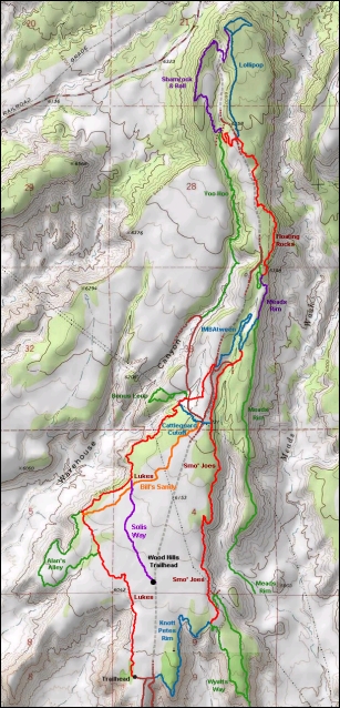
 |
Wood Hill Trails
(Luke's Trail area)
The Wood Hill mountain bike area is the highlight of Price's biking.
There are 20 miles of trail on this mesa, with tons of different riding
combinations. The Wood Hill trailhead starts your riding on Solis Way, just
3/4 mile from the north edge of town. Or you can stash the spouse and kiddies at Pioneer Park and ride directly
from town.
Trails are listed in alphabetic order. |
 |
Alan's Alley (side ride off Luke's)
Alan's Alley is 1.3 miles in length, leaving Luke's for a meander
along the edge of the mesa before rejoining it 1/3 mile north of its
origin. It's a tad more technical than early Luke's, but still easy
riding. See Luke's trail page for riding
instruction and photos.
Bonus Loop (side ride off Luke's)
The Bonus Loop forks off Luke's near the upper end. It's a
lariat-shaped ride of 0.7 miles. The wash-crossing to get to the loop is
tough, but the loop itself is intermediate. The loop skirts the mesa edge
for views to the west. See Luke's trail page for
riding instruction. |
Bill's Sandy
Bill's Sandy is 1.2 miles, designed to ride east to west. The eastern
end begins on Dick's Cutoff (Cattleguard Cutoff below). and the western
end is on Luke's. The riding itself is quite easy. There are some man-made
stunts for fun.
[ Bill's Sandy page
] |

|
 |
Cattleguard Cutoff (Dick's Cutoff)
This short route (0.3 miles) connects the cattleguard near the end of
Luke's to the cattleguard on Smo' Joes at the east border of the mesa. The
western 0.2 miles is ST; the last 0.1 mile is DT. The primary use for this
trail is to cut across between trails for a shorter loop ride -- or varying ride combinations.
See Luke's trail page for riding instruction and GPS coordinates. |
| Devils Backbone (with playground)
Devils Backbone is a short ridge forking off the eastern end of the
Wyatt's Way loop on the far southeast corner of the mesa. It descends to a
playground. Used as a loop by climbing the mesa road to Knott Pete's Rim,
then taking the southern side of Wyatt's Way to the backbone. It will drop
you to the edge of town.
[ Knott Pete's to Wyatt's Way page
] |

|
 |
Floating Rocks
Floating Rocks is a north-south trail that can be done in either
direction. On the downhill (southern) end it begins by forking off the
northern end of Mead's Rim. It extends up to the beginning of Lollipop,
with a continuation down to the intersection of the downhill end of
Shamrock & Roll with the top of Yoo Hoo. It's 1.1 miles to Lollipop;
1.3 to Yoo Hoo.
[ Floating Rocks Loop page ]
[ Yoo Hoo Loop page ] |
| IMBAtween
IMBAtween is singletrack that connects the top of Luke's Trail with the
northern end of S'mo Joes and with Mead's Rim. It's a bit more technical
in spots. This segment is 1.1 miles long.
[ Smo' Joes Loop page ] |

|
 |
Knott Pete's Rim
Knott Pete's Rim follows the southern edge of the mesa above the
neighborhoods of northern Price from the Kenilworth road near the Luke's
trailhead. It's 1.3 miles long. The trail is most-commonly used
east-to-west as a return path from various loop rides. It's also done
west-to-east to get to Wyatt's Way and Devils Backbone for a
town-to-mesa-to-town loop.
[ Knott Pete's to Wyatt's Way page ] |
| Lollipop
This is a lariat or lollipop ride forking off the northern end of
Floating Rocks. The top of Shamrock & Roll forks off the little loop
at the end of the trail. The northern end of the trail overlooks the town
of Kenilworth along the Book Cliffs. The trail is 1.1 miles long.
[ Floating Rocks Loop page ]
[ Yoo Hoo Loop page ] |

|
 |
Luke's Trail
Luke's Trail was the first trail on the mesa, and is still the key to the
riding area. Luke's is reached via Solis Way from the Wood Hill trailhead,
or you can start at the south end at the old trailhead. It ends on the Kenilworth Road.
The IMBAtween trail is a continuation just across the road. Side rides on
Luke's include Alans Alley and Bonus Loop.
[ Luke's Trail Page ] |
| Mead's Rim
Mead's Rim is 2.5 miles in length, descending from the Kenilworth road
and dropping off the mesa north of Price. The trail is advanced technical
overall. Upper Mead's has connections to Floating Rocks and IMBAtween. The
last portion of Mead's has a hairy descent. (Mead's will take you OFF the
mesa.)
[ Mead's Rim Page - NOTE: update
pending! ] |

|
 |
Shamrock & Roll
Shamrock & Roll lies at the northwest tip of the mesa. From the
northern end, it descends from Lollipop, goes through a valley, climbs to
another ridge, then descends again to the top of Yoo Hoo. It's 1.3 miles
long.
[ Floating Rocks Loop page ]
[ Yoo Hoo Loop page ] |
| Smo' Joes
Smo' Joes follows the eastern side of the Mesa. The northern end forks
off IMBAtween about 0.8 miles from the top of Luke's. It ends on the south
at the intersection of Knott Pete's Rim with the southern limb of Wyatt's
Way. It's 2.1 miles long.
[ Smo' Joes Loop page ]
[ Floating Rocks Loop page ]
[ Yoo Hoo Loop page ] |

|
 |
Solis Way
Solis Way extends 0.8 miles from the Wood Hill trailhead parking lot to
the middle of Luke's Trail. Mostly winding singletrack in sage brush, but
it's your way to the trail system. Easy riding.
[ See Luke's page ] |
| Wyatt's Way
Wyatt's Way is a loop on the southeast corner of the mesa, with views
over Price. It can be a side loop off a bigger loop ride. More commonly,
it's combined with Knott Pete's Rim for a route from Price to Devils
Backbone. The full loop is 1.7 miles.
[ Knott Pete's to Wyatt's Way page ] |

|
 |
Yoo Hoo
Yoo Hoo is a DH trail that's kind of "a work in
progress." After the first half mile, it drops into a wash and becomes more
primitive (unless trail-buffing has improved it. It begins as a continuation of the southern end of
Shamrock & Roll and descends to a pump road 1.5 miles later. Fork left
the pump road to climb back to where Luke's crosses 0.5 miles later.
[ Yoo Hoo Loop page ] |
|
|
Getting there, Wood Hill trailhead parking: Eastbound on US 6, take the
first Price exit. Turn left and enter town on 100 North. About a mile
after leaving the freeway, turn left (north) on 300 East. Drive to 900
North and turn left. The road will turn to dirt and/or narrow asphalt, and
will veer right and climb the mesa. As you reach the top of the mesa
1/2 mile later, continue straight north for another 1/2 mile. The gravel
trailhead will be on your left. Solis Way begins across the doubletrack
from the northwest corner.
Getting there, southern Luke's primitive parking: Eastbound on US 6, take the
first Price exit. Turn left and enter town on 100 North. About a mile
after leaving the freeway, turn left (north) on 300 East. Drive to 900
North and turn left. The road will turn to dirt and/or narrow asphalt, and
will veer right and climb the mesa. One-half mile later at the top
of the mesa, just after you've passed the buried water tank, fork left (west) and proceed 0.1 mile to the Lukes parking
area.
Getting there, Pioneer Park (classic Luke's start or Mead's Rim
return): Enter
Price as above. About a mile
after leaving the freeway, turn left (north) onto 100 East. Go four city
blocks to the far end of Pioneer Park, turn right onto 500 North and find
a parking place. The ride starts at the corner of 100 East 500 North.
You'll be riding west (towards the water tank).
Camping: Primitive sites just southwest of the the old Luke's trailhead
Water: None at trailhead.
Bathrooms: Wood Hill trailhead, Pioneer Park in Price
Bike services: Price

|
|


