 |
Mill D North Fork
The Mill D North Fork trail is a tad on the technical side,
with many roots and embedded rocks. It's also a fairly stiff rate of
climb. So it's best for strong-intermediate
or advanced riders. It's a great downhill, but a bit of a beast to climb
up.
Although the ride is mostly in forest,
there are occasional eye-popping views of the Wasatch peaks. Here we're
looking south. Original review June 16, 2002 by Bruce,
with additional photos and new trail information July 2022.
|
| Most riders ride Mill D North Fork by dropping off the
Wasatch Crest trail above Desolation Lake. This is a popular option on
odd-numbered days, when upper Mill Creek is closed to bikes.
But
the uphill is nice and has some fun riding options -- for example the
little loop on the Big Cottonwood side of Dog Lake -- if you've got the leg for it.
Descending Mill D through luxurious ferns and
wildflowers. |

|
 |
The top of Mill D North Fork is at 9100 feet elevation on
the Wasatch Crest trail. Although much of the trail faces south, it's
deeply forested and doesn't clear of snow until mid-June. The usual riding
season is July through early October.
View uphill as Mill D hits a meadow. We're between
the two Dog Lake connector trails.
|
 |
The Mill D North Fork trail starts at a trailhead at
Reynolds Flat in Big Cottonwood Canyon. The parking is on the left side of
the road at mile 8.8 from the traffic light at the bottom of the canyon.
The trail starts on the downhill side of the parking strip.
Trailside view to the south at the Cottonwood Ridge.
|
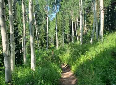
| The lower half of Mill D is a forested ride, in quakies with
occasional fir. The upper half rolls past a few meadows, with
occasional views of nearby mountains. There are lots of wildflowers in
summer. It's a very pretty ride.
Mill D North Fork is very popular with hikers. On a
Saturday, you'll need to be extra careful. Be considerate of other trail
users.
Looking west downhill on a mellower section of Mill
D.
|
|
 |
As you get higher in elevation, more of the forest becomes
fir, with a few open meadows. During the first 1.9 miles up to the Dog
Lake trail fork, you'll climb around 950 vertical feet.
Looking up at the ridge of the Wasatch Crest, our
ultimate destination on a bigger ride.
|
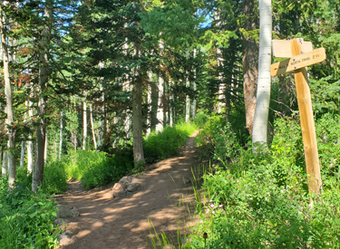
| At mile 1.9, you'll reach the trail fork for the Dog Lake to
Mill D Connector trail. This trail climbs 0.8 miles up to Dog Lake with
400 vertical feet of elevation change.
Keep to the right to climb higher on Mill D.
At the first trail fork. Straight ahead is Mill D; to
the left of my bike is the Dog Lake to Mill D Connector.
|

|

|
There will be some steep and moon-dust slippery stretches,
with embedded rocks and logs as water-control bars. Depending on recent
maintenance and your leg strength, there may be some brief hike-a-bikes.
Smoother trail sections give you a
breather. Here we're crossing a shallow creek in typical aspen and fir forest.
|
| At mile 2.7, you'll hit the trail fork for the Dog Lake to
Desolation Connector trail. Keep right to continue climbing Mill D.
The Dog Lake to Desolation Connector is 0.9 miles long with 100 feet of
climbing. It can take you to the southeast corner of Dog Lake, where it
joins to the Dog Lake to Mill D Connector trail.
The trail fork for the Dog Lake to Desolation
Connector, seen from uphill.
|
|

|
At mile 4.0, you'll pass the northern shore of Desolation
Lake. This is one of the highlights of the ride.
Here we are at Desolation Lake. Take a
victory lap. Desolation Lake is an example of a glacier lake, formed
within a cirque dug by the moving glacier. When the glacier melted (around
10,000 years ago), the depression filled with water.
|
| If you continue uphill past Desolation Lake, it's a bit less
than 1/2 mile up to the Wasatch Crest trail at mile 4.4 from the
trailhead. You will have climbed 1900 total vertical feet.
Here's Dominic around the year 2000 on the Spine of
the Wasatch Crest above Desolation Lake. |

|

|
On your way back down, consider a side trip via the Dog Lake
to Desolation Connector to visit Dog Lake, then drop back via the Dog Lake
to Mill D Connector before continuing on down to the trailhead.
Rolling through aspen and fir forest
|
 |
Loop 1: Most
bikers ride a loop by climbing the paved road from the trailhead. Turning
left onto the Guardsman Road, they ride to the Wasatch Crest trailhead and
climb Puke Hill. Just past the Desolation Lake overlook, the trail forks
left to drop down past the lake. Keep left at the Dog Lake trail
intersection. This gives 4 miles of kick-butt downhill. Total climbing is
2700 feet, distance 16.7 miles. To avoid the road ride and 1700 feet of climbing, you can leave
a shuttle at the Mill D trailhead and drive up to the Wasatch Crest
trailhead. [GPX Track]
The trail is a great downhill ride,
but a little rough in spots for beginners.
|
| Loop 2: A fun but
challenging loop option is to ride Mill D uphill, climb to the Wasatch
Crest, then turn left and ride down the Great Western in North Mill Creek.
After descending a few miles, we keep left at the trail intersections to
climb up past Dog Lake. Here are two options: left for 1/2 mile steep and
gnarly, or right for a mile of nice trail to Mill D North. We turn
downhill on Mill D to complete the loop. The climb to the Crest is 2400 feet. Add another 400
feet of climb to get back past Dog Lake. Distance 12.5 miles. [GPX
Track] NOTE: Upper Mill Creek trails are
CLOSED to bikes on odd-numbered days!
Here's a bit of that rough trail. Log
water-bars, roots, and rocks make it interesting.
|

|
 |
Out-and-back: As
an out-and-back to Desolation Lake, the trail is 3.8 miles each way, with
a gain of 2000 feet. Starting elevation is 7300 feet. Add in a ride around
the lake, and you've got a total of 8 miles. This option, and the Mill
Creek loop option, are for strong climbers with good root-hopping skills.
[Mill-D-N Track]
Descending Mill D North as the trail approaches
a log waterbar.
|
| Epic Loop:
For a truly worthy ride, head up-canyon on pavement to the Wasatch Crest
as in Loop 1 above. But instead of dropping down the Desolation Lake
Trail, continue north on the Wasatch Crest. Descend down the north side of
Mill Creek, and when you hit the Dog Lake trail. Climb 400 feet back
uphill.
Ride past Dog Lake, then descend the Dog Lake to Mill D Connector. Turn right on Mill D after descending from the
lake. Distance 21.5 miles. [GPX
Track] NOTE: Upper Mill Creek trails are
CLOSED to bikes on odd-numbered days.
Arriving at Dog Lake from the Connector trail. |

|
Riding Notes, Desolation and Dog Lake
Loop:
0.0 From parking north up ST Mill D North
N40 38.672 W111 38.412
1.6 Stay R on Mill D North (L = Dog Lake)
N40 39.759 W111 37.791
3.9 Pass Desolation Lake
4.1 L on Wasatch Crest
N40 39.507 W111 35.794
6.5 Keep L, downhill on Mill Creek Trail
N40 41.224 W111 36.087 |
(R
= to Midmountain Trail)
7.6 Keep L N40 40.975 W111 37.177
9.5 L uphill at 4-way (to Dog Lake)
N40 40.694 W111 38.514
10.4 Pass Dog Lake
11.0 R downhill on Mill D North
N40 39.759 W111 37.791
12.5 Back at parking |
 |
Getting there: Go to Big
Cottonwood Canyon (Wasatch Blvd and 72nd South) and drive 8.8 miles up from
the traffic light. Park near the trailhead on your left. GPS N 40°
38.976' W 111° 38.884'.
Guardsman Pass trailhead: Ride up the road past Solitude Resort (about
6.5 miles). Just before you reach Brighton, the road to Guardsman Pass turns off on your
left. Exactly one mile later (1.8 miles from
the fork in the road), you'll see a dirt road on the left. GPS N 40° 36.817' W 111°
33.532'. Park along the hairpin turn and bike up the road.
|

|


