
|
Miner's Loop
Miner's Loop is a short loop that begins on the southern end of the EKG
trail in the Klondike Bluffs riding area
north of Moab. The loop is 1.9 miles long with 300 vertical feet of
climbing. The riding is upper-intermediate to advanced technical.
Additional riding options from Miner's Loop include Azurite
and Malachite as an extension of the loop, or as a connection to Baby
Steps.
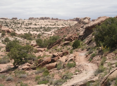
View southwest from the top of the
ride. The faint band at mid-left is the Klondike
Bluffs trail. Photos and GPS track May 21, 2014 by Bruce.
|
| To ride Miner's Loop, it's easiest to start from the
southern Klondike Bluffs trailhead. Ride Inside
Passage to the Klondike Bluffs main trail.
At the Copper Ridge fork, keep straight onto the singletrack Dino
Flow. At the next fork, go to the right uphill on EKG.
Then a tiny bit later, fork right uphill again on Miner's Loop. The trail
system is well-marked, with maps on trail posts. While the route sounds
complicated, you can find this trail easily even if you don't you know your way around.
View west from the beginning of
Miner's Loop. This shows the relationship of the trails you'll need to
take to get here.
|

|
 |
I'll describe the route from the southern Klondike parking
area (see below). Once you've completed the loop, the remaining ride is up
to you. The full ride I describe here is a quick but tough loop from Mega
Steps parking, taking EKG southbound to Miner's Loop and returning via
Dino Flow.
This is the beginning of Miner's Loop
as it forks off EKG. EKG has orange slashes. Miner's Loop is marked with
red-purple. Note the trail sign with its map. |
| Just 100 yards from the trail's beginning, the loop begins.
The recommended riding direction is counter-clockwise. This puts the dirt
singletrack on the climb, with most of the technical rock on the downhill.
The trail is marked with purple slashes on open-rock areas.
The loop splits. Right is more fun.
But you're allowed to go either direction. Left will give you a
tough and techy climb, and on weekends you might be dodging
poorly-controlled downhillers.
|

|
 |
The trail is about half dirt singletrack and half sandstone. The loop has a bit more dirt singletrack than other trails
on the eastern side of the Klondike area. Because of the climbing and
technical riding, it will seem longer than its 1.9 miles.
Juniper and pinion grow where dirt separates the humps of Salt Wash
sandstone. There will be a few cacti and paintbrush blooming in May.
The pink species of prickly pear
cactus.
|
| After the first zone of rolling rock on singletrack, the
climb settles into a winding route on dirt. Don't get too excited about
the large areas of open sandstone you see uphill -- you won't be going
there.
Heading eastbound as we climb the
southern side of the loop.
|
|
 |
You'll pass the mine of Miner's Loop after about half a
mile. There are several abandoned copper and uranium mines in the Klondike
area. The mines have been sealed to prevent idiots from hurting
themselves, but explore at your own risk.
Moab has old mines in almost every
side canyon.
|
| As you gain altitude, you'll begin to get some views. You'll
see hints of Klondike Bluffs on the skyline to the east, and the La Sal
Mountains to the southeast. There will be views across the valley to the
west.
At about mile one of the loop, looking
east as we climb a ridge.
|

|
 |
At one mile into the loop, the Azurite trail forks to the
right. Taking this trail (and Malachite as a return to the loop) will add
about two miles to your ride. See the Azurite/Malachite
trail page for details about these newer trails.
Riders navigate the last couple of
climbing turns. After climbing on the south side of the ridge, the trail
goes around the east end of the ridge then approaches the ridgeline from
the north. |
| The highest point of Miner's Loop comes 1.2 miles after
entering the loop. You'll climb around a ridge then up to the top. The
climb is steady and non-brutal, with nothing tricky so far. (As you
descend, you'll see why the counterclockwise route is recommended. It's a
bit techy.)
Take a break at the summit. It's worth looking around a bit.
Once you start downhill, you won't be seeing much but the sandstone ahead
of you.
Looking over the Salt Wash sandstone
toward the La Sal Mountains. |

|
 |
From the summit the trail descends west over slickrock.
There are occasional slightly-steep spots, but no sudden plunges. You'll
drop 300 feet in just over 1/2 mile. There will be a few rough spots, and
one section of wheel-traps for 26-inch wheels. The downhill trip is fast,
and will be limited only by your tech-riding skills.
Beginning the downhill section on
rolling slickrock. |
Miner's Loop from South Klondike
Trailhead:
0.0 ST at N corner (Inside Passage) N38 46.433 W109 42.765
0.4 Join main Klondike northbound N38 46.689 W109 42.901
0.7 Stay R on Klondike (ST on L = Jurassic) N38 46.866 W109 43.064
0.8 Through sandy wash N38 46.913 W109 43.073
0.9 Straight onto Dino Flow ST N38 46.997 W109 43.072
1.1 R onto EKG N38 47.116 W109 42.983
1.3 R on Miner's Loop N38 47.167 W109 42.940
1.4 Keep R for counterclockwise loop N38 47.170 W109 42.916
2.3 L (R = Azurite) N38 47.419 W109 42.449
2.45 L (R = Malachite) N38 47.496 W109 42.540
2.5 Top of ridge (4925 ft)
3.2 Keep straight (close loop) N38 47.170 W109 42.916
100 yards to EKG N38 47.167 W109 42.940
R to continue EKG north, L for Dino Flow
Looking west as we hit a smooth ramp
of sandstone. |

|
Sample loop ride: EKG - Miner's -
Dino from Mega Steps TH
0.0 East on Mega Steps N38 49.180 W109 45.414
0.3 Join Dino Flow uphill (keep R) N38 49.419 W109 45.043
100 feet, then L on Mega Steps
0.5 R on EKG (L = Alaska, Str = Mega Steps)
N38 49.419 W109 45.036
1.4 Join North Baby Steps downhill N38 48.973 W109 44.612
100 feet, then L to stay on EKG
2.8 Cross Little Salty N38 48.596 W109 43.913
4.5 Cross South Baby Steps N38 47.747 W109 43.289
5.2 Join Dino Flow to cross wash (keep L)
N38 47.374 W109 43.261
After wash fork L uphill for
EKG
5.8 L on Miner's Loop N38 47.167 W109 42.940
100 yards, then R on loop N38 47.173 W109 42.916 |
6.8 L (R = Azurite) N38 47.419 W109 42.449
6.95 L (R = Malachite) N38 47.496 W109 42.540
7.0 Top of mountain
7.7 Close loop, keep straight N38 47.173 W109 42.916
100 yards, then L on EKG N38 47.167 W109 42.940
7.9 R on Dino Flow N38 47.115 W109 42.981
8.4 Cross wash, keep L on Dino N38 47.370 W109 43.250
8.8 Cross South Baby Steps N38 47.593 W109 43.557
10.0 Cross Little Salty N38 48.248 W109 44.150
11.3 Cross North Baby Steps N38 48.900 W109 44.715
12.1 Keep L joining Mega Steps N38 49.355 W109 45.171
100 feet, stay L on Mega Steps
12.5 Back at parking |
 |
Getting there, main (southern) Klondike Bluffs
trailhead: Starting at the Colorado River, drive
15 miles north from Moab. Look for a turnout with parking on the right and
a sign for Klondike Bluffs Road. There will
usually be cars parked there (GPS N 38° 44.452' W 109°
44.037'). For a longer ride, park here and ride up the road.
Most cyclists will choose to go through the gate and drive 2.7 miles. Keep left at
the fork. At 2.8 miles, park your car in the broad parking area by the
fence. Begin your ride eastbound across the cattleguard, or hit the
singletrack Inside Passage in the northern corner of the parking area.
Water: None
Toilet: Dinosaur Tracks parking
Camping: Not here
Information: Moab visitor's center

|
Northern Klondike Trailheads: On Highway 191 8.5 miles
south of I-70 and 6.5 miles north of the southern Klondike Bluffs road
(about 5 miles north of the airport), watch for a "Northern
Klondike" sign at N38 49.504 W109 46.893. Turn east (toward the
sandstone bluff). Keep to the right as the road winds south around a small
hill.
Chilkoot Pass parking: 1.2 miles from the highway as the road is heading east toward the
bluff, the first parking zone is on your right. This is the Chilkoot Pass
trail.
Agate trail parking: Continue a few feet past the Chilkoot
parking. Fork right on a fainter jeep road N38 49.103 W109 46.061, as the
main road continues to the dinosaur tracks. At mile 1.6, you'll come to the TH for the
Jasper and Agate
loops (N38 49.087 W109 45.625) on your right.
Mega Steps parking: Keep going past Agate. At 2.0 miles, you're at the
bottom of Mega Steps at a larger parking area N38 49.179 W109 45.417.
Dinosaur Tracks parking: From 191, stay on the main Dinosaur
Tracks road. At the road fork at mile 1.2 above, keep left
on the main road toward the dinosaur tracks. About 1/2 mile further, turn
to the right into the parking area. The Dino Flow trail is up against the
mountain, to the left of the pit toilet. |
|


