 |
Mormon Trail
(Little
Emigration Canyon)
This single-track trail follows the path of the Donner
Party, Pony Express, and Mormon pioneers from East Canyon up to Big Mountain Pass
overlooking Emigration Canyon. The trail is 4.6 miles long, for a 9.2 mile out-and-back
bike trip. Vertical rise is 1400 feet, to an altitude of 7400 feet at the pass.
A beaver dam interrupts the creek, right where the trail
crosses it. Photo August 23, 1999 by Bruce Argyle |
Technical
difficulty is intermediate overall, but there are multiple rocky, tricky creek crossings
that can be challenging. At the top of the pass, it links to the Mormon
Pioneer Trail.
The trail starts at the pioneer camp site just off the
East Canyon road. (Cross the narrow footbridge to the other side of East Canyon Creek.)
After meandering through willows, the trail climbs gradually up the side of a small creek.
Initial altitude is 6000 feet, which means the lower portion of the trail can be a mite
warm in the middle of the day.
View up the trail at the lower altitudes. Photo August 23,
1999 by Bruce Argyle |

|
| The trail climbs up Little Emigration Canyon, from sage and cottonwood to
spruce and aspen. Along the trail, Mule's Ear blossoms in early summer, giving way to
sticky geranium and daisy. |
 |
This is one of the few places where the original pioneer trail can still
be followed. It's a moving experience to follow the footprints of Utah's pioneers, erasing
them with bike tire tracks. In July of 1847, the Mormon pioneers
struggled up this canyon. It wasn't an easy ride, considering that rear suspension hadn't
been invented yet. Brigham Young, ill with Rocky Mountain Spotted Fever, rode in a Burley
behind Porter Rockwell's Rockhopper.*
Bumblebee on Norway Thistle. August 23, 1999 |
|

It always bothered Brigham that his famous bodyguard
never covered his long flowing hair with a helmet. "Now, Brother Porter, I know
Brother Joseph promised you that no bullet could harm you. But I don't remember him saying
anything about a slab of quartzite not cracking your skull."
The
trail usually clears of snow in May, but wet spots and high creek-flow make the ride IF-y
until late June. Snow covers the trail by November.
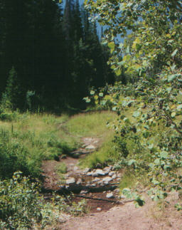
The trail features multiple creek crossings, some with large
rocks, tricky roots, and steep banks. Most are just fun little dips like this one. Photo
August 23, 1999 by Bruce Argyle |
|
 |
At the top of the canyon, Brigham Young first saw
the Salt Lake Valley. "This is the Place? Drive on. To California." he said.
(Historians have abridged his words somewhat.) Brigham
Young's group entered the valley via Emigration Canyon on July 24, 1847. Unfortunately,
they had no way of knowing that July 24 is the day of the big Pioneer Day parade.
Blundering into downtown, they were trampled to death by the Budweiser Clydesdales.
Daisies. Photo August 23, 1999 by Bruce Argyle |
| Another interesting bit of Utah history: Brigham
Young's group wasn't the first. Parley P. Pratt led an earlier group down another canyon
south of Emigration Canyon. Although it started out smooth, they got into some gnarly
technical rock at the bottom of the canyon, and Parley made a big-time Endo. To rub it in,
his companions decided to name the canyon after him. "Hey, let's all go bike in Parley's
Canyon. Ha, ha, snort." The trail ends at highway U-65 at the ridge line.
There's a historical marker here. GPS N 40° 49.687' W 111° 39.244'. The Great Western
Trail can be seen heading south from the historical marker, and north across the road.
NOTE: dogs are NOT allowed west
of the summit!
Jackie checks out the
historical marker. FYI: dogs aren't even allowed in the parking area on the
ridgeline. Obviously, this is a composite photo, totally faked. August 23, 1999 by Bruce Argyle. |

|
Heading downhill across the parking area, the Mormon
Pioneer Trail (Donner Trail) heads down towards Parley's Canyon. At the summit, you can link to the rides on the Great Western Trail -- the Lookout
Peak - Big Mountain Loop and the Bald Mountain Loop.
 |
Getting there: Take I-80 eastbound from Salt Lake. Just after Parley's
Summit, take the Jeremy Ranch exit and turn north (left) under the freeway. Turn left at
the first stop sign, then take the next right (Jeremy Ranch Drive). Continue until the
road turns sharply around to the right, where you'll see the dirt East Canyon Road
branching off to the left. At the trailhead, the East Canyon
Creek bends around banks of willows. Photo August 23, 1999 by Bruce Argyle |
*Historical footnote: These details were obtained from "A
Biker's View of Utah History," an unpublished work that will, no doubt, remain so.

|


