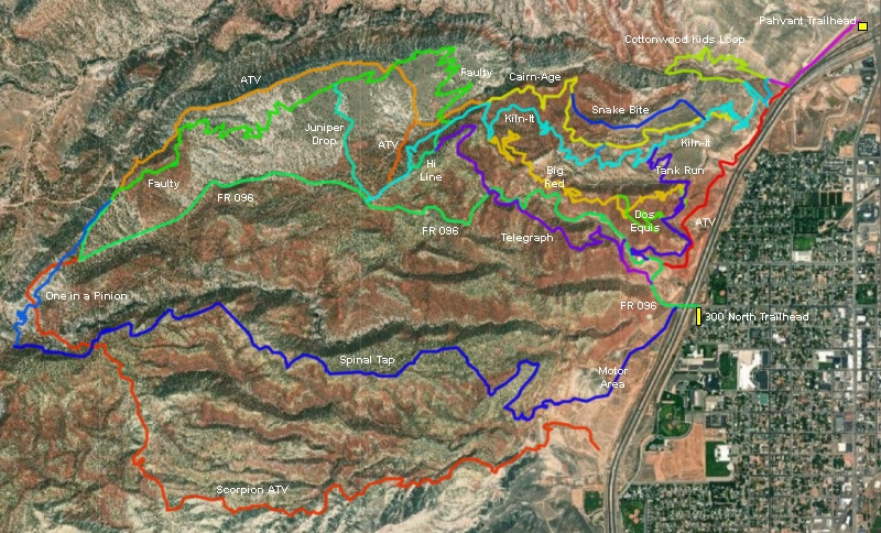
Pahvant Trail System
Kiln-It, Cairn-Age, Telegraph Area
The
Pahvant system lies on the hillside west of I-70 in Richfield. The
singletrack trails are fun and well-built, ranging from easy to expert.
For Wasatch Front riders, this system is worth the trip. The expected riding season
would be mid-May through October. This page covers the trails on the lower
mountain that can be accessed from the top of Kiln-It. The upper-area trails,
accessed from the top of Faulty, are described on upper
Pavant web page.
Bruce
climbs the twisting Kiln-It trail up through the power line corridor.
Video, photos, GPS and ride description September 13, 2019 with latest
update June 2021.
The trails are well-marked and easy to follow once you get there. It's
obvious a lot of TLC went into crafting these trails, with good alignment
choices and well-engineered bermed turns. You can do several loop rides of differing
lengths or shuttled downhill rides. A great
eight-mile starter ride is to climb Kiln-It to the ridgeline, then turn onto
Cairn-Age for the downhill.
Other trails discussed on this page include Snakebite, Big Red,
Telegraph, and Tank Run. The Cottonwood Kids
Loop is discussed in detail for parents on another page.
Rolling downhill on
Cairn-Age.
The north trailhead is at 5500 feet elevation, right off the northern
Richfield I-70 exit. Go west as you exit the interstate (away from the city) and the pavement
will end in
around 100 yards. Turn left on cindered road. Immediatelly to your left is a large gravel
parking lot, which is the official Pahvant trailhead.
Looking southwest from the parking area just off the
northern Richfield I-70 exit. On weekends, this will be your parking spot.
The trail begins as gravel road just across from the parking lot.
Local riders drive down the small gravel road parallel to
the freeway for 1/2 mile and
park where the road splits. There's room for a
couple of cars to park here on the side of the road.
There's a right-hand arrow on a carsonite post where the
larger road splits into two smaller ATV tracks, directing the bike traffic to turn 90 degrees
right. About 50 yards uphill, the Kiln-It singletrack connector trail drops
to cross Cottonwood Creek, then meanders over to the bottom of Kiln-It at
the doubletrack. The Cottonwood Kids Loop
is a bit further uphill on the DT.
Starting uphill on Kiln-It. Unless you're doing a
shuttle, Kiln-It is your best route to the other trails in the Pahvant
system.
The main trailhead is on 300 North in Richfield, where you'll pass
under the freeway to the gravel Forest Road 096. There you can find your
way uphill on either FR096, ATV trail 70, or the Tank Run trail just
uphill from the water tank on FR096.
Climbing away from Richfield on Kiln-It. First the
white dirt and next comes the red dirt.
Quick Look!
FR 096: Gravel road
for shuttle or climbing. Cottonwood Kids: easy loop for true
beginners and kids.
Kiln-It: Two-way trail, usually used as a climbing route. Quickest access
from the north trailhead.
Tank Run: Two-way trail usually used to bring you back from the southern DH
trails (Telegraph and Spinal Tap) to Big Red or Kiln-It to climb up again.
Cairn-Age: Downhill
Snake Bite: DH alternate off Cairn-Age
Big Red: Two-way trail, usually used to climb from Tank Run to upper
Kiln-It.
Telegraph: DH trail
Hi-Line: One-way, used to connect to Telegraph
Dos Equis: Short DH from lower Big Red to Tank Run.
Faulty: Route uphill to higher trails
Two-way and Climbing Trails (lower
mountain)
Kiln-It Trail
Kiln-It is 4.1 miles
long, with a climb of 1000 vertical feet. It starts on the doubletrack along
the freeway and ends on FR096. It's two-way traffic, so you can do any
portion of the trail as an out-and-back.
Heading up Kiln-It in the lower white dirt.
Kiln-It has a
connector to the midpoint of Cairn-Age at mile 2.0, with a second fork to
the top of Cairn-Age at 3.3 miles. If you climb to the top of Kiln-It, you
can continue uphill on either FR 096 or the Faulty singletrack --
discussed on the upper Pahvant trail page.
Rolling a big berm while climbing Kiln-It.
The lower 2 miles of Kiln-It is non-technical. A strong
beginner should be able to climb this first half of the trail, perhaps
with a rest break or two.
Red dirt, then white dirt. More red dirt to come.
Lower Kiln-It and Cairn-Age can be combined for an easy
four-mile loop by taking a short connecting trail at mid-mountain. Climb Kiln-It to mile 2.0, then turn
right on the signed trail fork to the Cairn-Age connector. The connector
hits Cairn-Age after around 100 yards, where you'll turn to the right
downhill.
Bruce passes the short connector trail to mid
Cairn-Age.
Waypoints when climbing Kiln-It:
0.7 Cairn-Age joins on L (do not enter)
1.0 Cross Cairn-Age
1.4 Tank Run on L (2-way)
2.0 Connector to lower Cairn-Age R
3.0 Big Red on L (2-way)
3.2 Cairn-Age on R
3.45 Connector to lower Faulty on R
3.5 Hi Line joins on L (do not enter)
4.1 Bottom of Juniper Drop then FR096
Upper Kiln-It is significantly more difficult than the
lower half, both in climbing grade and bumpiness.
After passing the connector to the middle of Cairn-Age at
mile 2, Kiln-It gets a bit steeper and you'll hit some more-technical
stretches of rock. The 1.3 miles of Kiln-It between the Cairn-Age
connector and the top of Cairn-Age would rate upper-intermediate in
difficulty.
Threading through the rocks on upper Kiln-It.
For a moderate XC ride, just climb Kiln-It to the top then
descend via Cairn-Age for 9.1 miles with around 1050 feet of climbing.
For an expert-level ride, continue uphill from Kiln-It on Faulty then
take One-in-a-Pinion and Spinal Tap to the bottom (see upper Pahvant trail page).
Drone view as Bruce crosses from Kiln-It over to
Cairn-Age, with Richfield in the background.
Tank Run
Tank Run is a traversing trail that gently climbs 150 feet over 1.5
miles. Its primary purpose is as a return trail from Telegraph, or an
access trail to Big Red or Kiln-It when starting from the main trailhead at FR096. The lower end
of Tank Run is on FR096 at mile 0.6 from the 300 North trailhead.
Note the trail between cliff and tank. That's a
shortcut to the top of Tank Run.
As you climb FR 096, you'll note a trail skirting the water tank on the
uphill side. That's not actually Tank Run, but it will take you there. The
official entry to Tank Run is around the next bend in the road. It's
well-marked. It's oriented to receive traffic coming down FR 096 from the
bottom of Telegraph, which is just uphill.
Official start of Tank Run, looking east toward the
valley.
Tank Run climbs around the hillside, with frequent views
over the valley. You'll pass a couple of descending trails that join
(unmarked as of June 2021). Just stay on the main trail. If you don't see
a trail sign, you're not there yet.
Climbing up and
around the hill. Tank Run is fairly smooth, and climbing grades are
usually gentle. If you're looking at something steep, it's not the right
trail -- it's a DH trail connecting in.
Tank Run is a two-way trail. The highly banked turns function well as
climbing turns or as a swooping roller-coaster downhill.
Looking in the downhill direction toward Richfield.
It's a beautiful S-turn.
Tank Run has some gentle descents as it gains 100 vertical
feet over 0.9 miles to Big Red. The trail fork is plainly marked, and will be on your uphill left.
Big
Red is on the left here, as seen coming from FR 096. There's a second
entry to Big Red just past the tree for downhill riders. Keep right if
you're headed for Kiln-It.
If you continue beyond the entry to Big Red, you'll get into a white-clay
zone with some rough embedded rock, plus a bit more of the red dirt. The
goal, for most riders, is to have an easier climb up Kiln-It.
You'll reach Kiln-It at mile 1.5 from FR096. Tank Run
splits to connect smoothly for both uphill and downhill riders.
Heading toward Kiln-It.
Big Red
Big Red is a two-way trail that extends from Tank Run on the bottom end
to upper Kiln-It. It's solid intermediate as a climbing route and
easier-intermediate as a descender. It's 2.4 miles in length with 500 feet
of elevation change.
Entry to Big Red, as seen when
descending (going southbound) on Tank Run.
As a climbing route, Big Red is reached via Tank Run. Climb from FR 096
(0.9 miles) or traverse over from Kiln-It (0.6 miles).
As a descender, you'll find Big Red around a mile down Kiln-It.
Big Red winds back and forth, with frequent views of
both the valley and the mountains.
Big Red is a somewhat harder climb than Kiln-It, both in
terms of grade and tech. It's more of the fun stuff you came here for!
As you climb, the short DH trail Dos Equis crosses Big Red at mile 0.6
from the bottom. The entry to Dos Equis is at 0.7 -- otherwise there are
no trail forks until you join Kiln-It.
Typical trail on Big Red, smooth banked turns, and a
bit of rock to navigate between turns.
When combined with the first portion of Tank Run, Big Red is
often used as a climbing route uphill from the
Spinal Tap trail (see upper Pahvant page),
Fun spot on Big Red. Three bridges span boulders.
If you choose to descend Big Red, you'll find it at mile 1.1 from the
top of Kiln-It. If you're doing a loop ride up Kiln-It and down Big Red,
you'll reach the top of Big Red at mile 3.0 of Kiln-It.
Winding through a boulder field.
The top of Big Red is at 6800 feet elevation, where it joins
Kiln-It at a hairpin turn.
Big Red joins Kiln-It.
Downhill Trails (lower mountain)
Down from the top of Kiln-It...
To shuttle the ride, leave one car at the bottom. Now go
back under the freeway and drive into Richfield on Main Street. Turn right
on 300 North. Pass the ATV parking lot and go under I-70. Now stay on the
broad gravel/dirt road for 2.2 miles. Watch for the small trail sign on
your right. Find a spot for your car and begin pedaling north on Kiln-It.
You will begin your ride on Kiln-It, but you can hit Hi Line (with its
connection to Telegraph), Cairn-Age (with option of Snake Bite), Big Red,
or Tank Run on your way down.
Heading downhill into the trail fork between Kiln-It
and Hi Line shortly after leaving FR096.
Hi Line Trail
When heading downhill from FR096, your first trail option is at mile 0.3. Left on singletrack is Kiln-It. Right continues ATV track for
100 feet, then you'll drop to the right on singletrack Hi Line. This trail
can be short techy alternate when descending Kiln-It, or it's your route
over to the Telegraph DH trail.
Hi Line has
two expert-level rock drops in the middle of easier cruising. The first drop
is a bit more dangerous, and intermediates may want to walk this one. Hi
Line rejoins Kiln-It after 0.3 miles.
Looking down a rock drop on Hi Line, with an initial
3-foot vertical down to the bumpy ramp.
Just over 0.1 mile down Hi Line, the Telegraph trail forks
away on the right. This is an expert-level downhill-only trail. See the
description below.
If
you elect to take Kiln-It all the way to the bottom, it will be 4.1 miles.
This is a popular shuttle option for early-intermediates and experienced beginners.
View north from the upper Kiln-It about 1/2 mile from
FR096 after Hi Line rejoins.
Cairn-Age Trail
At mile 0.9 from the top of Kiln-It, Cairn-Age forks away on
your left. Cairn-Age has some expert sections that can be managed by
confident upper-intermediates. It's 1.9 miles down Cairn-Age before it
rejoins Kiln-It.
A paver-stone highway on the ridgeline heading away
from Kiln-It.
The first half mile of Cairn-Age is the most technical.
Skilled intermediate riders can manage this upper portion of the trail
with a few walk-overs. This downhill is a lot of fun.
After the Snake Bite fork, Cairn-Age is a bit more tame. But watch out.
Between the swooping turns are many rock-drops. Most of them have ride-arounds.
Some drops you'll simply have to hit. Intermediates, keep up enough speed
that you don't drop your nose over a rock and endo!
Heading into a fun and scenic ridgeline section of
Cairn-Age.
Cairn-Age ends on Kiln-It. The trail fork aims you downhill,
but you can whip the bike around for another trip up the mountain on
Kiln-It.
Or you can coast 0.6 miles down Kiln-It to the
bottom.
Hitting the banked turn just before Cairn-Age
ends on Kiln-It.
Snake Bite
Snake Bite is a detour off Cairn-Age, 0.7 miles downhill
from the top. Like Cairn-Age, Snake Bite is one-way downhill. It starts as a
long straight rock-fest. Keep your butt off the seat and work the bike
intelligently, or you will -- surprise! -- flatten your tire with a
snakebite.
Handlebar view looking down Snake Bite. Lots of ledges
and roll-overs.
After getting through the top rock 'n bang 'n jump section
of Snake Bite, the trail settles into a blazing fast downhill dirt ribbon.
Snake Bite rejoins Cairn-Age after 0.8 miles. Keep straight
and continue downhill on Cairn-Age. Your first chance to turn around and
head back uphill will come at the end of Cairn-Age.
Drone shot as Bruce flies down lower Snake Bite.
Dos Equis
Dos Equis is a very short DH trail that drops from the lower part of
Big Red to Tank Run. It's 0.6 miles long with only 100 vertical feet of
elevation drop.
Entry to Dos Equis as seen when descending Big Red.
The trail was just finished when I rode, so it may look a bit different
for you.
Dos Equis is rated expert because of multiple drops and steep spots. There's
a bvit of ridgeline cruising in between.
Heading along the first ridgeline before dropping down
toward the Big Red crossing.
When descending Big Red, Dos Equis forks away from Big Red
at mile 1.6 after leaving Kiln-It.
Dos Equis crosses Big Red again in just 0.1 miles. Watch out for riders
here, because the crossing comes just 30 feet after you take a rock drop.
Looking uphill from Big Red at the rock drop. Watch
for riders here! Not a lot of room to apply brakes if you weren't paying
attention!
Dos Equis ends as it drops onto Tank Run, with a trail split
that puts you into the correct direction as you approach Tank Run..
Note that there's a short downhill trail lower down on Big Red. This
trail also crosses Tank Run but then joins it from below. It's only 1/10th
mile long and I mention it only because you might confuse this (unmarked
as of June 2021) trail with Dos Equis.
Fresh tire tracks on brand new trail as we roll
eastbound toward the final plunge.
Telegraph
Telegraph is a one-way downhill trail, 2.1 miles long with an elevation
loss of 850 feet. It begins in the middle of Hi Line just off the top of
Kiln-It and ends on FR096 just 0.2 miles west of the freeway. This trail
is advanced in tech requirement.
Entry to Telegraph from Hi Line.
To descend Telegraph, get onto upper Kiln-It and turn onto Hi Line.
Then 0.1 miles later fork right. At first, it will be simple cruising
through the junipers with a gradual climb.
Crossing the ridge. There's a bit of dusty sand here
that can bog you down as you climb across. Aim for the rock slabs.
After crossing a ridge, Telegraph begins descending. It
motors right along. There are ledge drops that come fast and furiously.
Just getting started, and here are the first two
drops.
Most, but not all of the drops will have ride-arounds. Some
you just have to ride over -- or look both ways to be sure no one sees
you, then sneak down to the bottom.
Timid riders may want to do a scouting run first. But
there's only one drop (lower down) where blindly dropping could easily get
you hurt. There's an off-camber weird 2nd ledge below the drop that can
send you off the trail.
There will be frequent views of the Richfield Valley
whenever the trail breaks out into the open.
It's not all techy. There are long stretches where
you can just let the bike fly and enjoy riding.
A couple of fun spots. Here there are two
lines. but each one
has two two-foot drops. The right line gives you more time.
This rock face is probably the biggest
tech feature on Telegraph,
but it's not the trickiest. Just aim the bike straight down and go.
As you approach the bottom of Telegraph, the trail splits. If you hook to the left, you'll descend to FR096 above the water tank,
where a short run down the gravel road delivers you right to Tank Run, if
you're on your way to Big Red or Kiln-It for another go.
At the trail fork near the bottom. A hard left turn
takes you to the road just above the entry to Tank Run.
If you continue straight down the ridgeline, you'll hit FR096 near the freeway. The main trailhead is downhill right.
If you wanted more riding, you'll need to turn left uphill and crank back
up.
This is the final drop to the road if you go straight
down. As you can see, most riders have voted to drop off the fin and go
around.
Loop ride with Kiln-It, Cairn-Age and Snake Bite...
If the above video does not appear on your
browser/device, you can watch it on YouTube by clicking
here.
Getting there:
Pahvant (northern access) parking: At the north Richfield exit from I-70, turn north (toward the mountains).
As the pavement ends, turn left onto a gravel road, then left again into the
Pahvant parking area. Start the ride either on the small gravel road heading southwest
parallel to the freeway, or on the singletrack near the trail sign (the
two routes will rejoin after 0.3 miles). After 1/2 mile, follow the trail sign by turning
right on a smaller gravel ATV track. (Note there's room for a couple of
cars here where the doubletrack splits.) Veer left onto singletrack after
0.1 mile to head for Kiln-It, or continue uphill on the doubletrack for
the Cottonwood Kids Loop.
300 North (FR 096) parking: From Richfield's Main Street, turn west on 300
North. As you approach the freeway, turn left into the ATV parking lot.
Pedal under I-70 to head uphill on FR096 to reach the top of Kiln-It.
Shuttle: Top of Kiln-It: Drive uphill on FR 096 2.2 miles and
find DT on your right with a carsonite trail marker. Top of Faulty:
continue to mile 4.1 of FR096 and find marked ATV track on the right, with
singletrack across the road on the left.
Bathrooms and water: none at trailheads (businesses nearby)