 |
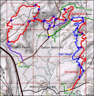
Sovereign Upper Loop
(Cedar Mountain)
The Cedar Mountain loop is formed from a continuation of the Sovereign
Singletrack plus the Cedar Mountain singletrack. The loop can be ridden as
a ride in itself, although I wouldn't suggest you skip any of Moab's
classics in order to ride it.
View southbound on the Cedar Mountain
Trail. This smooth and firm singletrack is the exception. Photos and
write-up by Bruce, May 1, 2009.
|
| The main role of the Cedar Mountain loop (as I see it) is as an add-on to the
Sovereign and Salt Wash system for very strong and experienced riders. If
you've done the Moab classics too many times, crank out some miles on this
loop.
Upper Sovereign offers a few optional
detours. Terry's Tunnel is an advanced technical route that includes a
rock wash. |

|
|

|
The loop itself is about 6 miles, but getting there will
make your shortest ride 8.5 miles with total climbing around 600 vertical.
This ride starts near the highway on Dalton Wells road, climbs up the loop
and descends. I also describe a 10-mile option that includes the upper
Sovereign, starting at the inner Dalton Wells trailhead.
On upper Sovereign, we're approaching
the main trail from a side
trip on the more technical detour. The green slopes are shales
of the Morrison Formation, famous for dinosaurs. The loose rock is
Buckhorn Conglomerate that's fallen from the cap of the mesa. |
|
Strong riders can start from Sovereign's Willow Springs trailhead, ride
Sovereign to the Cedar Mountain loop and return via Salt Wash. This ride
is 20.5 miles with 2000 feet total climbing, and it's a tough ride. (See
the Salt Wash page for riding details below
Dalton Wells road.)
Heading south on another limb of an
optional more-technical
detour route off upper Sovereign. The riding is fun, but not
for everyone. Intermediates will want to stay on the main trail. |

|
 |
For details on some other riding options, see the Sovereign
Singletrack trail page. Arriving at the base of the loop from the
upper Sovereign trail, you'll face a stiff climb of over 300 vertical in
1/2 mile. The track is narrow, with occasional loose spots and rough
angular rocks. If you don't enjoy challenges, you won't like this.
We've arrived near the top of the
climb to the loop from upper Sovereign, and are looking back down at the
trail. The trail's sweet spot is very narrow, so you need both strong legs
and excellent bike control. |
| Once you arrive at the T intersection at the top of the
loop, you need to pick a riding direction. I suggest you go
counterclockwise. You'll quickly get to an area with great views, then
smooth singletrack, followed by a fun descent down a long arroyo.
View west as we head slightly downhill
riding clockwise. The trail is rough here, so even though it's slightly
downhill overall, it seems like a lot of work. That's why I recommend a
counterclockwise ride, putting this stretch on the uphill. |

|
 |
The trail surface here is very unlike the lower portion of
Sovereign. Yes, there's some open rock (see photo) on the west end that
will remind you of the fun stuff to the south. But most of the trail here
features rock with sharp edges, plus loose angular babyheads. It was rough
enough to separate the batteries in my GPS from the spring contacts
(turning the unit off) three times.
Seriously, if you're an intermediate rider who likes cruising, you'll
hate this trail. The
rough Buckhorn Conglomerate at the top of the mesa breaks into tire-hating
chunks! But if you enjoy challenges and relish conquering a trail
that throws nasty stuff at your tires, just follow my tire tracks.
At the loop's lowest spot on the west,
the trail often follows wash-bottoms. The riding surface here is loose and
granular, with occasional open rock. |
| The highest point of the ride is Cedar Mountain. There are
views in all directions. To the west, you can see the Monitor and Merrimac
buttes. The La Sal mountains dominate the southern view, with rocks of
Arches National Parking forming the skyline to the east. The crags of
Cedar Mountain have a stark beauty. At the top of Cedar Mountain, we ride
along these fissures. Pieces of the mountain are breaking away, ready to
fall from the cliff into the valley below. Here you'll get to appreciate
the rough nature of the Buckhorn Conglomerate. |

|
 |
If you're riding counterclockwise, you'll find great fun
between Cedar Mountain and the loop's western end. The Cedar Mountain
trail descends on smooth twisting singletrack, then enters Ann's Arroyo
for a mile of downhill in a small canyon.
Handlebar view in Ann's Arroyo. |
| The short riding option I describe below uses the Bushy
Basin singletrack to climb to the (lower) west end of the loop. This is a
quick ride you can knock out in about 90 minutes.
The second option is a longer "tour" of upper Sovereign. If
you're riding into the area from lower Sovereign or Salt Wash, you can
pick up this route at mile 1.2 where Sovereign crosses the ATV route after
descending from the bluff.
View downhill on the Bushy Basin
trail. |

|
Quick loop via Brushy Basin:
0.0 East on Dalton Wells from parking right off 191
N38 42.720 W109 42.108
0.3 Fork L on DT, N38 42.821 W109 41.858
1.0 Go to north end of basin, take ST
N38 43.187 W109 42.380
1.5 At loop, fork R, N38 43.420 W109 42.457
3.0 Keep straight (L=to DT)
N38 44.091 W109 41.602 |
3.4 Keep L onto Cedar Mountain trail
N38 44.180 W109 41.358
4.0 Cross DT, N38 44.478 W109 41.200
4.4 Veer L along wash, cross DT
N38 44.612 W109 41.350
Enter arroyo
5.7 Cross DT, N38 44.120 W109 42.361
7.0 Back at Brushy Basin Trail, go R
8.5 Back at parking |
Upper Sovereign plus Cedar Mountain loop
(tougher):
Drive or bike to trailhead at mile 1.7 on Dalton Wells Rd
0.0 R fork (ATV route) eastbound
N38 43.586 W109 40.782
0.2 Keep straight, N38 43.66 W109 40.54
1.2 Hard L to Sovereign ST in wash
N38 44.152 W109 39.823
1.7 ST reaches slickrock, keep L
1.9 ST exits slickrock on L
2.1 Stiff climb
2.3 Top of hill, fork L (gets sandy)
N38 44.485 W109 40.124
(Alt R, then R on road to
bypass sand)
2.8 Fork L, N38 44.127 W109 40.073
(straight = alternate, R at
road to trail at 3.4)
3.3 L on road, N38 44.178 W109 40.470
3.4 R up smaller road, N38 44.145 W109 40.499
3.6 L on ST and drop into wash
N38 44.254 W109 40.577
(straight = easier alternate,
rejoins 4.5)
4.2 L and out of wash, N38 43.936 W109 40.744
4.5 Fork L, N38 44.119 W109 40.956 |
4.6 Fork R uphill into wash
N38 44.084 W109 41.019
5.2 Fork L on Cedar Mountain
N38 44.180 W109 41.358
5.8 Cross DT, N38 44.478 W109 41.200
6.2 Veer L along wash, cross DT
N38 44.612 W109 41.350
Enter arroyo
6.5 Cross DT, N38 44.120 W109 42.361
6.8 At Brushy Basin Trail, keep L
Option: R to Dalton Wells Rd
8.3 Keep straight (L=to DT)
N38 44.091 W109 41.602
8.7 Fork R off loop, begin descent
N38 44.180 W109 41.358
9.3 Bottom of wash, veer L
N38 44.084 W109 41.019
9.4 R onto ST on rock, N38 43.936 W109 40.744
9.7 Fork R downhill in wash N38 43.936 W109 40.744
9.9 Exit wash, R on road, N38 43.846 W109 40.794
10.2 At parking |
 |
From the north, Dalton Wells road is 17 miles
south of I-70, on your left. Willow Springs Road is exactly 1 mile further
south, also on the left. Coming north from Moab, Willow Springs Road will
be on your right, 1.8 miles past the junction with Highway 313 (Canyonlands
and Dead Horse Point).
Getting there, Willow Springs Road Trailhead:
On US-191 north of Moab, turn east on dirt Willow Springs Road. Keep L at
fork at mile 1.3. At mile 2.0, park in the rock-outlined area on your left N 38° 41.876' W 109° 39.868', just before a
natural gas pump building on the R. Start the ride by continuing down
Willow Springs Rd. For this ride, you'll need to finish Salt Wash or
Sovereign northbound before connecting to the upper loop -- big ride!
Getting there, Brushy Basin at Dalton Wells Road: On US-191
north of Moab, turn east on dirt Dalton Wells Road. Keep straight to the
trees and park just off the dirt road. Start riding the same direction you
were driving. Cross the sandy wash. At mile 0.3, fork L on DT. The DT
becomes ST just uphill from the stock pond. |
|
Getting there, Dalton Wells Upper Trailhead: On US-191
north of Moab, turn east on dirt Dalton Wells Road. As the cindered path
turns R, go straight onto the dirt road. If the gate at mile 0.2 is
closed, pass through and shut it. Cross the broad sandy wash. At mile 1.7, park at the fork in the road N 38°
43.584' W 109° 40.783'. The R fork takes you to the various upper
Sovereign riding options. The L fork takes you further on ATV track into
the valley where you can connect to the southern 6 miles of trail. |

|


