The Strawberry Narrows Trail is a 12-mile singletrack that skirts the
southern edge of the narrow band of water joining Strawberry Reservoir to
Soldier Creek Reservoir. It begins at the Aspen Grove Marina on the east
end of Soldier Creek and ends at the Renegade Point marina at the
southwest corner of Strawberry. Average altitude is 7500 feet.
View west in the middle of the
Strawberry Narrows, 4.7 miles into the ride at altitude 7700 feet. Photos
and trail description by Bruce, June 25,
2009.
The trail is usually done as an out-and-back from the
eastern end. Some riders like a point-to-point with
shuttle vehicle or "significant other" pickup.
The whole trail as an out-and-back is 24 miles with around 2200 feet of
climbing. But
shorter rides are possible, and most riders will select one of these. For
less-strong riders, four miles to the overlook and back is satisfying. For
strong riders, 8 miles to Poison Ridge and back.
View north over Soldier Creek as we
ride westbound at the trail's eastern end.
You'll climb from the lake surface to 400 feet
above (a couple of times), plus rolling up-and-down riding. The singletrack is narrow with encroaching berry bushes and baby aspen. The trail is intermediate technical, nothing
tricky. There's one half-mile section of steep side-slope.
A boat heads west in the narrows ahead
of us as the trail rolls through the fir trees on the mountain side.
Few riders will want to do the entire trail. The western end
is 4 miles of sage brush -- and swamp, depending on the time of year. If
you happen to be camped at the west end or are doing a point-to-point, fine, ride it. But if you're
driving to Strawberry specifically to enjoy this trail, I suggest you start
at the eastern (Soldier Creek) end and turn around at Poison Ridge for a
16 mile out-and-back with 1600 vertical.
View down the trail as we head through
an aspen grove.
The eastern 8 miles of the trail is absolutely beautiful.
You'll roll up and down through aspen and fir forest, with frequent
breakouts into small meadows overlooking the lake. The trail twists into
side canyons and crosses a couple of small creeks.
There are a few very short grunt climbs, but most of the riding is
gentle climbing and descending. Views are terrific.
In the narrows, the terrain varies
from grass meadow to sage to aspen to shady fir forest.
The sun-exposed areas are thick with wildflowers. Even the
sagebrush flats had plenty of lupine and sticky geranium. In areas of
mixed aspen and fir, wild raspberry bushes and snowberry flank the trail.
Near a bridge over a creek, spawning
trout jockey for position
in a pool below a small waterfall. This photo was from 2009. On the exact
same date in 2018, this creek was bone dry.
Navigation from the eastern end is very straight-forward,
once you find the trail. There are plenty of trail markers, including mile
markers to let you know how far you've come.
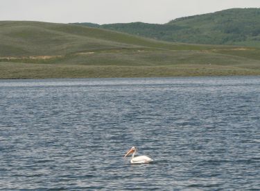
A pelican cruises near
shore as the trail drops through the
sage brush to the shoreline on Strawberry.
For an adventure, consider bicycle camping. There are primitive (pack
in, pack out) camping spots near both entrances to the narrows.
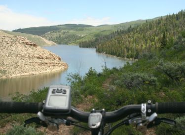
Handlebar view as the trail skirts a
side canyon. The creek feeding this bay was thick with two-foot spawning
trout. (Note: it's illegal to fish for, or mess with the spawning fish in
the creeks. Unless you're a bear.)
In 2009, I found the western end of the trail to be seriously overgrown with
sage and grass -- about as close to "not trail" as a trail can
get. But it should improve in later summer as more people use the trail.
About two miles from the west end, the trail disappeared into water three
times. In other areas, the trail was merely a linear "thin spot"
in the brush, completely grown over by grass. Many eastbound riders will
skip the official trailhead and drop in from Big Springs (see directions
below).
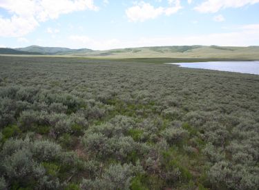
This is the western end. Miles of sage
flat. Do it, if you want to say you've ridden the whole thing.
Bottom Line:
This is a must-ride trail. Beautiful scenery, fun riding. For
early-intermediates, the ride to the overlook is fairly plush, 8 miles
round trip. Stronger riders will like the out-and-back to Poison Ridge.
Cranking up Poison Ridge. Once you get to the top,
it's a good spot to say "I'm here" and turn around for the
out-and-back.
Out-and-back from Aspen
Grove to Poison Ridge
If the above video does not appear on your
browser/device, you can watch it on YouTube by clicking
here.
Strawberry Narrows, east to west, with
loop at west end:
0.0 Find ST trail at NE corner of Aspen Grove Marina parking
N40 07.682 W111 02.209
(Parking here requires fee. Go
0.3 miles up road for rough parking.)
0.3 Reach DT, continue SW direction on DT
N40 07.851 W111 02.316
0.8 Sharp R on ST (if you reach fence, go back!)
N40 07.554 W111 02.706
1.2 Badger Point, trail turns L
1.7 Primitive camping area on R, N40 07.680 W111 03.059
2.5 Entering narrows area
4.8 Viewpoint west over narrows, N40 07.469 W111 04.837
6.2 Fork R, small bridge over stream, N40 07.159 W111 05.738
7.3 Primitive camping area on R, N40 07.624 W111 06.363
8.0 Poison Ridge, view of Strawberry, consider turnaround
N40 07.813 W111 06.995
9.5 Keep L at fork, continue on ST, N40 06.726 W111 07.803
9.9 Cross creek (may need to
detour upstream)
N40 06.813 W111 08.146
10.0 More water, go around, N40 06.898 W111 08.169
11.4 Cross trail (L = up to road TH), N40 07.032 W111 08.956
12.0 Marina, go L up road, N40 07.460 W111 09.188
12.3 Turn L (gravel road), N40 07.292 W111 09.317
12.8 Pass pullout for alternate TH, N40 06.991 W111 08.967
14.1 Fork L on narrower road, N40 05.905 W111 09.017
14.9 Enter Big Spring area, ignore first couple of spurs
15.1 Fork L as main road turns from NE to east,
before it turns SE again.
DT goes straight north.
N40 05.635 W111 08.230
15.2 Wood fence, go through
16.4 Barrier fence, go around, N40 06.653 W111 07.875
Find ST 100 feet
downhill, turn R = original route
N40 06.726 W111 07.803
26.0 Back at Aspen Grove Marina
Getting there, east trailhead (recommended) - Aspen
Grove: On
US 40, go eastbound up Daniel's Canyon and cross the summit. Continue on
US 40 past Strawberry Reservoir. Pass the Soldier Creek campground, then
1/2 mile later turn right toward Soldier Creek Dam (road fork is N40 10.960 W111
01.690). After 3.3 miles, keep R at the fork and continue toward the dam
and marina. At 4 miles from US 40, turn R and go across the dam. At 5.2
miles, you reach the intersection for the Aspen Grove campground (left)
and the marina (right). Park at the marina if you've paid the fee. Find
the ST trail at the northwest corner of the parking area N40 07.682 W111 02.209.
(For free parking but a shorter ride, continue another 0.3 miles on the
paved road. Just after the road turns to the left, exit on dirt
doubletrack N40 07.851 W111 02.316. You can park here and ride SE on the
DT, or drive the DT 1/2 mile to a wide spot in the DT (do not go through
the gate in the fence) N40 07.554 W111 02.706. Backtrack about 50 feet to
find the ST heading north.)
Yes, this is the trail at the western
end. Later in the summer, the water will retreat.
Getting there, west trailhead - Renegade Point: On US 40, go
eastbound up Daniel's Canyon and cross the summit. 4.7 miles after the
summit, turn R on the main Strawberry road. Continue south toward Indian
Creek at the far southeast corner of the reservoir. Turn right at the
marina and park there if you've paid the fee. The trail is at the
northeast corner at the top of the boat ramp N40 07.460 W111 09.188. For
free parking, continue straight past the marina turnoff and go 0.7 miles
on gravel road. Park at the pullout on your left N40 06.991 W111 08.967.
Drop 0.1 mile down the trail and watch for the Narrows trail as it crosses
at N40 07.032 W111 08.956. Turn R.
We're heading back now, eastbound.
This is the view from Poison Ridge as we again enter the narrows.
Big Springs (alternate) trailhead: Continue past the Renegade
Point marina as above, then fork left on a smaller dirt road after 1.9 miles
at N40 05.905 W111 09.017. Go exactly 1.0 miles up the dirt road, ignoring
a couple of spurs. At a spot where the road turns right (from northeast to
southeast, fork left at N40 05.635 W111 08.230. Go about 1/4 mile. Find a spot to park near the log fence and continue north.
Just for fun. This is not a rock. It's
a giant member of the fungus family growing on the side of the trail.
Bathrooms and water are available at the marinas at each
end of the trail. Note that these are fee areas -- but at the Aspen Grove
marina, you don't need to purchase a pass while you shop at the general
store so you can hit the bathroom after buying your granola bar.