Located in Red Canyon just outside Bryce Canyon National Park, Thunder Mountain combines technical
riding with amazing views. The trail is 7.9 miles long and is both
technically and physically difficult. It's one of Utah's classic must-ride
trails.
The Thunder Mountain trail climbs past hoodoos of
limestone. Original trail review and photos by Bruce on July 17, 2001.
Latest update 2021.
The top elevation on the Thunder Mountain trail is 8200
feet, so "spring riding time" comes late here. The expected
riding season will be late May through October.
The Claron Formation limestone is the same rock
that's found in beautiful Bryce Canyon National Park. The scenery is the
reason riders come here.
Before tackling Thunder Mountain,
you should be comfortable riding on loose surfaces, near steep drops, and
through tight switchbacks. That means expert riders. Strong and determined
intermediates can manage with a bit of walking.
Much of the trail is "climb a little
then drop back down a little" over and over. You'll never do so much climbing on a
"downhill trail."
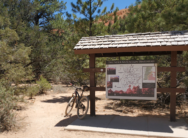
Trailheads!
The lower Thunder Mountain trailhead is on Highway 12 at 7100 feet
elevation, 3 miles from US 89. The trailhead is on the right side of the road
just as you enter Red Canyon. This is where you'll go first,
whether to leave a shuttle vehicle or to begin your ride up the paved bike
trail. (I intend to talk you out of doing the out-and-back ride. But if that's
what you're doing, the trail entry to start uphill is at the rear right
corner.)
Exit from the trail at the lower Thunder Mountain
trailhead -- or entry to the trail if you're riding uphill.
The upper trailhead is at Coyote Hollow. As you drive east on U-12, go
8 miles up Red
Canyon until the road levels out in a sagebrush area. A gravel road,
called "Fremont ATV Trail" crosses U-12 and you'll see a
bathroom and parking area to your right. The sign says "Red Canyon
Trail" -- meaning the paved trail -- but the road goes to Coyote
Hollow and the top of Thunder Mountain. Turn right but don't park here. Drive 2.1 miles to the Coyote Hollow
trailhead for your shuttle drop-off.
This is the Coyote Hollow trailhead, and the end of
the road. Don't be fooled by the big kiosk about half-way down the Fremont
ATV trail.
Riding options!
Almost everyone does this trail top-to-bottom, whether by shuttle or with a
climb up the paved Red Canyon trail. It IS possible
to ride it from the bottom out-and-back. I did that 20 years ago, and it was
brutally hard. And now, as the trail has been affected by increased horse and
bike traffic, the switchbacks in miles 1.5 to 3 are almost impossible to clean
uphill because of the combination of boulders and moon dust.
About to have some serious fun! Looks pretty easy so
far, right?
Out-and-back is a brutal proposition, because it's easy to
underestimate the beating your legs will take from the up-and-down riding. If you ride the trail as
an out-and-back, it's 15.8 miles, and you'll do over 3500 vertical. This is a
trail that, in a very real sense, is "uphill both ways."
Typical trail section for the first 4 miles. Up and
around, then back down.
So I'm going to gently suggest that, if you have two cars,
you do the shuttle thing. If not, plan on a loop ride where you enjoy the
5.4 mile cruise up the paved Red Canyon trail,
the 2.2 miles on gravel road that is the Fremont ATV trail, then 7.9 miles
of fun on Thunder Mountain. Your ride will be 14.5 miles total, with total
climbing of 2200 vertical feet. Only 900 feet of that climbing will be on
paved trail and gravel road.
View back to the east from a high spot in the trail.
Not THE high spot, just A high spot.
But here's another option. You can backtrack a bit down U-12
and take the gravel road to Casto Canyon. After
climbing Casto, hang a right turn on Fremont ATV and ride south to the
trailhead, crossing Highway 12 as you go. The miles are mid-20s with
around 300 feet more climbing than the paved bike trail. Casto is an easy
ride technically.
Hoodoos in the canyon near the end of the downhill
ride. Serious eye candy here!
About the ride!
The dirt and rock are from the Claron Formation. This soft rock originated at the bottom of a large lake that extended
from eastern Utah into the Bryce Canyon area. It was deposited about 40 million years ago, long after the
extinction of the dinosaurs. Mostly it's creamsicle orange, with some
bands of white.
Melted creamsicle terrain as we get
started on Thunder Mountain.
Riding through the forests of the Thunder Mountain Trail
will seem strange to bikers who are used to the dense brush and trees of
the high Wasatch. Here, long-leaf pines stand well-apart, with low
manzanita scrub
on exposed rocky soil, and a few cedars sneaking in between the pines.
Manzanita is a handsome spreading shrub
with round, firm light-green leaves growing on dark red branches.
The singletrack undulates up and down, back and forth. If your
legs are fresh, you may consider this a cruise. But most riders will find
this ride a satisfying bit of work. As you look at the map below,
understand that every tiny wiggle is a descent into -- and a climb out of
-- a drainage. You're never "finished" with the climbing until
the last mile.
Near the Coyote Hollow trailhead, the
trail rolls up, down, and around mounds of orange and white rocky soil.
It's rare to encounter hikers on the trail, but Thunder Mountain is used
daily by commercial horse outfitters. The typical equestrian group is 6 to 10
riders, and they'll be together in a line. You may need to backtrack a bit on
the trail to find a spot where you can safely get off to the side to let the
horses past.
The first half of the trail has few breakout views.
This is one of them, looking north.
When riding top to bottom, the first 4 miles are
intermediate trail. You'll climb a bit then descend a short distance as
the trail contours the hillside. But the general trend is to slowly gain
elevation. You'll go from 7900 feet at Coyote Hollow to 8200 at the ride's
high point.
A selfie with the hoodoos is a must-do
for this ride; in fact I think it might be legally required!
There will be several "false summits" where you
think you've crossed the top and now be going mostly downhill. Sucker!
You're about to climb again! You're only
on the downhill side when you can see the long stretches of the trail
descending into the deep canyon to your right.
Looking from a ridgeline to downhill switchbacks
ahead. Now you're really on the way downhill now!
As the trail begins dropping quickly just after mile 4.5,
there will be some rough steeps and very difficult switchback turns. The
embedded boulders are more difficult because of the deep dust in the
trail.
Steep pitch down to a difficult switchback.
But at least you're through climbing, right? Ha! The trail
just keeps finding new excuses to climb back uphill. After all, you picked
a trail that climbs 1200 vertical feet as it goes downhill!
Climbing again! But just look at these views!
Take some time to enjoy the two exposed fins where the world
falls away on both sides. This is a favorite photo and video spot!
Dominic, Matt, and Mike
thread along
the top of the ridgeline fin. Headed downhill, we'll be dropping off this
fin towards the rocks in the background via a series of sharp switchbacks
into Red Rock
Canyon. Photo September 2003.
As winter run-off, rain and erosion change the trail, you
may find it a different experience. For example, this photo spot now has a
steep rock garden instead of smooth dirt. And when the trail is firm --
instead of deep horse- and bike-churned moon dust -- it's a very different
ride!
Bruce attacks a short steep on lower Thunder
Mountain in 2003.
Another series of switchbacks is coming, this time closer
together with tighter turns. You're now dropping the steep flank of the
deep colorful canyon you've been seeing for the last couple of miles.
You're going to lose 100 vertical feet in 1/10th mile, an average 20%
down-slope!
On the final run of switchbacks.
The trail now drops to the canyon bottom. Did you take a
minute or two to enjoy the fabulous views of orange rock and hoodoos?
We're about to hit the dry creekbed and cross over.
The trail hits a trail fork at the bottom
of the canyon. Turn to the right and climb over a low rise. Yes, climb.
What made you think you were through climbing?
The trail now rockets north toward the trailhead for one mile. It's the
only section of non-interrupted downhill you get on this ride! Watch for
horses, hikers, and climbers!
Heading toward the trailhead on the final mile. A
great ride. Well-done!
Bottom Line!
Thunder Mountain is a classic, and it's one of Utah's Must Ride trails.
The scenery is awesome and it's something you'll never forget. But it's
not a cushy ride, and certainly not for inexperienced or weak riders. It's
just as hard with a shuttle as it is if you do the loop ride. You can ride it as a "scenic loop,"
as a
butt-kicking "downhill," or as a seriously insane hill climb
out-and-back.
Jackie
pauses on the ridgeline, as we head towards the top of Thunder Mountain
on a very tough out-and-back ride on July 17, 2001.
Thunder Mountain: a
video from the Good Old Days of 2003
If the above video does not appear on your
browser/device, you can watch it on YouTube by clicking
here.
Getting there:
Coyote Hollow Trailhead: Driving east on U-12, go all the way up Red
Canyon until the road levels out in a steppe area at the top (about 8
miles from US-89). Watch for a gravel road GPS N 37° 43.169' W 112°
15.322' (on both the right and left sides of the road) about 1/2 mile
after reaching the top of the hill. The road is labeled "Fremont ATV
Trail." Turn right and drive 2.1 miles to the Coyote Hollow trailhead
at GPS N 37° 42.156' W 112° 16.758'.
Thunder Mountain Trailhead: Drive east from US-89 on U-12 (about 3 miles)
until you reach the Thunder Mountain parking area on your right, just
before "Red Canyon" sign. GPS is N 37° 44.595' W 112° 19.747'.