 |
Trailside Loop and Skills Park
Trailside Park is located about a mile south of I-80 and a mile west of
US-40 near Silver Creek Junction. There's a one-mile, well-groomed
singletrack loop. But the main reason to come here is the Skills Park,
located on top of the ridge at the southern end of the loop.
View from the ridgeline toward The Canyons from the
Trailside Park Loop (TSP). Initial photos and description by Bruce
on May 23, 2006, with most recent trail update September 2022.
|
|
The park has flow trails and skills areas. The easy trails are the DH
one-way flow
trails Yabba Dabba Doo and Great Gazoo, plus the Trailside Park Loop
(TSP), which is a two-way trail. Bronto Jam is an intermediate flow trail, and the
expert DH trails are Bamm Bamm and Mr MuchRocks.
Here's a nice toy in the photo on the right. Start with the
balance beam, then the ramp. Take your choice of teeter-totter (route
furthest from the camera), or the gnarly stairway.
|

|
 |
The DH flow trails are reached via the Trailside Return
trail and Hailles Return. It's a pretty quick trip up to the top. See the
map below for the trail layout. The
DH trails vary between 0.6 miles (Bronto Jam) and 0.4 miles (Bamm Bamm) in
length, with around 100 feet of elevation loss.
Or let's start a little
easier. Go to the low-altitude, minimum-tip teeter totter nearby, seen in
this photo. |
|
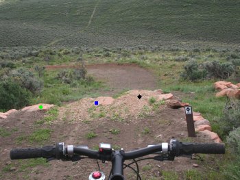
Want to practice jumping? Trailside park is famous for its jumps on
Bamm Bamm and Mr MuchRocks.
Drop over the edge and pick your
line. The artificial ledge features a low route (green circle) with a ramp
rock so you can't mess up too badly.
|
|
 |
The park has evolved over the years, and now features a
large full-services trailhead. You can also connect through to the Round
Valley trail system from the park, although Round Valley has its own
trailhead just down the road from Trailside Park. Many
riders connect a big ride in Round Valley to laps in the bike park via a
connector trail from Happy Gilmor, the northernmost trail of the Round
Valley system.
Then there's the intermediate ledge
(blue square) in the middle. At the far right side of the jump, there's the black diamond (bike
shown for size comparison). In the photo above, note the bermed runout at the bottom. |
|
There are several balance stunts. On the left, this is a
fairly tough one, with a bit of elevation to make it scarier. Note the
log-pile on the trail above the balance strip. In the photo at right, you see the end of a
ground-level beam on the left side of the photo and a broader boardwalk
with a "slippery log" and a nice low wheelie-drop edge.
|
 |
There are a couple of practice rockpiles for control and
balance. Rockpiles to practice attack and bike
control, photographed before riders were using the bike park regularly. |
| Several logs and logpiles are there for your riding
pleasure, so you can work on your crank-clearing
technique.
A couple of log-hopping challenges.
|

|
 |
A couple of bermed turns at the downhill end of the Skills
Park take you into these dirt jumps. Launch off the high side, touch down
on the downside. Each one gets a little broader. At the bottom, a bermed
turn rockets you back uphill.
The park has bathrooms, picnic area, and a big playground. The whole
family can have fun here. The singletrack loop is very wide and smooth,
perfect for pulling a trailer full of kid. Warm up on the one-mile loop,
then go nuts on the fun stuff while the non-bikers hit the playground.
Some table jumps. This photo was taken when I first
explored Trailside Park in its infancy. Nowadays it's not a good idea to
ride with dogs here. |
| Getting there: From Salt Lake City, go east on
I-80 over Parley's Summit. Skip the Park City exit, and exit at the US-40
(Heber, Silver Creek) exit a couple of miles later. Turn right on US-40.
1/2 mile later, exit at Silver Summit and turn right on Silver Summit
Parkway. A mile later, you'll come to a stop sign. Here the main road
turns right, and you'll see a parking area straight ahead. Look left, and
you'll see a dirt trail going uphill alongside a paved trail. (The dirt
trail's the one you want.) Go through the stop sign and find a spot to
park, then backtrack to the dirt trail and start uphill. |

|

|


