 |
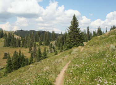
Wasatch Crest to Midmountain Loop
from Deer Valley
This is a epic ride of 35 miles. You'll do about 3500 vertical feet of
climbing. It's for very conditioned riders only. You'll start at 8100 feet
elevation, climb to over 10,000 feet, and descend to around 7800 at the
ride's lowest point.
Photo courtesy of Rodney Strader,
taken from the Wasatch Crest in early October 2010.
|
| The ride starts from Silver Lake Lodge (the upper lodge) at
Deer Valley. If the thought of driving uphill bothers you, climb Deer
Crest from the lower (Snow Park) lodge.
From the lift area in front of Silver Lake Lodge, turn to your right
and descend a little to go under the skier underpass. Immediately as you
pass under, veer to the left onto singletrack trail. You're on the
Midmountain.
Beginning the climb up Team Big Bear
in September 2011.
|

|
 |
At mile 1.4, turn left uphill onto Team Big Bear. The trail
will zigzag up the slope, through deep fir forest and across ski slopes.
As you near the top, the forest changes to aspen and brush. As the trail
skirts a gravel road, keep left on the singletrack.
On the upper slopes of Team Big Bear,
the grade gets milder as you follow the edge of the hill. |
| After traversing around the edge of the mountain, Team Big
Bear ends at the beginning of the Flagstaff Loop. Take the right fork.
After 1/3 mile, fork right onto doubletrack and pedal west and slightly
uphill. You're on the Road to Ruby.
The Flagstaff Trail. Watch for the
signs for Road to Ruby, which is your route to Guardsman.
|

|
 |
Keep left when the doubletrack to the Ruby Lift itself forks
off on your right. When you reach the paved Guardsman Road (SR 224), go
across to parking, and find the doubletrack heading west at the end of the
parking area.
We've crossed Guardsman Road, and
we're looking back east at the parking area we crossed to get on the
DT. |
| Head west and uphill on the doubletrack, passing the entry
to the upper TG trail after 0.1 mile. Keep heading west, ignoring any
paths that take you downhill to the Guardsman Road. There will be a couple
of stiff ridgeline climbs. For most of us, there will be a short
hike-a-bike of about 200 feet on one of those climbs.
View south from the doubletrack,
climbing westbound.
|

|
 |
When you approach a fork in the doubletrack, watch carefully
for narrow singletrack on your right. The DT will go left of the mountain
straight ahead (and send a branch down to the road), and the ST will to to
the right.
The trail follows the ridgeline to the
north of the Guardsman Road. |
| The singletrack heads straight west on a steep side-slope
for about 0.1 mile. When you reach gravel road, turn to the left uphill.
(Note: if you need to bail, this DT takes you downhill to TG and on to
Midmountain near Empire Canyon Lodge.)
At the ridgeline, go past the first DT coming in from the left (the
returning DT from the other side of the mountain). Keep to the left at the
fork -- don't take the steep uphill DT. Aim straight ahead and head gently
downhill to join the Guardsman Road.
Singletrack entering the forest as we
leave the ridgeline doubletrack.
|

|
 |
The Guardsman Road is well-traveled. So you'll be mooshing
in loose dirt under your tires and sucking it into your lungs as the
monster trucks go by. But it's only for about a mile.
When you reach the parking area at Guardsman Pass, turn right onto an
uphill doubletrack. This is the beginning of Scott's Bypass. Drop off the
DT onto singletrack after about 0.2 miles.
Looking down Big Cottonwood as we head
from Guardsman Road toward Scott's Bypass. |
| Scott's Bypass heads along the ridge for about 1/2 mile,
then drops through a few turns through aspen forest. Then it heads
downhill to Scott's Pass (where the doubletrack from the Guardsman Road in
Big Cottonwood meets the trail from Shadow Lake, and where you'll start
the Puke Hill climb).
Scott's Bypass Trail, northbound.
|
|
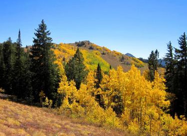 |
You're now on the Wasatch Crest. For about a mile, it will
be doubletrack, then change to singletrack as you pedal through meadows
and groves of trees on the spine of the Wasatch.
Wasatch Crest, photo by Rodney Strader
in 2010. |
| When you descend The Spine above Desolation Lake, keep right
at the fork and begin climbing again to stay on the Wasatch Crest (mile
12.3). (The trail on the left descends to Mill D North Fork in Big
Cottonwood.)
Looking from the Wasatch Crest toward
Solitude, photo by Rodney Strader in 2010. |

|
 |
As you reach the top of Mill Creek Canyon at mile 14.8,
there will be a trail fork in a small meadow. Take the right fork to the
edge of the ridge. You're now heading east and looking into The Canyons
area of Park City.
Desolation Lake, photo by Rodney
Strader in 2010. |
| This is the Crest Connector Trail. It will traverse a steep
side-slope, cross a ridge, then descend through thick forest down to the
Midmountain Trail. As you reach the trail fork, keep right and head south.
(2011: You'll skirt some construction areas. Keep generally straight
and watch for the continuing singletrack.)
Crossing the ridge on the Crest
Connector Trail. Photo 2010 by Bruce.
|

|
 |
At Red Pine Lodge at mile 18.6, you can hit bathrooms, get
water, and have a restaurant meal. You're more than half-way done, but
there's still some serious riding ahead.
At mile 21.8, Midmountain continues straight (left) while Ironman
switchbacks up and over Iron Mountain Pass. You can go either way. We
assume you stayed on Midmountain.
Arriving at the Midmountain Trail,
heading south. |
| At mile 23.6, just after reversing direction abruptly,
Midmountain forks hard left. (Right takes you up to Iron Mountain Pass.)
What follows is some hateful rocky rough newly-built trail. It will get
better. You'll rejoin Ironman at mile 25.1.
Typical trail scene on Midmountain,
near Red Pine Lodge.
|

|
 |
At 25.6, stay right uphill as Armstrong joins from below.
(Armstrong is a one-way trail -- uphill only.)
At 27.5, turn downhill left as Powerline forks off Midmountain on the
right. Now take an immediate right turn to stay on Midmountain. (Straight
downhill = Spiro.)
View along the Midmountain near
Holly's Trail. |
| Intersections and trail forks are now nicely marked for the
return trip. Even if it doesn't tell you what the "other" trail
is, there's usually a sign indicating Midmountain. In general, just stay
straight and level.
Rider southbound on Midmountain near
the Empire Link trail fork.
|
|
Riding notes, clockwise loop from Silver
Lake Lodge:
0.0 R downhill on DT, aim for underpass
N40 37.284 W111 29.326
0.1 L on singletrack (Midmountain Trail)
N40 37.267 W111 29.330
0.7 Keep L uphill (R = lower Tour des Suds)
N40 37.146 W111 29.754
1.0 Keep L uphill N40 37.177 W111 29.842
1.4 L uphill on Team Big Bear N40 37.111 W111 30.155
2.4 Keep straight (don't go onto road)
N40 36.894 W111 30.031
2.8 Keep R (Flagstaff Loop) N40 36.768 W111 29.880
3.1 L on DT Ruby Lift Road N40 36.537 W111 29.969
3.3 Keep L (R = to Ruby Lift)
3.7 Cross Guardsman Rd, through parking to DT
N40 36.390 W111 30.432
3.9 Stay on DT (R = to upper TG) N40 36.402 W111 30.654
4.6 Veer R off DT onto ST N40 36.565 W111 31.248
4.8 L uphill on DT N40 36.580 W111 31.505
4.9 Turn R corner, then straight and L level westbound DT
N40 36.561 W111 31.512
5.2 Join gravel Guardsman Rd westbound
6.1 DT joins on R, keep straight
6.5 Guardsman Pass Parking
R uphill on DT (leave Guardsman
at parking area)
Start Scott's Bypass N40 36.410 W111 33.294
6.9 L off DT onto ST N40 36.715 W111 33.392
7.9 Scott's Pass, uphill to L on DT
Wasatch Crest
8.2 Top of Puke Hill
12.2 Desolation Lake, The Spine
12.3 Keep R uphill (L = Mill D No)
N40 39.560 W111 35.845 |
14.8 R to Crest Connector N40 41.204 W111 36.072
(L = Mill Creek)
15.1 Straight
16.0 Join Midmountain, keep straight (R)
N40 41.488 W111 35.134
18.6 Red Pine Lodge, keep straight through
N40 40.658 W111 34.675
21.8 Keep L on MidMtn (R = Ironman) N40 39.625 W111 33.364
23.6 Hard L (R connects to Ironman) N40 40.060 W111 32.490
25.1 Keep L (R = Ironman) N40 39.299 W111 32.306
25.6 R uphill (L = Armstrong) N40 39.099 W111 32.288
27.5 L downhill (R = Powerline) N40 37.963 W111 32.180
Then rapid R on Midmountain
28.3 Stay L (R= Crescent M.G.) N40 38.182 W111 31.514
28.4 Cross road
30.2 L downhill N40 37.875 W111 30.915
30.3 R onto ST N40 37.906 W111 30.839
30.4 R uphill N40 37.860 W111 30.896
30.6 Cross gravel road N40 37.788 W111 30.799
31.1 Stay R uphill (L = Empire Link)
N40 37.658 W111 30.894
31.7 Level straight N40 37.492 W111 30.993
(Link in on L, Link leaves
downhill R)
31.8 Straight (L=TG) N40 37.517 W111 30.932
32.5 Little Chief joins L, keep straight
N40 36.949 W111 30.828
32.6 Cross DT N40 36.882 W111 30.770
32.9 Keep straight (L=to TG) N40 36.821 W111 30.594
33.2 Cross Guardsman Road N40 36.979 W111 30.451
33.3 Keep straight (L=Tour des Suds)
N40 37.023 W111 30.400
33.5 Straight (Team Big Bear) N40 37.111 W111 30.155
34.9 Back at Deer Valley |
 |
Getting there: In Park City, follow the signs
toward Deer Valley Resort. To get to the upper (Silver Lake) lodge, turn left on Royal Drive just
after the road divides -- before you actually see the Snow Park lodge.
Drive 4 miles uphill, following the signs. When you come to a parking lot
on your right, surrounded by tall buildings, pull in. From the lot, angle
southeast between buildings until you arrive at a wide open area. Your
ride will start by aiming right, coast downhill to below the underpass. As
you pass under, turn left onto singletrack. This is the Midmountain Trail.
Bike services, water, bathrooms are near the lift by Silver Lake Lodge.
On the ride, you'll pass the Red Pine Lodge at The Canyons, where you'll
find food, water, and bathrooms. |
|


