 |
Windy Pass Trail
(Great Western, South Fork of
Provo Canyon)
The Windy Pass Trail climbs from the South Fork of Provo
Canyon to a high ridgeline called Windy Pass. It begins smoothly at the
Big Spring trail, then becomes steep and rocky. Starting at 5700 feet
altitude, you'll climb 3300 vertical feet to the pass. Out-and-back, it's
13 miles round trip.
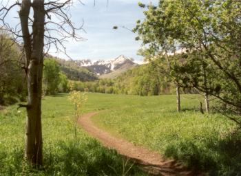
Looking up the canyon. We'll do a hard
left at the base of the snow-covered mountain, then climb up and around
the hill at left to the top of the ridgeline behind it. All photos by Bruce, May 28, 2002.
|
|
Because of narrow trail, loose rock, and injury
potential, I'm rating this trail advanced technical, very strenuous
aerobic. This is not an easy trail.
Even if the trail is buffed,
you'll be climbing at a rate of about 800 feet per mile once you join the
Great Western.
The trail starts on the Big Springs
Loop. This section is smooth and buffed.
|
|
| I found the trail cratered and churned from horses, with
many long sections of loose rock that made climbing a challenge and
descent "endo city." I'd reserve this trail for an advanced
rider (with good rock-surfing control) who's looking for a climbing
challenge. If that's you, go for it. |
 |
The trail alternately passes through Gambel Oak and Mule's
Ear on hot hillsides, then plunges into pines, maples, and quakies. There
are choke cherry, serviceberry, and elderberry along the trail. In the
trees, the ground is covered with dwarf waterleaf and oregon grape. In one
section, clematis vines bloom as they climb the trailside brush.
Serviceberry blooms along the trail.
In September, these are a tasty treat. |
|
\In the sunny areas, mule's ears and penstemon bloom in late spring.
You'll also see scarlet gilia (desert trumpet) and desert parsley. This is
a pretty ride, if you can take your eye off the treacherous trail for a
second.
If you choose to continue beyond the pass, you'll climb
another 200 feet elevation, then begin dropping towards Bald Knoll. The
trail links up with Forest Road 121 about 6.5 miles beyond the pass. This
road drops into Wallsburg. Most riders who are doing a shuttle ride,
however, do the ride in the opposite direction: from Wallsburg to Vivian
Park. This saves a few hundred feet of climbing, and is (I'm told)
significantly easier.
Smoother trail section about half-way
up, with serviceberry growing among quakies.
|

|
 |
The difficulty of this trail will depend on the season, and
on whether grooming (raking loose rocks) has been done. It's not your
Momma's trail. Ride it.
View north near the pass, looking
towards Lone Peak. Timpanogos is on the left.
|
|
Photo: Mule's Ears bloom among oak
brush on the lower trail. Mount Timpanogos peeks above the next rise. |

|
Riding notes:
0.0 Singletrack on far end of parking lot (E 5700)
0.85 Fork L, cross road
1.15 Fork L GPS N 40° 19.192' W 111° 31.874' (E 5900)
Go down and through gully
(R=Big Spring)
1.6 Keep R (L goes downhill to GW trailhead)
1.9 Great Western comes in on left
GPS N 40° 19.369' W 111°
31.391' (E 6300)
|
4.6 Fork L (R=Shingle Mill Trail) to go east
GPS N 40° 17.528' W 111°
31.842' (E 7600)
5.6 Hard R to go south (E 8200)
6.15 Trail turns back east (E 8700)
6.4 Keep R uphill, begin stiff climb at Water Hollow
GPS N 40° 17.103' W 111°
30.593' (E 8800)
6.55 At pass (if continuing to Bald Knoll, go L)
GPS N 40° 17.026' W 111°
30.617' (E 9000) |
 |
Getting there: In Provo Canyon, turn south (right if
you're going uphill) on the South Fork road at Vivian Park. Drive 3.1
miles and turn right at the National Forest access. Go to the big parking
lot at the end. The singletrack trail starts at the hole in the fence at
the north end of the parking lot. GPS N 40° 19.952' W 111° 31.487'.
To start at the horse trailhead, continue up the South Fork road
another 0.9 mile. Pull right into a gravel parking area just before the
gate of the Trefoil ranch. The trail starts at the gate with 0.8 miles of
doubletrack. GPS N 40° 19.540' W 111° 31.074'. This route saves about a
mile of distance but only about 150 ft of climbing. I don't recommend it
for bikes. |
|


