 |
Bonneville Shoreline Trail
Rattlesnake to Grandeur Peak Section
(includes Rattlesnake Gulch expert trail)This section of the
Bonneville Shoreline Trail (BST) extends from the Rattlesnake Gulch
trailhead in lower Mill Creek Canyon to the Grandeur Peak
trailhead on Wasatch Blvd at the mouth of Parley's Canyon. As of July
2022, the Rattlesnake portion is complete, up to the viewpoint at the west
end of the Pipeline trail. Looking
north as we climb the switchbacks of Rattlesnake BST. Review and photos by
Bruce on July 5, 2022. |
| At this time -- July 2022 -- the
central (Grandview) section is still under construction. You can ride each end as an
out-and-back. This page will be updated as construction progresses.
The Old Quarry Road (aka Parley's Bench trail) goes one mile south from
the Grandeur Peak trailhead. The segment from the southern end of the
Parley's Bench trail to the Pipeline trail is still under construction.
This page will be updated once the full trail is ready to ride, probably
fall 2022.
A tame spot on the Rattlesnake Gulch expert trail, an
alternate descending route. |
|
 |
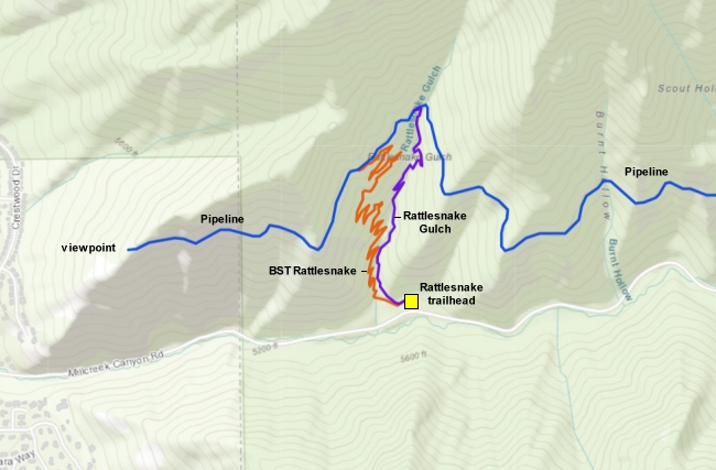
Rattlesnake Gulch
The Rattlesnake trailhead is 1.5 miles up the Mill Creek Canyon road
from Wasatch Blvd. There are bathrooms. The trailhead is located about 3/4
mile uphill from the fee station. (Mill Creek Canyon is a US Forest
Service fee area for vehicles. Bikes are free.) There's room for around 20
cars here, but it will fill up quickly on weekends. The combined
Rattlesnake Gulch and Rattlesnake BST start on the west side of the
parking lot, but separate within 100 yards with the BST forking left from
the larger Rattlesnake Gulch trail.
Rattlesnake Gulch trailhead, looking north. The trail
starts at the sign. |
 |
Grandeur Peak
The Grandeur Peak trailhead is at the far north end of Wasatch
Boulevard. The Old Quarry Road trail heads east uphill and will link to
the new BST in around a mile. There are no services at this trailhead.
(This segment is NOT
complete at this time!)
This trailhead also lets you take the paved lower BST
(Bonneville Shoreline Trail) from the southern side of Parley's Canyon
mouth. You'll cross the I-80 on-ramp road and I-80 itself on bridges, then
connect to the Old Parley's Road trail which takes you to the southern end
of the Parley's Pointe BST section. The trailhead has room for around 15 cars including
roadside parking.
Grandeur Peak trailhead, looking north. |
 |
The Rattlesnake BST was completed in fall 2021. It's an
intermediate-level ride, 1.4 miles in length with 600 vertical feet of
climbing.
At Mill Creek Canyon's Rattlesnake Gulch trailhead, the combined
Rattlesnake Gulch and Rattlesnake BST trails leave the western side of the
paved parking area, just north of the bathrooms. After around 100 feet,
the BST forks away to the left at a break in the log fencing. (In July
2022, signs have not yet been installed.)
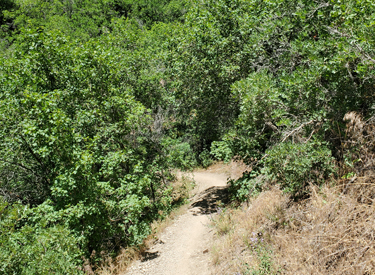
View up the BST shortly after splitting away from
Rattlesnake Gulch. |
| The trail begins climbing through a forest of oak, box
elder, and maple. The forest gives way to open grass with groves of oak on
a south-facing hillside. It will get quite warm on a summer's afternoon.
The trail surface is smooth dirt with areas of loose limestone
chunk.
Looking northeast toward the top of Grandeur Peak.
|

|
 |
The Rattlesnake BST will gain 600 vertical feet, from 5350
to 5940 feet elevation. This occurs over 1.4 miles. I recommend this trail
for intermediates or better, but strong beginners can make the trip if
they walk their bikes around the switchback turns.
The rate of climb will
be tough for many intermediates, especially with the tight switchback
turns that often have a bed of loose limestone chunks in the turning path.
View west toward the mouth of Mill Creek Canyon as we
climb up the switchbacks. |
| There will be views down into Rattlesnake Gulch, but there
aren't open sight-lines out to the valley or to upper Mill Creek Canyon.
These will have to wait until you reach the Mill Creek Pipeline
trail.
Looking down to the bottom of Mill Creek Canyon in
the bowl of Rattlesnake Gulch.
|

|
 |
At mile 1.4 from the trailhead, the Rattlesnake BST joins
the Pipeline trail. If you keep straight, it's
0.7 miles to the viewpoint over the valley. The Grandeur Peak segment will
tie into the trail here once it's completed.
If your destination is uphill, a hard right will take you northbound on
Pipeline. The expert-level descent down Rattlesnake Gulch is 0.3 miles
away (see below). It's 3.9 miles to the Burch Hollow trailhead, and 6.5
miles to Elbow Fork. At Elbow Fork 100 yards uphill on pavement connects
you to the Upper Pipeline, which takes you to Big
Water.
On the Pipeline trail at the top of the Rattlesnake
BST. |
Mill Creek Pipeline to viewpoint |
 |
If you keep straight and left at the top of Rattlesnake BST,
you'll head west toward the Salt Lake Valley on the Pipeline trail. It's 0.7 miles to the
viewpoint.
Heading west on the Pipeline with Mount Olympus
coming into view. |
| The Pipeline is flat because it follows the path of an old
water pipe. There's almost no elevation change as you ride west.
For now, you'll need to turn around at the viewpoint. The Grandeur Peak
section down to the Old Quarry Road trail is not yet complete.
Almost to the viewpoint.
|

|
| This section of the trail is not
complete. I will add it to this page once it's legal for me to ride it. |
Rattlesnake Gulch Trail (alternate descent) |
 |
The classic Rattlesnake Gulch trail forks away from the Mill
Creek Pipeline 0.3 miles from the top of the BST. This trail will drop the
same 600 vertical feet as the BST, but it does so in only 0.7 miles.
There are two entries into Rattlesnake Gulch, one on
each side of the ravine. This is the west entry. |
| This is an expert-level descent, with large embedded rocks,
tight switchbacks, and log water-bars on a slope that averages 15%. In the
technical areas the trail tends to be wide -- as hikers and bikes have
dodged the obstacles over the years -- so you've got a few choices in
picking your line.
Photos don't do justice to the boulders and slope of
the descent.
|

|
 |
In the old days, we used to climb up Rattlesnake Gulch with
a bit of grunting and a lot of hike-a-bike. But with the completion of the
BST, there's absolutely no reason to pedal up this trail.
Coming into a switchback. |
| Remember that hikers will be strolling up this trail. Keep
your speed in check. Dust and loose pebbles make stopping difficult if
you're riding fast. The log water-bars are one of the few spots where
there's enough sight-line and mild enough slope to hop up in the air and
safely recover.
On the lower slope, we're approaching two water-bars.
The closer one is around 18 inches in height, suitable for a quick huck or
even a fast roll-over.
|

|
 |
As you approach the trailhead, the trail mellows. When
you're looking uphill as you first start your ride up the BST, it might
sucker you. Rattlesnake Gulch gets nastier the higher you go. So don't
climb it.
Rolling into the trailhead. |
 |
Bottom Line: Good climbing option to get up to
the Pipeline, for intermediate riders or experienced conditioned
beginners.
Getting there: Get to Foothill Blvd on the east bench of
Salt Lake City via I-215. Exit at 39th South. Take 3800 South (Mill Creek
Canyon Road) eastbound into the Canyon. In 1.5 miles, turn left into the
Rattlesnake Gulch trailhead.
Note: Mill Creek Canyon is a fee area for vehicles. On
exiting the canyon, you'll need to pay $5 (2022 fee) by credit or debit
card.
This map will be expanded to show the northern side
of this BST segment once construction is complete. |

|


