 |
Chop'd Coyote Trail
(Coyote Middle)
This trail is located north of Heber in the Riverview and
Coyote
Canyon riding area. This 4.9 mile trail links the middle of Upper Riverview trail
to the backside of the Coyote Loop. It chops the Coyote Loop in half. The
trail is not technical but it's a substantial climb and recommended for
intermediates or better.
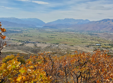
View of the Heber Valley from Coyote
Middle on June 5, 2015.
|
|
You'll need to climb 1.6 miles from
the UVU Wasatch Campus trailhead to reach Upper Riverview, then head south
0.4 miles to find Chop'd Coyote. As an out-and-back, that's 13.8 miles
with 1700 vertical.
Most riders though, use Chop'd Coyote for shorter versions
of the Coyote Loop. Chop'd Coyote's reason-for-being is to split the Coyote Loop
into two shorter rides. But they won't be as short as you'd think, and you
really won't skip much climbing.
Terrain on the west side of the hill
-- mostly sage, a bit of oak, and cactus on the lower altitudes.
|

|
 |
Below, I describe a southern half-loop that goes from the UVU trailhead up
Chop'd Coyote, southbound and down Coyote and returning via the sagebrush
singletrack near the canal. It's 17.3 miles (compared to 24 for the full
loop). Climbing is 1900 vertical.
The northern half-loop is from the Riverview trailhead on highway 32,
going clockwise to drop Chop'd Coyote, then back via Riverview. This route
is 16 miles with 2100 feet of climbing. The northern half-loop offers
several variations to increase or decrease the mileage in the Cutthroat
area.
Handlebar view from the ridge, looking
west toward Cascade Mountain and Timpanogos.
|
| The terrain is mostly sage brush with small stands of short
gambel oak. The slope is sun-exposed after early morning, and tends to get
hot in summer. As the trail zigzags cross the mountain face, there are
constant views of the Heber Valley.
After crossing the first ridge, we're
approaching the doubletrack road, which lies at the bottom of this valley.
|

|
 |
The trail track is machine excavated, so it's broad and flat.
The turns have been worked so they're
smooth and flow well for climbing. But when riding downhill, there are a lot of switchbacks that are
quite tight or
that don't have a decent run-out. It's not a high-speed descender.
Another look across the Heber Valley toward Deer
Creek and Provo Canyon in October.
|
| In 2022, there's one connecting trail while riding Chop'd
Coyote. The top of Lonely Mountain forks away from Chop'd
Coyote at 2.2 miles from Upper Riverview if you're using Chop'd Coyote
as your uphill.
When descending Chop'd Coyote from the Coyote Loop at the
top of the mountain, it's 2.7 miles from Coyote to the Lonely Mountain
fork. Lonely Mountain can take you down to Mordor for an expert-level
continued descent, or to Upper Potatoes for an intermediate downhill.
Riding through a grove of tall oak as we approach the
Coyote Canyon dirt road near the top of Chop'd Coyote.
|

|
 |
On the uphill climb, you'll cross a first ridgeline, then
descend slightly as the trail turns north into a valley. After crossing
the Coyote Canyon road, the singletrack continues uphill to reach the
Coyote Loop on an sagebrush-covered ridgeline.
It's not ALL oak brush and sage.
There's one, yes one, grove of aspen and maple.
|
| One option for a shorter loop ride on the northern half-loop
of Coyote is to use the newer
Looney Tunes trail. This cuts two miles
and 200 feet of climbing off the loop. Another fun option on the
northern half-loop is the Sufferin Succotash
trail down to Wile E Canyon. The top of Sufferin Succotash is on the
Coyote Loop, 100 yards north of where Chop'd Coyote joins it.
High on the mountain, with Timpanogos and the Heber
valley below.
|

|
Southern Half-Loop clockwise from the UVU
TH:
0.0 Step-over gate at kiosk, up ST
N40 32.782 W111 24.752
0.1 Uphill over canal, immediate left
N40 32.837 W111 24.615
0.4 Straight across DT Lower Riverview
N40 32.935 W111 24.533
1.6 Right on Upper Riverview N40 33.207 W111 24.238
2.0 Hard L uphill on Coyote Middle (Chop'd Coyote)
N40 33.064 W111 24.042
6.5 Join DT (Coyote Lane) uphill
N40 34.206 W111 23.733
6.7 Right (dirt road) N40 34.313 W111 23.854 |
6.8 L 80 ft N40 34.352 W111 23.779
to Coyote
Go R on Coyote N40 34.368 W111 23.773
7.3 Cross dirt road N40 34.290 W111 23.473
14.2 Fork L (R = to Riverview) N40 32.364 W111 23.405
15.2 Cross DT (Coyote Lane) N40 32.184 W111 23.741
15.4 Fork R N40 32.121 W111 23.816
15.6 Fork R N40 32.128 W111 23.928
15.8 Fork L (R = Freefall) N40 32.158 W111 23.983
16.1 Join dirt road northbound N40 32.387 W111 23.921
16.2 Veer L onto ST N40 32.405 W111 23.990
17.1 L across bridge N40 32.837 W111 24.615
Immediate R to ST, descend to
TH
17.3 At parking |
Northern Half-Loop clockwise from Riverview (Hwy 32) TH:
0.0 Trail at downhill end of parking
N40 34.404 W111 25.215 Take stairs over fence
0.3 Keep L for Coyote (R = return) N40 34.430 W111 25.062
4.5 Cross DT N40 35.353 W111 23.617
4.55 Fork R (L = to highway 32) N40 35.329 W111 23.601
7.6 Unmarked, R 80 feet to DT N40 34.366 W111 23.772
R downhill on DT |
7.7 L downhill on Coyote Lane N40 34.314 W111 23.853
7.9 Veer R on Chop'd Coyote ST N40 34.205 W111 23.733
12.5 Hard R on Upper Riverview N40 33.064 W111 24.042
12.9 Keep R (L = to UVU TH) N40 33.205 W111 24.240
14.6 Keep R (L = viewpoint) N40 33.704 W111 25.007
15.7 Keep R (L = Sheep Bones) N40 34.321 W111 25.058
15.8 Fork L N40 34.432 W111 25.066
16.1 Back at parking |
|

|
Getting there, Riverview Trailhead:
From Salt Lake, take I-80 eastbound to Silver Creek Junction (just
past Park City). Go south on US-40, past the Jordanelle reservoir and
descend past the dam. At the traffic light at mile 14.2 from I-80, turn
left on 32 and climb 1.1 miles. When you see the second entry into
Riverview on your left, note the gravel parking area on your right N40 34.403 W111 25.214. That's
your spot.
From Utah County, drive up Provo Canyon to Heber. At the traffic
light on US-189/US-40, turn left and drive north through Heber. 4.7 miles
from the intersection, turn right on Highway 32 and climb 1.1 miles to the
parking area as above.
UVU Wasatch Campus Trailhead:
One mile south of the junction of
Highway 40 and 32 (a couple of miles north of Heber), turn east (toward the mountain) at the UVU campus.
Go to the uppermost level of parking behind the UVU buildings. Look for the
duck-under and kiosk N40 32.798 W111 24.735. A singletrack trail climbs 1.5 miles to the
Riverview Trail.
Coyote Trailhead:
Two miles south of the junction of Highway 40
and 32, turn east (toward the mountain) on Coyote Lane. Just after the
road crosses a canal, turn left into the parking lot. The singletrack
starts at the northeast corner at the step-over, where you'll also find a
repair stand and a kiosk with a trail map. The Coyote singletrack takes
you uphill. After merging with the gravel road to cross the bridge, veer
left onto singletrack then keep generally right and uphill at the trail
forks.
Cutthroat (Highway 32) Trailhead:
Drive up
Highway 32 four miles. Look for a gravel road on the right side N40 35.430 W111 23.389. You can
park along the road and clamber over the fence near the (locked) gate.
Find the singletrack on your left and ride uphill, keeping to the right at
the Wile E Canyon fork about 100
yards uphill. You'll reach the fork that starts the Coyote loop 0.4 miles from the
highway.
Canal DT trailhead:
Just uphill from the light on highway 32, watch
for the canal crossing. Park along the road. Start riding south on the
doubletrack just uphill from the canal.
Coyote area trail pages: Riverview Trail
page Lower Riverview page
Coyote Loop page
Isengard/Mordor page Chop'd
Coyote page
Cutthroat
(Wile E Coyote and Looney Tunes) page
|
|


