 |
Moosehouse Loop
Daly Grind to Ontario Ridge to Empire Link to Johns 99 to Moosehouse
to Gravedigger
This is a six-mile loop in Park City's Daly Canyon with about 1000
vertical feet of total climbing. It's intermediate overall in tech requirement and
is a fairly fast ride. Most cyclists could complete it in about an hour.
For advanced cyclists, there are alternate lines down Moosehouse that are
steep, hairy, and offer jumps. The "regular" descent on
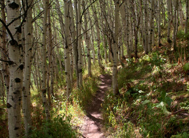
Moosehouse is upper-intermediate tech. A
cruising spot on Johns99. Photos and track by Bruce on September 15, 2011. |
| Most of the ride is in forest, with rare breakout views. It
starts well uphill in Daly Canyon at 7300 feet elevation, climbing to a
top altitude of 8150 at the intersection of Empire Link with Johns99. The
most technical sections is the descent down Moosehouse.
Heading west through forest just after
leaving Tour des Suds on Empire Link.
|

|
 |
The ride starts at the spot where the Daly Canyon road (the
continuation of Park Avenue) turns from pavement into dirt. Climb up the
doubletrack, called Daly Grind, for only a short distance. Watch on the
left for a trail heading up the hill on the left side of the creek at mile
0.2. As of 2011, broad stones provided a path across the creek.
The first half of Empire Link has dark
fir forest and smooth undulating surface. Great cruise.
|
| Climb up into the trees and turn left to go north. When you
hit a trail fork at mile 0.5, turn hard right to head back south on a
gentle upslope. (Note: the right fork takes you up to the Prospect Trail
on the ridgeline. At the point where it connects, a trail descends the
opposite side of the mountain that connects to the Rossi Hill trail and
Deer Valley.)
Keep straight (right) at the next fork. When you arrive at doubletrack
at mile 0.8, turn left uphill and climb around the turn. Just after the
dirt road turns sharply right, note a broad path on the right (m 0.9).
There should be a "Tour des Suds"
trail sign there.
Approaching the ski lift in Daly
Canyon, where we'll intersect the doubletrack Daly Grind before climbing
the opposite hill.
|

|
 |
The broad path will turn to singletrack. Stay on the main (flat, straight, and level) trail. A couple
of trails fork rightward uphill or sharply downhill. When you pass a trail coming uphill
towards you on your left at mile 1.4, it's time to turn hard to the right
and climb up to the next trail intersection.
The opposite (western) side of Empire
Link is sunnier and warmer as we climb through the aspens. |
| At the 4-way at mile 1.5, keep straight (as Tour des Suds
turns to the left). At a trail fork a few feet later, either way will get
you there. The official route is uphill left.
At mile 1.8, keep straight (right). The trail to the left climbs up to
the paved Guardsman Road. Now comes a mile of delicious cruising in the
trees.
We join Johns99 in an area of deep
conifer forest. |

|
 |
At 2.8, cross the Daly Grind DT and climb the singletrack on
the opposite side. The terrain changes from aspen and fir to aspen and
maple.
At mile 3.0, the Speedbag Trail crosses. It's a small trail, so you
might not notice. Keep straight.
The top section of Moosehouse twists
through aspen and scrub forest at a mellow slope. |
| The Empire Link Trail will now cross Johns99. As the trails
merge, keep straight at mile 3.6, then turn right on Johns99 as Empire
Link keeps climbing to the Midmountain Trail.
Cruise on Johns99 for 1/2 mile. At mile 4.3, Johns99 hits the gravel
King Road. Turn right downhill on the road and go about 100 feet to the
top of Moosehouse on the right side.
As we hit the steeper slopes, DH
trails cross. When in doubt, keep straight and take the most level trail. |

|
 |
Moosehouse wanders through aspen before plunging through fir
forest. Keep right at mile 4.4 as the trail splits around a tree. Now stay
on the most level path as downhill trails cross.
At mile 4.9, turn right on Gravedigger as Moosehouse crosses it. Follow
Gravedigger along the mountainside through forest of oak and maple.
Moosehouse breaks out into the open
near Gravedigger, with a view of the homes near the Silver Lake Lodge
area. |
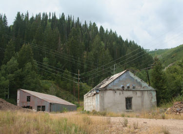
| The trail will descend to a mine site in Daly Canyon. Pick
your way past the fences and buildings, then veer left to follow the main doubletrack
around 180 degrees. (Don't go uphill on either dirt road.) Before you get near the water tank, however, head left
on a singletrack that crosses over to the left side of the canyon, just
below the break of the hill.
Heading south on Gravedigger. |

|
 |
Follow the singletrack (taking the jumps and stunts if
you're inclined) until it dumps onto the road. Head downhill, around the
gate, and back to the roadside parking area.
At the bottom of Gravedigger, we pass
old mine buildings. |
Riding notes, clockwise loop:
0.0 Uphill on gravel road N40 37.957 W111 29.837
0.2 Left into trees on ST N40 37.800 W111 29.992
0.5 Hard R to go south N40 37.978 W111 29.772
0.7 Keep straight (R) N40 37.812 W111 29.877
0.8 L uphill on DT N40 37.771 W111 29.911
0.9 R to Tour des Suds N40 37.786 W111 29.814
1.4 Hard R uphill N40 37.549 W111 29.927
1.5 Straight on Empire Link N40 37.593 W111 29.935
(L = Tour des Suds)
Then L uphill N40 37.599 W111 29.953
1.8 Keep R (L = to road) N40 37.454 W111 30.119
2.8 Cross DT (Daly Grind) N40 37.357 W111 30.508
3.0 Keep straight (Speedbag crosses)
N40 37.470 W111 30.509 |
3.6 Merge Johns99, then R on Johns99
N40 37.580 W111 30.854
4.3 R downhill on gravel road N40 37.823 W111 30.333
Then R on ST Moosehouse
N40 37.836 W111 30.310
4.4 Keep R N40 37.864 W111 30.250
4.9 R on Gravedigger N40 37.954 W111 30.005
5.4 Merge w DT N40 37.619 W111 30.253
5.5 Curve left N40 37.558 W111 30.260
5.5 ST on L crosses to opposite side
N40 37.595 W111 30.196
5.7 ST joins road
6.1 Back at car |
Getting there:
As you drive into Park City, you'll arrive at the "main"
intersection of Park Avenue and Kearns Blvd. From the light, head
south on Park Avenue (straight ahead if you came from I-80, a left
turn if you arrived on Kearns Blvd from US-40). Keep going through town.
Just after the road veers a little to the right, it becomes narrower. As
you reach the end of the homes and pavement, find parking on your left
along the creek. Start the ride by continuing up the dirt road the
direction you were driving. |

|
|


