
|
Tour des Suds
The Tour des Suds is one of the best-known classic Park City trails.
Fifteen years ago, Tour des Suds was probably the most famous trail
in Utah, and for good reason. It was an awesome ride. Was. Over the last
10 years, Tour des Suds has been chopped up and rerouted as the bulldozers
prepared the mountain for pavement and expensive homes.
Yes, it's
still worth riding, but you'll wonder why Tour des Suds deserves a
"classic must-ride" designation. History. And Tour des Suds has
an annual race named after it.
Mike
rips through along Tour des Suds in July 2002. Latest update 2011
by Bruce.
|
| Tour des Suds is a good route uphill if you're doing a big
loop ride starting in downtown Park City. Westbound from the top of Tour
des Suds are trails
such as TG, Midmountain, and
Johns99. To the east the Flagstaff Loop
connects to the
trails of Deer Valley such as Naildriver, Deer Crest, etc.
Most riders nowadays do only the last section of Tour des Suds, a short
segment above
the Midmountain Trail. OK. But here I'll be describing the classic start
from town.
Climbing the dirt road out of Daly
Canyon to start the Tour. |

|
 |
The ride starts at Daly Canyon as you climb south up gravel
doubletrack. There's an alternate singletrack in the trees at mile 0.25.
You can bypass much of the doubletrack in the first 1.5 miles by hopping
singletracks. Once you know where the trail ends up, the singletrack
options are lots more fun.
As the gravel road passes the water tank, turn left uphill and reverse
direction. At the top of hill as the road turns to the right, watch for a
doubletrack signed for Tour des Suds on the right. It becomes singletrack
after about 100 yards.
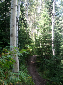
Even lower on the mountain, there are
some surprisingly lush areas of forest. Photo 2011. |
| There will be multiple side routes. Most of them are used
for the downhill return. Keep on what looks like the main route and stay
generally southbound. If you don't know where you're going, follow the GPS
track I've provided.
When the trail hits paved road, go uphill a bit and find singletrack on
the opposite side. There are multiple interconnecting trails on this rocky
slope. Blunder your way uphill about 100 yards to the continuing climb.
Here Bruce climbs out of the
trees onto doubletrack in 2001. |

|
 |
The trail slowly zigzags uphill. When you hit the
Midmountain Trail (unmarked intersection as of 2011), turn right
(westbound). Now ride the flat Midmountain. Pass Team Big
Bear, uphill on
your left. (A new trail-cut angles down from Team Big Bear toward a ski
lift and lodge.) About 1/3 mile later, Tour des Suds forks uphill to the left.
(There's a trail on the FAR left at the junction which is a DH from the
Ruby Lift. You can ride a loop linking TG to Empire
Lodge at the bottom of Ruby.)
Higher up on the mountain, we're
leaving the Midmountain Trail and climbing southwest on Tour des Suds. |
| This section of Tour is pretty buff with a fairly easy
grade. It makes a nice climbing route, although it's not as nice as the
old version. And it's over too quickly. Most of the trail is in forest, with aspen, choke cherry,
and fir.
When you hit gravel road, you have options: (1) Head right on gravel to
the paved road, then climb uphill on pavement to the TG trails or Moose
Bones. (2) Head left a half mile or so and catch Moose Bones to ride west.
(3) On the dirt road, go left around the corner and grab Team Big Bear
when it skirts the edge of the road about 1/10 mile later.
Looking at the greenery surrounding
Dominic as he climbs the mountain, it's easy to see why Tour des Suds has
been so popular. |

|
 |
Westbound through Moose Bones:
After reaching the gravel road via Tour des Suds, fork left on the road.
Pass the spot where the Ruby-to-Empire DH crosses. As the road turns 90
degrees left, spot two trails. One goes straight ahead. (Note 2011: the
straight-ahead singletrack trail is blocked by construction. Yeah. Old
story.) The ST that heads back west uphill is Moose Bones. Hop on it.
Heading west on Moose Bones. |
| Moose Bones will also be crossed by the Ruby-to-Empire DH route.
Cross one paved road, and at the next paved road, head straight and
slightly downhill 0.1 miles and find the singletrack TG trail at the turn
in the road. (The doubletrack heading uphill takes you to the ridgeline,
where you can connect to an upper singletrack that reconnects to TG
further on.)
Passing across one of the ski runs
from the Ruby Lift as we head toward TG on Moose Bone. |

|
 |
The TG trail will take you northwest. I'd recommend
this loop to advanced riders. TG will descend to the Midmountain Trail,
where you can connect to the multiple trails of the Park City Mountain
Resort area. A loop up Tour des Suds, north through TG and
John's 99, then back via John's and Gravedigger will be 13.5 miles. Altitude change is 1500,
with a peak of 8900; total climbing around 2200.
Entering the deep forest of the TG
trail. |
| Like most routes on the west side of Park City, navigation
can be confusing due to multiple trail intersections. If you get on the wrong trail, don't sweat it. The city's right below
you, so you can't stay lost. If you find a busy-looking trail intersection
and wait a few minutes, chances are another biker will point you in the
right direction. I strongly recommend you take both a current
MountainTrails.org map and a GPS track.
Dominic crosses a field of blooming
wyethia as we near the Midmountain Trail on TG. |

|
 |
Eastbound through Team Big Bear:
The eastbound loops pass through Team Big Bear. (You also have the option
of simply dropping down Team Big Bear to Midmountain for a quickie loop
ride.) At the 90-degree turn described above, follow the road for another
0.1 mile and find the singletrack on the left side of the road. Staying
straight takes you uphill; reversing 180 degrees takes you downhill on
Team Big Bear.
Riding on the Flagstaff Loop toward
Bald Mountain for an eastbound loop. |
| Team Big Bear ends at the Flagstaff Loop. Take either fork.
As you reach Deer Camp, keep heading east uphill to the shoulder of Bald
Mountain where riders are descending from the lift. If you have time,
consider riding the Bowhunter Loop. Now decide on your downhill route.
There are dozens of routes downhill at Deer Valley. Homeward Bound, with
its multiple man-made stunts, is a great choice.
Entering Homeward Bound to descend
back to Silver Lake Lodge and the Midmountain Trail. |

|
 |
From the Silver Lake lodge area, you can catch the
Midmountain Trail back to Tour des Suds to return to town.
When Tour des Suds hits the dirt road in Daly Canyon, consider taking
the Prospect Trail along Ontario Ridge. It's on the left at the corner
where you originally turned onto Tour des Suds. Yes, Prospect is straight,
boring, and (in 2011) loaded with annoying babyhead rocks. But it's
singletrack instead of dirt road. You can also connect to the lower Deer
Valley lodge by forking off onto the Rossi Hill
trail.
Cruising downhill past old ruins on
Prospect. |
| To navigate Prospect, just keep straight as you rocket down
the ridgeline. Alternate lines will drop off left and right. When you hit
paved road on Prospect, take the next road left downhill to descend to the
road you originally started on.
Below is a track file for the loop up Tour des Suds and down Team Big
Bear, returning via lower Tour des Suds then Prospect. It's titled
"Loop with Team Big Bear down."
Another ruin along the side of the
Prospect Trail on Ontario Ridge.
|

|
Uphill navigation on Tour des Suds:
(At top, follow GPS track or trails map for specific ride)
0.0 Start just past end of pavement in Daly Canyon
0.25 Singletrack entering trees on left side of road
(mileage assumes you went up
road)
0.7 Curve around water tank, left uphill at fork
N40 37.634 W111 30.151
1.0 Road turns R, note singletrack comes in on L
Turn R at fork just past turn
in road
N40 37.786 W111 29.815
1.2 Curve L - don't go straight onto faint singletrack
1.3 Keep generally left and straight N40 37.708 W111 29.867
(Alternates route shortcut
through)
1.4 Keep straight (Alt = R uphill) N40 37.591 W111 29.899
1.5 R uphill N40 37.547 W111 29.923
1.6 Fork L (Straight = Empire Link, R = down)
N40 37.594 W111 29.936
2.1 Paved road, R uphill 100 feet, L uphill
N40 37.227 W111 29.746
Navigate complex to climb
southbound
2.3 R on Midmountain N40 37.140 W111 29.75 |
2.5 Keep L uphill N40 37.178 W111 29.844
2.8 Straight and level at Team Big Bear
N40 37.111 W111 30.155
Stay on Midmountain
3.1 L uphill on Tour des Suds N40 37.025 W111 30.406
3.9 Gravel road N40 36.668 W111 30.388
Option: L and climb pavement to
go directly to TG
R on road
4.3 at 90-degree L turn N40 36.850 W111 30.025
Stay on road if going to Team Big Bear
Hard R for Moose Bones
(westbound to TG)
4.6
Ruby-to-Empire crosses, stay L uphill
N40 36.766 W111 30.087
4.7
Ruby-to-Moosebones comes in on L
5.0
Cross road N40 36.524 W111 30.329
5.1
Downhill (R) on road N40 36.472 W111 30.382
5.2
Enter TG at corner N40 36.428 W111 30.470
4.4 Team Big Bear on L side of road
N40 36.899 W111 30.029
180-L to descend Team Big
Bear
Straight (R) to climb to
Flagstaff |
 |
Getting there: Go south in Park City until the road dumps onto Main Street. Follow
it uphill into Daly Canyon. When you hit dirt, park and head uphill on the
gravel road. N 40° 37.983' W 111° 29.841'
Copyright 2002 Mad Scientist Software Inc
Updated 2011
|
|


