 |
Classic TG Loop
Tour des Suds to Moose Bones to TG to Link to Johns99
to Johns to 4:20 to Gravedigger
This is a classic epic loop ride on the south end of Park City. The
climb on Tour des Suds has changed quite a bit over the last 10 years, but
the rest is the same old-style monster riding. This is a must-do for your
Park City bucket list.
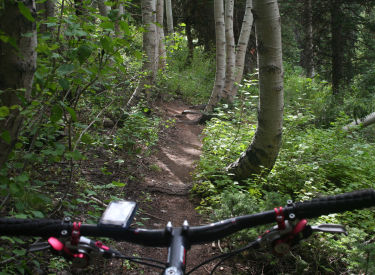
A shady glen on Gravedigger, about 12
miles into the ride. Photos and track from a ride on September 15, 2011.
|
| The ride as I've outlined it here is 13.6 miles with around
3000 vertical feet of climbing. Base altitude is 7350, top altitude is
8900 feet. Some navigation skill will be required, as there are a couple
of spots where you can go wrong and get lost. Don't ride without a good
current map, and it's very helpful to follow a GPS track file.
The dirt road from Daly Canyon, 1/2
mile into the ride. We're about 100 yards from the top, where the road
will swing right, and we'll find Tour des Suds on our right.
|

|
 |
There are some variations on this ride, especially in how
you begin. For example, you can start from Deer Valley and take the
Rossi
Hill trail around to SR 224, connect up to Prospect and take Prospect or
Ontario Ridge over to the Daly Canyon Road just before the turnoff to Tour
des Suds.
If you're starting from Park City Mountain Resort, take Lowell Ave, jog
down to King Road, then catch Gina's Bypass to Daly. (See my multi-track
area file.)
Climbing uphill on Tour des Suds. |
| A common variation is to catch Ontario Ridge shortly after
starting up Daly Canyon, so you're on singletrack within 0.2 miles.
Some riders prefer to climb on Team Big Bear rather than upper Tour des
Suds. OK. But don't climb up the DH trail from Ruby Lift to Empire (it
starts right where Tour des Suds forks off the Midmountain
Trail).
Exiting Tour des Suds onto dirt road,
about mile 4.
|

|
 |
OK, lets get to the Classic TG Loop.
There's a bit of roadside parking in Daly Canyon (at the continuation
of Park Avenue), right where the pavement turns to dirt. Start uphill
heading southwest. 0.2 miles later, you'll pass the entry to Ontario
Ridge, which is a common ride variation. Keep straight and climb up to the
water tank. Veer left around the tank. As you reach the upper level road
(mile 0.6), keep straight heading northeast.
View north from Moose Bones. We're
heading west, near the highest altitude of the ride. |
| As you reach a sharp right turn at the top of the road at
mile 0.9, turn right onto Tour des Suds. Stay on the main trail, which
will be the most level of any option. There are a LOT of sucker trails
forking every which-way.
The Moose Bones Trail, at the spot
where the DH from Ruby joins then forks away downhill.
|

|
 |
When you hit mile 1.4, note a trail on the left from SR 224,
coming up toward you. That's your landmark that it's time to turn sharply
right uphill. Go about 100 yards up, then fork hard left onto Tour des
Suds. (There's usually a sign there. Straight ahead is Empire Link. The
right fork takes you back down to TDS.)
TG is a fun trail, undulating and
twisting through the forest. We're just a little downhill from the SR 224
start of TG. |
| The trail will be fairly straight and simple for a while.
When you reach paved SR 224 at mile 1.9, go uphill 100 feet and cross to
the opposite side.
Navigate a series of jumbled interconnected eroded switchbacks, and
somehow get to the top of the sloped meadow to the trees. Find the
continuing TDS heading south.
TG will have some short climbs, and a
few spots that will be tricky for intermediate riders.
|
|
 |
After a series of switchbacks, TDS will arrive at the
Midmountain Trail. You're at mile 2.2. Fork right.
Keep left on Midmountain at a fork at mile 2.4.
Keep straight, level and right as Team Big Bear forks uphill at mile
2.8. Then keep left and level as a trail drops down to a ski lift at SR
224.
Critical spot! Fork
hard left to climb the dirt road. |
| At mile 3.0, fork left uphill on Tour des Suds. Two trails
join here. The leftmost is a downhill from Ruby Lift. You want the one to
the right. (The Midmountain continues straight here -- it will cross SR
224 about 100 yards later.)
Climb up TDS until you hit a broad dirt road at mile 3.8. Fork left.
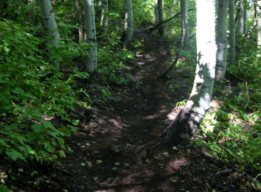
Pass the downhill from Ruby Lift as it crosses at 4.1.
Spot where you'll exit the maze of
dirt roads to take singletrack continuation of TG (sometimes still called
TG2 by geezer riders).
|

|
 |
When you hit a 90-degree left turn in the road (mile 4.2),
find the Moose Bones trail at the apex of the turn. It's the right-most
trail. Your direction will be west.
View east at the Empire Canyon Lodge
as we traverse ski slopes northbound on TG. |
| Climb Moose Bones. Keep straight and uphill as the Ruby DH
crosses at mile 4.5, and as a connector from Ruby joins a little later
(4.7).
When you hit paved road at mile 5.0, cross to continuing singletrack.
This second section of TG is more
technical. Because so many riders get lost at the dirt road, the trail is
narrower and feels more remote.
|

|
 |
At the next road 100 yards later, coast downhill to the next
hairpin turn (mile 5.2). The TG trail is the singletrack that drops
downhill from the turn in SR 224. (The doubletrack to the left of the
singletrack goes to the top of the ridge, where it connects to an
alternate singletrack. That singletrack will reconnect into TG.)
A fun series of stair-step root drops
on TG. |
| Keep right at the fork at the bottom of the initial plunge
onto TG. (left connects to the upper singletrack).
Cruise on TG for about 1/3 mile then keep left uphill at the trail fork
at mile 5.5. (Right is smoother and more level, and will reconnect 1/2
mile later.)
Keep level and right at a second trail fork at 5.6 (the trail on the
left also descends from the upper trail.)
Another little section of TG that may
challenge intermediate riders.
|

|
 |
At mile 5.8, keep left and uphill as the alternate trail
rejoins and forks away again. (The smoother trail on the right descends
back to Midmountain at the Empire Canyon Lodge.)
At 6.1, cross a doubletrack to continue on singletrack.
The fork where we turn off Midmountain
(we came from the trail on the right of the photo), and onto Link (the
trail on the left side of the photo). |
| At 6.3, you're at a CRITICAL SPOT where many riders
get lost. (There were zero trail indicators in 2011.) See the photos
above.
The trail comes onto dirt road, and the obvious line looks like you
should continue straight and downhill on the road. Instead fork hard
left uphill on the dirt road.
Another 180 turn. We're standing on
Little Chief. Uphill is the end of Link. To the right downhill is Johns99.
|

|
 |
As you reach the mine tailings, turn right on dirt road. At
the next road (mile 6.5) fork right downhill. At the next fork (mile 6.6),
keep left uphill on dirt road. Now watch for singletrack on your right
about 100 yards further, crossing a meadow to the trees (again, see photo
above). This used to be called TG2.
Twisty aspen-slalom on Johns99. |
| The TG trail now gets more technical. There will be roots
and narrow twisting trail. At mile 7.3, Black Forest joins on your left.
You may not notice, because it's not exactly a highway. TG then veers
right downhill and will hit Midmountain at mile 7.6.
Johns99 becomes dryer and narrower as
it hugs steep hillsides in scrub oak. |

|
 |
Turn left on Midmountain. (The plunging route straight ahead
as you drop down from TG is a cheater route. It will join Link lower on
the mountain. It's ugly, and I don't think it's legal.) Pedal west on
Midmountain for 0.1 miles. Then make a hard right turn (a virtual 180)
downhill onto Link.
Johns99 breaks out into a little
meadow near King Road. |
| Drop downhill on Link through thick conifers to mile 8.0. At
the signed trail fork, turn hard left onto Johns99. (Straight ahead takes
you onto Little Chief.)
We're now on Johns Trail. Aspen roots
and aspen trunks to hop over. Leaning trees to dodge. |
|
 |
At mile 8.6, Empire Link joins on your right and will cross
over. Take the right fork to stay on Johns99. Johns99 changes from thick
tall aspen forest to a dryer mix of low aspen, maple, and scrub. You'll
cross a few small meadows with breakout views.
At mile 9.4, you'll hit gravel King Road. Drop downhill a few feet and
find continuing Johns99 on the opposite side. After riding aspen for a
bit, the trail enters dark fir forest.
Lower on Johns Trail, the aspens are
mixed with maple. We're almost to the 4:20 trail fork. |
| When Johns99 reaches the Silver King Mine, hold to the right
and climb up to the ridge by the ski lift. At mile 10.0, keep to the right
of the lift and begin climbing a broad rocky trail. Johns Trail will veer
to the right off of this broad path near the top, at mile 10.1.
Here's the beginning of 4:20.
|

|
 |
Descend Johns Trail. This is twisty and fun, with plenty of
aspens to dodge and roots to navigate. But it's not everybody's cup of
tea. I love Johns precisely because it's a tricky slow downhill. Other
riders hate it because it's a tricky slow dowhill.
When you reach the 4:20 sign at mile 11.5, fork left. A cheater route
will join you on your left. Keep straight and head south.
Cruising gently downhill on 4:20. Lots
of aspen forest mixed with maples.
|
| After dropping through a series of tight turns, the 4:20
trail heads south a bit more. The riding is in aspens with a thick
understory of shrubbery.
4:20 drops abruptly onto King Road at mile 11.9. Find Gravedigger a few
feet down the road, on the downhill side.
Hairpin turn on 4:20. Quite a few of
these. Fun!
|

|
 |
Gravedigger is cooler, in deep aspen and fir forest. The
surface is a little more technical, with some roots and rocks.
At mile 12.1, Gravedigger hits an ugly rough rocky doubletrack. Head
right, uphill. About 50 yards later, fork left on singletrack. Descend and
cross the creek into the trees.
Descend from 4:20 to King Road. Roll
over a big rock, then drop quickly. |
| At 12.3, fork right uphill. (Straight ahead is the OLD
Gravedigger. It's ugly-tech, and has now been designated as the
continuation of the Moosehouse Trail. But it rejoins shortly, if you want
to try it.)
Gravedigger drops off King Road a few
feet downhill from 4:20.
|

|
 |
At 12.5, keep straight as Moosehouse crosses. Gravedigger
now heads straight south, hugging a fairly steep mountain side. The
trailside flora changes from aspen to maple, then scrub oak.
Gravedigger changes from rooty aspen
forest to fir. |
| At 12.9, skirt the fence and join doubletrack. Keep
generally left and coast downhill. The dirt road will do a 180. Just
before the road splits (above the water tank), veer left onto singletrack
(mile 13.1) that crosses to the other side of the gulch.
Ugly and loose, but mercifully short.
Here's where you fork uphill on Gravedigger.
|

|
 |
This singletrack uses some old mine fixtures as playthings.
There are cheater routes around a couple of trickier stunts. Keep heading
downhill. The singletrack trail will rejoin the downhill road shortly.
After a short rocky climb (versus
hike-a-bike), Gravedigger drops off the loose doubletrack to cross the
creek. |
| If you skipped the singletrack, veer left downhill at the
road fork. Go around the water tank as you do another 180.
Coast back to the parking spot on the dirt road. Wow.
Heading south on the last section of
Gravedigger.
|

|
 |
Bottom line: This is an epic ride that requires good
navigation skills and a map. Or a GPS unit with track display. Or somebody
who's done it before -- and done it recently, because the area trails are
constantly changing. Just in 2011, SIX new trail forks were added to this
route.
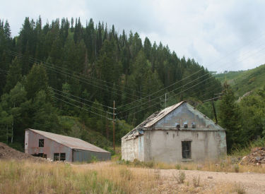
Abandoned mine buildings at the bottom
of Gravedigger. |
Riding guide, clockwise loop:
0.0 Uphill on DT N40 37.960 W111 29.846
0.6 L around water tank, then straight
N40 37.643 W111 30.140
0.9 R onto Tour des Suds N40 37.786 W111 29.814
1.4 Hard R uphill N40 37.547 W111 29.925
1.5 L, continue TDS N40 37.594 W111 29.936
1.9 R on paved road, then L uphill
N40 37.259 W111 29.729
2.2 R on Midmountain N40 37.141 W111 29.752
2.4 Keep L N40 37.184 W111 29.848
2.8 Keep level (Team Big Bear crossing)
N40 37.113 W111 30.151
3.0 L uphill on Tour des Suds
N40 37.019 W111 30.414
3.8 L on dirt road N40 36.670 W111 30.388
4.2 R on Moose Bones N40 36.850 W111 30.024
4.5 Ruby crosses, keep straight
N40 36.769 W111 30.093
5.0 Cross paved road N40 36.471 W111 30.382
5.1 Downhill on road N40 36.441 W111 30.428
5.2 Straight into ST as road turns
N40 36.428 W111 30.474
Keep R at next fork N40 36.436 W111 30.488
5.5 Keep L uphill N40 36.571 W111 30.642
5.6 Keep straight (R) N40 36.671 W111 30.657
5.8 Keep L uphill N40 36.645 W111 30.880
6.1 Cross DT N40 36.743 W111 31.058
6.3 Hard L uphill on DT Critical!
N40 36.804 W111 30.978 |
6.5 Fork R downhill on DT
N40 36.836 W111 31.020
6.6 Fork L uphill on DT N40 36.902 W111 30.942
6.7 R on ST N40 36.934 W111 30.965
7.3 Keep straight (Black Forest on L)
N40 37.371 W111 31.030
7.6 L on Midmountain N40 37.516 W111 30.933
7.7 Hard R on Link N40 37.496 W111 30.994
8.0 Hard L onto Johns99 N40 37.356 W111 30.802
8.6 R to stay on Johns99 N40 37.580 W111 30.854
9.4 Cross King Road downhill
N40 37.831 W111 30.321
10.0 R up to ridge, go R of ski lift
N40 37.952 W111 30.727
Up on rock DT
10.1 R onto Johns N40 37.974 W111 30.659
11.5 R onto 4:20 N40 38.411 W111 30.201
11.9 Cross King Road downhill to Gravedigger
N40 38.184 W111 30.093
12.1 R uphill on rocky DT N40 38.026 W111 30.079
After 150 feet, L on ST
12.3 Hard R N40 37.958 W111 30.060
12.5 Straight as Moosehouse crosses
N40 37.950 W111 30.009
12.9 Join DT, veer left N40 37.617 W111 30.251
13.1 L onto ST N40 37.595 W111 30.196
13.2 Rejoin DT N40 37.719 W111 30.115
13.6 At parking |
Getting there:
As you drive into Park City, you'll arrive at the "main"
intersection of Park Avenue and Kearns Blvd. From the light, head
south on Park Avenue (straight ahead if you came from I-80, a left
turn if you arrived on Kearns Blvd from US-40). Keep going through town.
Just after the road veers a little to the right, it becomes narrower. As
you reach the end of the homes and pavement, find parking on your left
along the creek. Start the ride by continuing up the dirt road the
direction you were driving.
Riding resources:
Single-page riding guide
Track files (right click and "Save as..."):
TG Loop riding
track as described
Area trails including
loop (over 70 tracks)
Print topo map: View
Lodging, camping, shops:
Links to Park City area resources

|

|
|


