 |
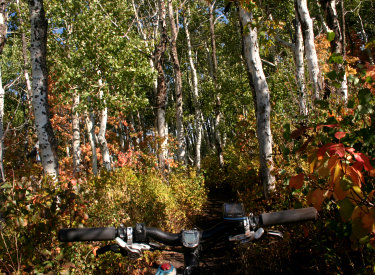
Jenni's Trail Jenni's Trail
extends from the Park City Mountain Resort (PCMR) northern parking lot to
the top of the Payday Lift. The trail is new in 2012. It's 5.1 miles in
length, rising 1300 vertical feet from 6900 to 8200 feet elevation. View
north along Jenni's Trail as the maples turn red in the September
sunshine. Photos and trail description by Bruce based on a ride on
September 19, 2012. |
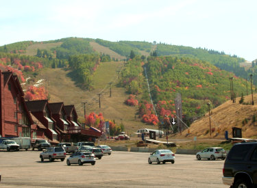
| The most obvious ride for many Park City visitors will be
sitting on the chairlift uphill then coasting down Jenni's Trail on your
bike. (As of 2013, the lower 1.2 miles of singletrack is climbing-only.
You'll need to make the final descent on Crescent Mine
Grade, which ends
right across from Jenni.) But for most of us, what Jenni's gives is a nice climbing route from
PCMR to the higher mountain. The Steps Trail, Midmountain,
Johns, and
Johns99 are right there.
View southwest in the northern PCMR
parking lot, right where everybody parks to ride Spiro. The arrow points
to the starting point of Jenni's Trail.
|
|
 |
The trail base is wide and smooth. Most of it -- about 95% -- is suitable
for experienced beginners. But the section that follows the old narrow
singletrack from Loose Moose to the tailings (old PC riders know where
this is) is steeper and has a couple of tricky spots that beginners and
early-intermediates will hike.
We're looking back, so I can show the
start of the trail. Note the trellis and the paved trail turning to dirt
(the paved part turns and heads uphill along the fence). |
| The trail sends a short connector to the midpoint of the
lift at the top of the Alpine Slide. This is a good turn-around point for
beginners riding up-and-back.
Heading across the lower beginner ski
slope as we begin our adventure.
|

|
 |
Jenni's makes a nice uphill for some short but satisfying
loop rides. There's the obvious northbound loop via Midmountain to descend
Spiro and connect back to the trailhead via Silver Spur. This ride is 11.6
miles.
There are many different loop options southbound via Johns, Johns99, or
Midmountain. Note that using Johns Trail turns the ride into advanced
technical.
Maples mix with aspens as we climb
higher on the mountain. |
| I love any excuse to descend Johns Trail. But the multiple
connections back to Jenni's are confusing and not well marked. Your
options (top to bottom) are Loose Moose, Billy's Bypass, and Flat Cable.
Chances are, you'll simply blunder your way back from Johns by trying any
trail heading west around the mountain. If you have a specific
route in mind, use a GPS track or go with an experienced PC rider.
Looking southwest. You can see the
continuing trail on the ski slope in the middle of the photo. The climbing
rate is easy.
|

|
 |
First, the hardest part. Finding the bottom of the trail.
From the parking lot, look southwest at the notch between the condos
and the little hill. (See 2nd photo above.) The trail will start just
before and to the right of the ski lift. See the little trellis/scaffold thingy? That's where the trail starts. (2012. Things
change.)
The trail goes in and out of aspen
groves as it crosses ski slopes. |
| Get on the gravel road heading toward the ski lift. The
first singletrack you pass is Silver Spur on your right. Don't turn uphill
yet. Keep going until you hit the pavement by the trellis. Now fork hard
right up the paved trail. As the trail turns left, keep going straight
onto dirt singletrack. You're on Jenni's.
Higher on the mountain, fir forest
mixes in with aspen and maple.
|

|
 |
A quarter-mile later, you'll cross a gravel lift road. At mile 1.4, you'll cross
the Cresent Mine Grade (CMG) singletrack. Keep straight and uphill.
The next navigation hazard is at mile 2.7 near the top of the Alpine
Slide. Loose Moose, Billy's Bypass, Flat Cable, and the ski lift connector
trail get tangled up here. Take your first opportunity to turn hard right
uphill. There's a trail sign at the intersection, but the direction to
ride may not be obvious.
At mile 3.4, keep straight as a faint ST (Loose Moose) comes in from
the left.
Skier's-eye view from the trail as we
look north. |
Options! At mile 4.7, the trail hits a broad
gravel ridge where multiple dirt roads intersect. From right to left:
1. Right uphill and RIGHT of the little building takes you to Steps or
Midmountain.
2. Right uphill and LEFT of the building takes you to Midmountain.
3. Straight ahead then downhill takes you toward the Silver King Mine and
Johns 99.
4. Veering slightly left, then up doubletrack on the right side of the hill
takes you directly to Johns.
5. Across Drift Road to the singletrack -- 90 degrees to your left -- is the
continuing final portion of Jenni's. |

|
 |
Let's assume you want to ride the loop via Johns, but want
to finish Jenni's first. Turn left to cross Drift Road. Aim for the
singletrack. It's just to the left of the road heading eastbound up the ridge
-- the access road to the top of Payday, which you'll join in
another 1/4 mile. Again! Any ride descending
Johns must be considered expert or advanced-intermediate level.
At the top of Jenni's singletrack, turn left on the lift road and head
uphill 100 yards to the top of the Payday lift. Veer right and turn almost
180 degrees. Spot the broad trail just to the right of the small building.
Coast downhill about 200 feet, then turn hard left onto Johns singletrack
(mile 5.2).
John's Trail. This expert loop is a
twisting aspen-dodging adventure. Beginners and less-daring intermediates
should opt for the Midmountain to Spiro loop. |
| As you descend Johns, the first fork is at mile 6.3. Turn right. (Left takes you to the ski slope and the faint Trestle Trail.)
Two turns later, the next fork at mile 6.5 is the 4:20 Trail. Go left.
One more turn, and you'll hit a fork on a flat old road-grade at mile 6.6.
This is your first loop option. Fork left. As you come out onto the ridge
near Drift Road, keep right and flat at the singletrack trail fork. Follow
Loose Moose westbound until it dumps you onto Jenni's. Turn right and head
downhill toward home.
Handlebar view as we twist down Johns.
Tight squeezes, tight turns, and roots rooots roooots.
|
|
 |
Next option: On the old road-grade at mile 6.6, go right.
Then turn 90 degrees left to continue downhill on Johns (straight ahead will
connect you to 4:20). At mile 6.8, fork left on another old flat
road-grade. You're now on Sweeney's. Keep straight past the uphill
connector to Sweeney's last gasp. As you approach a narrow open ski lane, keep straight ahead and traverse
around the ridge. (You've just left Sweeney's, which turned hard right downhill
here.)
An easier turn on Johns. |
| Descend the turns of Billy's Bypass (or upper Flat Cable,
depending on who you ask). When you approach the clump of aspens above the
Alpine Slide, keep straight-ish until you blunder onto Jenni's in the
aspens. Now fork hard right downhill (straight ahead goes back up the
hill!). Make the 180 left turn at the fork with the lift connector trail,
and head downhill. Remember to turn hard right onto Crescent Mine Grade at
the cross-over -- Lower Jenni's is climbing-only.
Best option for intermediates and
advanced beginners: Head north on Midmountain. See the description below.
|

|
 |
Another option: Instead of forking off Sweeney's as per
option two above, continue downhill on north Sweeney's to the Flat Cable
fork (also on a flattish old road-grade). Keep left and uphill on Flat
Cable. You'll climb through a few turns along the Alpine Slide until you
join Billy's Bypass near the aspen clump as described above.
In a maple grove at the bottom of
Spiro, where Silver Spur will take us back to the resort parking. |
| Option for intermediates: Jenni's to Spiro Loop, 11.5
miles
Ride up to the saddle at mile 4.7 as described above. Turn right, and
go on the right side of the little building. Climb uphill on a broad trail.
Keep straight past the southbound Midmountain Trail on your left. Fork
right on northbound Midmountain at mile 4.9.
Stay on Midmountain to mile 7.8, then fork right downhill on Spiro.
Stay on Spiro past Ham and Eagle. As you near the bottom, fork right on Silver Spur at mile 10.8. Cross the lift road. When you
reach the resort, turn left downhill and head for the parking area.
|

|
Ride description, Jenni's lariat loop with
John's:
0.0 Wire gate north of condos, west uphill
0.06 Pass Silver Spur, keep straight
N40 39.095 W111 30.528
0.1 Hard R uphill, paved trail
N40 39.043 W111 30.524
Keep straight onto dirt
trail
0.3 Cross lift road N40 38.990 W111 30.656
1.4 Straight (R) to cross CMG
N40 38.639 W111 30.887
2.7 Fork hard R to stay on Jenni's
N40 38.567 W111 30.474
(straight = to lift or to
Flat Cable)
3.4 Keep straight (L = Loose Moose)
N40 38.378 W111 30.434
4.7 Veer L, cross DT to ST
N40 37.956 W111 30.727
5.0 L on DT N40 38.058 W111 30.577 |
5.1 R 150 degrees at
lift
N40 38.090 W111 30.514
go R of building
5.2 Hard L on Johns N40 38.019 W111 30.566
6.3 Fork R (L = to Trestle) N40 38.345 W111 30.242
6.5 Fork L (R = 4:20) N40 38.411 W111 30.200
6.6 Fork L (R = continue Johns)
N40 38.436 W111 30.206
6.7 Keep straight (hard L = Sweeney's)
N40 38.494 W111 30.309
6.8 Keep R and level N40 38.446 W111 30.359
6.9 R and downhill on Jenni's
N40 38.378 W111 30.434
7.5 Keep L, then hard L
N40 38.567 W111 30.474
(straight = to
lift)
8.8 Hard R onto CMG
N40 38.639 W111 30.887
10.2 Back at parking |
 |
Getting there: In Park City, follow the signs to Park City
Mountain Resort. As you see the first parking area, turn in and park
there. Look to the southwest (toward the main resort. Pedal toward the
spot where the parking lot meets the condos. As you reach a wire gate, the
gravel doubletrack that heads uphill toward the Alpine Slide is the
beginning of our ride. |
|


