 |
Aqueduct Trail
with Gasline, Hidden Valley,
and side-trails
For years, I considered the wide, flat, ugly Aqueduct trail to be
unworthy of mention. Yeah, I raced on pieces of it every year but tried to
stay off it at other times. But now, new trail construction may have you
deciding that it's worth putting tires on this doubletrack.
For riders in Sandy and further north, the addition of Hidden Valley
makes Aqueduct a dirt arrow from city streets straight to the heart of
Corner Canyon's trail system.
View south on Aqueduct. Photos and ride review by
Bruce on September 28, 2016.
|
| If you consider the Gasline trail to be a southbound continuation
of Aqueduct, and add Hidden Valley to the north end, it's a continuous
3.6-mile route. Hidden
Valley takes you to the north end of the Sandy section of the Bonneville
Shoreline Trail (BST). And at the south end, Gasline delivers you to Ghost
Falls.
Along the way from Gasline to Hidden Valley, Aqueduct has
connections to the Carolina Hills Connector, the BST, Quail trail, Sadler
trails (uphill and down), the Corner Canyon Road, the Orson Smith trail,
and Ralph's Trail. That's a lot of ride variations. I'll discuss these
connecting trails as we move along.
Looking north in the area near the Quail Trail. |

|
 |
Gasline Trail...
At the southern end of this hillside corridor, Gasline is 0.5 miles in
length. It joins southern end of the Aqueduct doubletrack to the Ghost
Falls trail near its origin on
the Canyon Hollow doubletrack. From here, you can crank uphill to Ghost
Falls and on to Jacob's Ladder. Gasline is an easy cruiser
trail.
Like Aqueduct, Rattler, and the Corner
Canyon BST, Gasline is NEVER closed due to weather.
Gasline trail. Oak and maple. Useful connection from
the BST to Ghost Falls.
|
| The north end of Gasline meets the south end of Aqueduct at a somewhat-confusing
intersection, made worse by pipeline-construction digging in recent years.
Looking north at the broad doubletrack, the westbound BST singletrack is behind you
to the left and downhill. (The BST joins Aqueduct for a short distance
here.) 90 degrees to the left is the doubletrack dropping down
to the Carolina Hills trailhead and the Corner Canyon trail.
Looking southwest at the entry to Gasline from
Aqueduct.
|

|
 |
Aqueduct...
As you pedal north on the Aqueduct doubletrack, the Corner
Canyon Bonneville Shoreline Trail (BST) forks to the
right uphill after 100 yards. This trail would take you up to Rattler and
to the BST trailhead on the Corner Canyon Road.
See the Corner Canyon overview page for
more information on local trail options. Note that Aqueduct is NEVER
closed due to weather conditions. See the Corner
Canyon trail closure page for status of other nearby trails in winter
or after storms.
Looking north on Aqueduct from Gasline, as Little
Rocky waits on a trail post. |
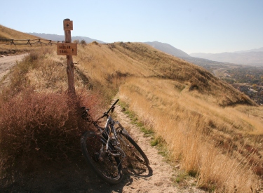
| 0.6 miles from the start of Aqueduct, the Quail trail forks
to the right uphill. This trail is 0.3 miles long, climbing north to end
on the Corner Canyon gravel road. Like Aqueduct, Quail is a nice sandy
rainy-day trail that's hard to damage.
Another day, another bike. The superfly sits at the
Aqueduct fork for the Quail Trail. |

|
 |
At mile 0.9 of Aqueduct, the Sadler trail forks right
uphill, reaching the CC road in 0.2 miles. 1/10th mile later is the second
(downhill) half of the Sadler trail on your left. It drops 0.3 miles to a residential road. Chances are, neither Sadler trail will be of much
interest to you. The lower Sadler to upper Sadler route is basically a
path to take local neighborhood cyclists up to the Corner Canyon Road.
At 1.3 miles, Aqueduct crosses the Corner Canyon Road. Turning downhill
here would take you 0.3 miles to the Orson Smith trailhead parking.
Looking southwest as Sadler leaves the Corner Canyon
Road. |
| After crossing the road, pedal 0.3 miles, and the Orson Smith
trail will cross the road. The lower part descends 0.3 miles to the
trailhead on Highland Drive. The upper trail is 0.5 miles of 10% grade as it climbs to the
Draper to Sandy BST section south of Bear Canyon. The first bit of
Orson Smith above Aqueduct is not only ugly-steep, it's
ugly-loose too. But people do ride up, usually to do a little loop across
the Bear Canyon bridge on the BST, which is kind of cool. You can drop
back to Aqueduct on Ralph's.
Bogged down and powered out. A little ways up Orson
Smith from Aqueduct, and I'm not riding. So it's a good time to stop and
take a picture. |

|
 |
Another 0.4 miles north on Aqueduct, Ralph's trail forks right
uphill. It's 0.4 miles of 10% pitch to the
BST north of the Bear Canyon
bridge. On your left about 30 feet later is a seldom-used and steep
continuation of Ralph's that drops to a neighborhood cul-de-sac.
In the Ralph's trail area, we're looking southwest on
Aqueduct.
|
| Hidden Valley...
At 2.5 miles from Gasline, Aqueduct ends. The route continues on
singletrack veering slightly to the right. The Hidden Valley singletrack
extends 0.6 miles further north to the Hidden Valley Park. Here it will
end on a paved trail loop that also connects to the BST.
Note that Hidden Valley, and the Sandy BST above it, may be closed when
the trails are wet.
Aqueduct drops undergound. And Hidden Valley begins.
Looking north.
|

|
 |
This trail is new in
2016, opening new loop options through its connection to Aqueduct on the
south end and the BST on the north.
There's a bit of gentle up-and-down
riding but little overall elevation change. The Hidden Valley singletrack
is a fun ribbon
of undulating dirt beneath a canopy of maple and oak.
Cruising through maple forest. |
| There's a fork shortly after crossing the Little Willow
Creek bridge northbound. Keep to the right for the trailhead on the paved park trail.
(
The trail to the left ends on the cindered doubletrack that climbs
the canyon.) Cross the gravel Little Willow Creek road.
Looking back to the south as newly-dug trail crosses
a little clearing.
|

|
 |
Hidden Valley ends on the south end of a paved trail loop in Hidden
Valley Park. To get to the BST, go 100 yards north (to your right) on the
paved trail to catch the BST Connector. To climb to the upper BST
trail,
continue another 50 feet and turn right on the doubletrack.
Bridge over Little Willow Creek, looking south.
|
Riding notes, loop from Corner Canyon Road
BST TH
and returning via Aqueduct and CC BST:
0.0 Uphill side of road, north on ST
N40 30.363 W111 50.078
1.0 Keep R (L = Orson Smith connector)
N40 31.156 W111 49.824
1.1 Keep R (L = Orson Smith)
N40 31.254 W111 49.765
1.4 Cross Bear Canyon bridge
1.5 Keep R (L = Ralph's)
N40 31.475 W111 49.569
2.6 Little Willow Creek road
Cross to upper trail N40 32.117 W111 48.836
(option lower trail a few feet
down road)
3.0 Gate, L downhill on DT
N40 32.371 W111 48.579
3.1 L on paved trail N40 32.329 W111 48.716
(Pass BST connector trail in
100 ft) |
3.3 L on Hidden Valley ST
N40 32.232 W111 48.837
3.9 Join Aqueduct
N40 31.894 W111 49.306
4.4 Straight (L = Ralph's)
N40 31.596 W111 49.668
4.8 Straight (Orson Smith crosses)
N40 31.314 W111 49.903
5.1 Cross Corner Canyon Road
5.5 Pass Sadler trails N40 30.803 W111 50.234
5.8 Pass Quail ST (on L)
N40 30.428 W111 50.261
6.3 L uphill on BST N40 30.063 W111 50.173
6.6 Keep L (R = Rattler)
N40 30.176 W111 50.076
6.8 Back at trailhead |
 |
Getting there, northern (Sandy) trailhead:
Take
Wasatch Blvd to Hidden Valley Park, about two miles south of Little Cottonwood Canyon on the east
side of the road. (From I-15, take the 90th South exit, which will turn into 94th south as
it approaches the mountains. At the mouth of Little Cottonwood, turn right on
Wasatch.) The
park is located on a curve in the road just past a large church on your left. From the
parking area, bike towards the mountain on the paved path. After 100 yards, you should see
a "Bonneville Shoreline Trail" sign pointing uphill. This connects
via a steep doubletrack to the upper trail. For the lower connector, go
further on the paved trail and turn left on singletrack after about 100
feet. (For a loop ride, the Hidden Valley singletrack is another 800 feet
south on the paved trail.)
Orson Smith Park: From Draper, take 123rd South to 13th
East and turn south (right). At the roundabout just down the hill, turn east
(the equivalent of a left turn at the roundabout) on Pioneer
Road. Go around one mile to 20th East, then turn right going south on
Highland Drive. Turn left to the parking lot of Orson Smith Park. Reach
the Aqueduct trail by pedaling up the Corner
Canyon Road 0.3 miles, or 0.3 miles via the singletrack Orson Smith trail.
Bonneville Shoreline TH on Corner Canyon Road: Go to Orson Smith Park as
above, but
immediately turn right as you enter the parking area. Drive on the gravel
Corner Canyon Road 1.1 miles uphill. Turn right into the BST trailhead.
Take the BST southbound down to the junction of Gasline with Aqueduct.
Bathrooms and water at these trailheads.
|
From Corner Canyon (Equestrian Center) Trailhead:
On Highland Blvd. Climb the Corner Canyon
singletrack,
joining doubletrack on the way, to a wide intersection of multiple trails.
The BST is across the wooden bridge 90 degrees to your left. Climb up
to Aqueduct 0.3 miles.
Coyote Hollow trailhead: From Traverse Ridge Road,
turn to Mike Weir Drive. Drive about a mile until the road veers left downhill. Take the next right
turn, turn right again, then left. You should now be on Gray Fox Drive.
Take the next right into Coyote Hollow Court. The parking is on the right
at the end of the pavement. After entering singletrack, keep left until
you find yourself descending on doubletrack. As you reach an intersection,
the BST is straight ahead. Keep heading northeast and downhill until you
reach the bridge, then climb the BST to Aqueduct. See the Corner
Canyon BST page. |
|


