Ghost
Falls lies in Draper's Corner Canyon riding
area. It was one of the first mountain bike routes in the canyon and
is still a good ride. I love it. But there are newer and somewhat easier trails that run parallel to Ghost Falls and connect to it. So most riders
do only pieces of the Ghost Falls trail, rather than riding the whole
thing. This page will attempt to explain some of those connections and
routes.
The spring-fed creek breaks into Ghost Falls
on this limestone outcrop just off the Ghost Falls trail. (You need to get
off your bike and hike about 70 feet to see this.) Original review by Bruce
Argyle in 2003, latest update May 15, 2017.
Ghost Falls has a trailhead at its upper end on the Corner Canyon Road. But everybody,
well almost everybody, pedals some other trail to reach Ghost Falls.
The Ghost
Falls trail itself is 1.6 miles in length, running from the Canyon
Hollow doubletrack (where it shares a bit of common trail with Gasline)
to the Ghost Falls trailhead on the Corner Canyon Road. It rises 700
vertical feet to a top altitude of around 5750.
Heading toward the trail (between the outhouse and
the kiosk) after turning off the Corner Canyon road.
The most-used sections of the trail are intermediate in technical
requirement. The section between the lower Canyon
Hollow interconnector (mile 0.4 when climbing uphill) and the Rattler
trail fork (just downhill from Ghost Falls itself) is upper-intermediate in tech
requirement, with some big embedded boulders. Intermediates can walk a couple of
ugly spots, which are short.
In November 2016, even the
smoother areas in the trees were tougher here, with trenching of the trail and
stiff (up to 15% grade) climbing. Most riders were bypassing this
segment by riding Rattler to the falls instead of climbing lower Ghost Falls. In
May 2017, the trail had been buffed up and was smoother to ride. In other
words, conditions may vary.
Derek and Mike climb away from the
falls on the upper Ghost Falls
trail, heading towards Jacobs Ladder. This section between the falls and
the Ghost Falls trailhead is the most popular piece of the trail. Photo September 25, 2008.
The trail is a mix of exposed sandy rocky slope on the lower mountain and
shaded dirt higher up. The upper trail (above Ghost Falls) is plush riding in relatively cool maple and oak forest.
Approaching a bridge while riding downhill on upper
Ghost Falls in November 2016.
There are multiple trails in the area that connect to the Ghost Falls trail. If you don't know the "lay of the land"
it can be awfully confusing. So if you're not prepared to
have a little exploring adventure, go with somebody who's been there
before. Or download a GPS track and follow it.
View northwest toward Draper,
around the middle of the trail -- in the area just below Ghost Falls
itself.
Ghost Falls as an uphill
The bottom of the Ghost Falls trail shares a common origin with Gasline.
You can get to the south end of Gasline (and the bottom of Ghost Falls)
via the Canyon
Hollow doubletrack, or via Gasline itself. Ghost Falls begins on Gasline just before
Gasline's southern end at the doubletrack. See the map.
If you're on the southbound Corner Canyon Bonneville
Shoreline trail, take Gasline from the south end of Aqueduct
(at this point
Aqueduct is also the BST). You can also get to the
Aqueduct-BST-Gasline junction by climbing the eastbound BST from the
four-way intersection at the top of the Corner Canyon
trail.
On the Corner Canyon trail, heading uphill toward
Ghost Falls in May 2003.
To reach the trail from the Equestrian trailhead, keep straight on the doubletrack portion of
the Corner Canyon trail, crossing the BST to the doubletrack Canyon
Hollow. Continue southbound and uphill. Pass the singletrack
connector (on your right), staying on doubletrack until you reach a gate. Turn
left on a bridge across the creek on the combined Ghost Falls and Gasline trail
and veer back toward the north. Quickly fork to the right to begin climbing
Ghost Falls.
An alternate route is to fork left on the BST
at the top of the Corner Canyon doubletrack and climb
uphill to Aqueduct. Make a hard right turn on Gasline
when the BST joins Aqueduct and head south to the Ghost Falls trail.
Much of Ghost Falls is in tall maple forest..
From Coyote Hollow (or the eastbound BST), catch the Canyon
Hollow singletrack trail just east of the Coyote Hollow trailhead.
Pedal 0.6 miles uphill, then fork to the left downhill on the connector. As you
hit the doubletrack, keep right and uphill, then turn to the left at the gate
and cross the creek as above.
My Rocky Mountain Blizzard fatty has reached the
bridge that marks Ghost Falls. (We're facing south, climbing.) The falls
are 70 feet to the left. Just around the corner is the final Canyon Hollow
connector and the upper Ghost Falls trail.
If you continue riding uphill on Canyon Hollow, you'll hit another connector
to Ghost Falls 1.4 miles from Coyote Hollow (0.8 miles from the first
connector). After crossing the creek, fork right uphill to climb upper Ghost
Falls.
(To visit the falls before continuing, keep straight at the trail fork after crossing the
creek. Just after crossing the next bridge, the falls are to your right.)
On the upper Ghost Falls trail, looking west at the
connecting trail to Canyon Hollow.
But here's the thing...
As an uphill route, most riders do only the upper section of Ghost Falls,
from the falls to the trailhead on the Corner Canyon Road. There are two
options. (1) Take the BST to Rattler,
joining Ghost Falls just downhill from the falls, or (2) climb Canyon
Hollow to the upper connector to join Ghost Falls just
above the falls (as described above -- see the map).
Mitt heads up the canyon on Rattler. Probably 90% of
riders take Rattler to join the trail just below Ghost Falls, rather than
riding the lower Ghost Falls trail
itself.
Ghost Falls as a downhill
Many riders use Ghost Falls to continue downhill from Jacob's
Ladder. But regardless of how they got on Ghost Falls as their downhill
route, most riders transfer from Ghost Falls to Canyon
Hollow at the upper connector -- avoiding the technical and steep
rocky stuff -- then transfer to lower Rush about 0.2 miles
further downhill.
However, rock-loving tech riders will stay on Ghost Falls.
View east from Ann's trail across the canyon. The
Ghost Falls trailhead is on the Corner Canyon Road.
To descend Ghost Falls from the top, you'll need to be on the Corner Canyon
Road. From downhill, you can pedal or drive. (Rattler
has a connector that climbs up to the Corner Canyon Road. From the top of this connector to the trailhead is
about 0.9 miles.)
Looking northwest downhill at the gate just uphill
from the Ghost Falls trailhead. You can see the tire tracks where bikes
head across the road to jump on the trail.
From the Peak View trailhead (at the top of Ann's
and Clark's), descend the Corner Canyon Road 0.8 miles.
Just after riding around the metal gate above the Ghost Falls trailhead, veer
left onto singletrack. This trail will pass just below (and connect to) the
trailhead. A fun variation on this route is to take Brock's Point from the Peak
View trailhead, keep right on Canyon
Hollow, then take 1/4 mile of the Corner
Canyon Road down to the Ghost Falls trail. This will add about 0.2 miles and a
small bit of climbing.
Typical winding trail between the trailhead and the
falls. May 2017
Your first "bail" option is the connector just
south of (above) the falls, 0.7 miles downhill from the trailhead. A left
turn takes you across the bridge to Canyon Hollow. Fork right to continue
on Ghost Falls.
The next exit is just past the falls, mile 0.8, as Rattler forks right
uphill. In 2016, the 100 yards just past the Rattler fork is the most
technical part of Ghost Falls. It's more do-able downhill than as a climb.
Eyeball the slope and decide if you want to hit it. If so, take the left
downhill fork.
At mile 1.1, there's another fork to Canyon Hollow on the left, then a
fork to Rattler on the right.
A little trickle below the falls. Don't stop here --
the actual falls is uphill behind the box elder trees.
After the Rattler fork, you're on sandy trail that tends to
stay dry and warm. There's one kind-of-nasty rocky turn here.
When you hit Gasline at mile 1.5, go left if you're headed to Canyon
Hollow or right if you're taking Gasline over to the BST or Aqueduct.
Rocky turn on lower Ghost Falls. Intermediates can
easily walk the short techy sections, but overall it earns an
upper-intermediate to advanced
tech rating, depending on the balance between erosion and trail smoothing
work.
If the above video does not appear on your
browser/device, you can watch it on YouTube by clicking
here.
The Clarks - Ghost Falls Loop -- an old classic
This loop combines Corner Canyon, a bit of the BST, Clark's,
a bit of Ann's, a bit of the Corner Canyon Road, and Ghost Falls in a
lariat counter-clockwise loop.
After climbing Corner Canyon from
the Equestrian (Highland Drive) trailhead, veer right (west) on
the BST and head for Clark's
trail. At the Peak View trailhead, take the Corner Canyon Road (or the
Brocks-Canyon Hollow-Road combo) to the
upper end of the Ghost Falls trail and take it downhill to Gasline. Drop
the doubletrack back to the Corner Canyon trail. Veer onto Creekview for
the final descent. Altitude change by this route is 1200 feet, distance
6.7
miles.
On upper Clark's Trail in 2017 while riding a loop that includes Ghost Falls as the downhill.
Riding notes, Clarks Ghost loop from
Equestrian TH:
0.0 L uphill on ST as it exits tunnel
0.4 Keep generally L uphill
0.6 ST joins DT, continue uphill
0.9 Keep slightly R (L= east BST)
1.0 Veer R on DT at fork (BST)
1.2 Join Canyon Hollow, go R
1.2 Fork L uphill on BST+Clark's
1.4 Fork L across bridge (Clark's)
2.7 L on Ann's
2.9 Trailhead, northeast on Corner Canyon Road
3.7 L onto ST Ghost Falls after gate
4.5 Fork R (L=to Canyon Hollow)
4.6 L (R=Rattler)
4.8 Keep R (L = to Canyon Hollow)
5.2 L on Gasline, cross Bridge
R downhill on DT
5.5 Keep straight onto Corner Canyon
5.6 Veer L on Creekview Connector
6.7 Back at tunnel
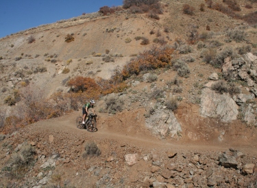
Bruce
pops out of the tall maple forest into scrub oak in this May 2017 drone
shot.
Map updated June 2019
Getting there (Highland Drive Equestrian Center trailhead): Take the Bluffdale exit from I-15 and turn
east towards the mountains. Continue on Highland Drive until you reach the
ballpark parking lot. Directly across the street from the parking, the Lower Corner Canyon
trail heads uphill (GPS N 40° 30.351' W 111° 50.721'). To
reach the trailhead from the north (Sandy area), take 13th East southward until it ends at
the stop sign just past the underpass. Turn left and drive 1/4 mile.
Coyote Hollow trailhead: Take the Bluffdale exit from I-15 and turn
east towards the mountains. Climb the hill as above, but turn right at the
light on Traverse Mountain Road. After one mile, turn into Mike Weir Drive
on your left. Pass the Mike Weir trailhead 1/2 mile later and continue
another half mile until the road veers left downhill. Take the next right
turn, turn right again, then left. You should now be on Gray Fox Drive.
Take the next right into Coyote Hollow Court. The parking is on the right
at the end of the pavement.
Facilities: There's a toilet at the upper Ghost Falls trailhead
(where it meets the Corner Canyon road) and at the Equestrian Center
parking. There's also a toilet where the Bonneville Shoreline Trail hits
the Corner Canyon Road. Water is available only at the Equestrian Center.