 |
Rattler Trail
This trail is new in fall 2013. The Rattler Trail starts on the upper
end of the Bonneville Shoreline Trail in Corner
Canyon. It climbs south
parallel to the Corner Canyon road, then forks into three options:
connect uphill to the Corner Canyon Road, descend to the
Ghost Falls trail near its origin, or continue uphill to Ghost Falls
itself.
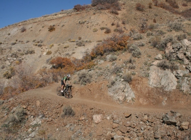
View south on Rattler on a hazy fall
day. Trail review and photos by Bruce on October 23, 2013.
|
| The Rattler Trail opens up some new riding options for the
unloved eastern side of Corner Canyon. Rattler has a trail-base that
should hold up well in winter. The exposed slopes should pack down or
melt off quickly. Rattler is NEVER closed by rain or snow! I foresee this trail becoming a winter-riding
favorite.
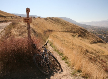
Northern end of Rattler. It forks
off the BST just below the Corner Canyon Road trailhead where the BST
crosses.
|

|
 |
The combination of lower Corner
Canyon, the eastbound Corner Canyon
BST, and Rattler forms a set of trails that you can ride any time,
regardless of snow or rain conditions. (See the Corner
Canyon website for closure information for other trails.)
Rattler itself is a little over a mile in length. It runs
generally uphill as it heads south into the canyon. The trail-base is
broad and smooth. There are only occasional trees to block your view of
the valley.
View on the southern end as we
descend from Corner Canyon road toward the trail fork. From this spot we
can drop to the Ghost Falls trail or reverse and head north downhill on
Rattler. A new trail will continue further uphill to the south. |
| I scoped out a couple of riding options for you. One is a
quick loop tour of the trail, crossing the canyon from Coyote Hollow on
the BST and returning via Canyon
Hollow. See the description below. Once
you've done this little loop, it will give you ideas about how to fit
this trail into your ride plans for Corner Canyon.
Approaching Rattler from above on
the BST, with the Draper temple appearing over the handlebars.
|

|
 |
The second described ride is specifically for winter
months. A combination of the Corner Canyon road, Rattler, and Aqueduct
can give you several miles and a good workout when other trails are
muddy or buried in snow.
The GPS track files below include a third ride, a 9-mile loop from
the Equestrian Center. It uses Corner Canyon, BST,
Rattler uphill to Ghost Falls, Canyon
Hollow, Rush, and Creekview.
Typical trail segment. There are a
few trees that will offer short damp segments in the winter. Don't hurt
the dirt. Draper City will be watching this first winter to see how the
trail holds up when damp. |
| Most of the trail is relatively easy riding with gradual
slope and gentle turns. There are frequent views over Corner Canyon
below and of the valley to the northwest.
From the BST on the north (downhill) end to
Ghost Falls (just uphill
from the merging of Rattler with the Ghost Falls trail) is 1.3 miles.
From Ghost Falls, you can either head over to the Canyon Hollow trail on
the west or continue south uphill on the upper Ghost Falls trail to the
trailhead on the Corner Canyon Road.
Meandering toward a soft turn
descending the trail.
|

|
 |
At one point (just downhill from the trail fork where
Rattler splits), the trail clings to the edge of a rock
outcrop as it skirts a ravine. It's not tricky, at least not on a dry
October day. But the exposed slope will give beginning riders fits. And
it will be interesting to see how the shady spot in the ravine rides
when covered in snow and ice.
Mitt rolls around an outcrop of
limestone on Rattler. |
|

|
 |
Coyote to Rattler via BST and returning on Canyon
Hollow
This is a quick loop tour that will introduce you to the trail. It
starts from the Coyote Hollow trailhead. Keep northeast and generally
downhill in the bottom of the hollow. As you arrive at a confluence of
dirt road, find the singletrack heading toward the creek. Cross the
bridge and climb the Bonneville Shoreline to Aqueduct, then climb again
on the BST. Fork hard right when you reach Rattler. Follow Rattler
uphill, then descend to the Ghost Falls trail. (NOTE: for an extra mile,
take the fork continuing uphill to Ghost Falls itself. You'll connect to
Canyon Hollow further uphill.) Quickly find your way across the
creek (left, then right, then right) to descend Canyon Hollow. |
Riding guide, Coyote Hollow to Rattler
Loop:
0.0 East from circle N40 29.612 W111 50.328
100 feet keep straight (R =
Clarks and BST)
N40 29.616 W111 50.309
0.1 Veer L (R = Canyon Hollow/Silica Pit)
N40 29.627 W111 50.288
0.2 Straight and downhill on broad trail
N40 29.667 W111 50.230 (L =
Creekview)
0.3 Keep straight to ST N40 29.762 W111 50.120
100 feet, R on ST N40 29.800 W111 50.111
Cross bridge
0.7 Slight L onto broad Aqueduct Trail
N40 29.973 W111 50.129
0.8 R uphill on continuing BST
N40 30.056 W111 50.162 |
1.1 Hard R onto Rattler
N40 30.181 W111 50.080
1.9 Straight (R = to CC road)
N40 29.878 W111 49.754
100 feet then R downhill
2.1 L on Ghost Falls N40 29.784 W111 49.635
100 feet, then R N40 29.767 W111 49.621
(L=to Ghost Falls for longer
ride)
Cross bridge, R downhill on
Canyon Hollow
2.4 Keep straight (R = down to DT)
N40 29.742 W111 49.838
2.6 Cross Rush (keep straight)
N40 29.713 W111 49.925
2.9 Keep straight N40 29.632 W111 50.286
3.0 Back at trailhead |
 |
Equestrian to Rattler to Canyon Hollow to Rush Loop
This 9-mile loop has 1200 vertical feet of climbing. It starts at the
Equestrian parking on Highland and climbs Corner Canyon south to the BST
(northbound). It does another 180 onto Rattler and continues to Ghost
Falls. Crossing the ravine, it climbs to Canyon Hollow and turns uphill.
Fork onto Brocks to the Peak View TH, then descend Rush. Go west uphill on
the DT BST to Creekview and descend back to parking. |
Riding guide, Equestrian Rattler to Rush
Loop:
0.0 Begin climb on Corner Canyon across road
N40 30.323 W111 50.721
0.5 TH, keep R on ST (L = shortcut to Aqueduct)
N40 30.105 W111 50.385
0.6 Join DT, continue uphill N40 30.057 W111 50.328
0.9 Keep L N40 29.827 W111 50.152
100 feet then L and across
bridge (BST)
N40 29.801 W111 50.097
1.3 Slight L onto broad Aqueduct Trail
N40 29.973 W111 50.129
1.4 R uphill on continuing BST
N40 30.056 W111 50.162
1.7 Hard R onto Rattler
N40 30.181 W111 50.080
2.5 Straight (R = to CC road)
N40 29.878 W111 49.754
100 feet then L and level
N40 29.863 W111 49.724
2.9 Join Ghost Falls (straight)
N40 29.756 W111 49.362 |
3.0 Pass falls, 100 feet then R
N40 29.743 W111 49.301
(L = upper Ghost Falls trail)
3.1 Hard L climb Canyon Hollow
N40 29.731 W111 49.423
4.0 Hard R to Brocks N40 29.540 W111 49.082
4.4 Peak View TH, R to Rush
N40 29.292 W111 49.248
4.9 R to The Trees N40 29.263 W111 49.431
5.9 Rejoin Rush N40 29.461 W111 49.437
6.6 Keep L (R=to Canyon Hollow)
N40 29.670 W111 49.583
7.3 Cross Canyon Hollow N40 29.716 W111 49.929
7.6 Out to DT then L uphill (BST)
N40 29.762 W111 50.115
7.7 R on Creekview N40 29.667 W111 50.231
8.6 Cross bridge then L N40 30.146 W111 50.502
9.0 Cross road to parking
|
 |
Winter ride, Rattler via Corner Canyon road and
Aqueduct.
This ride is on exposed slopes that should melt down or compact well
in winter. There are several possible variations that combine Aqueduct,
Sadler, Quail, and the BST. The simple route below puts the snowiest
spots on the downhill and uses the gravel road for most of the climbing.
Start uphill from the parking at the bottom of the Corner Canyon road.
Grunt uphill all the way to where Rattler forks away. Descend Rattler to
the BST. Fork L downhill. Go L again on Aqueduct. Ride Aqueduct downhill
to the CC road. However... If Quail or Sadler looks relatively snow-free
and interesting, climb back to the road and head uphill. This time, drop
down BST to Rattler and ride a more-difficult loop in the other
direction. |
Simple winter loop, riding notes:
0.0 Uphill from CC parking N40 31.209 W111 50.099
0.2 Keep straight on road (Aqueduct crosses)
N40 31.074 W111 50.134
0.5 Stay on road (Sadler descends R)
N40 30.786 W111 50.160
0.7 Stay on road (Quail descends R)
N40 30.648 W111 50.157
1.0 Stay on road (BST TH on R)
N40 30.351 W111 50.085 |
1.6 R downhill on Rattler N40 29.939 W111 49.767
1.7 Hard R N40 29.879 W111 49.754
2.5 Hard L down BST N40 30.181 W111 50.080
2.8 R on Aqueduct N40 30.067 W111 50.164
(Dry day option, L = back to
Gasline and BST
for connections to Ghost
Falls and Canyon Hollow)
3.3 Quail on R (option) N40 30.430 W111 50.261
3.6 Sadler on R (option) N40 30.715 W111 50.241
4.0 Join CC road
4.2 Back at parking |
| Variations on the Aqueduct-Corner Canyon Road leg of
the winter ride
In addition to the Bonneville Shoreline Trail, two other trails link
the Aqueduct Trail to the Corner Canyon road. Both descend to the
southwest (going roughly parallel) which makes most riders select one or
the other, instead of combining both into one ride. Both trails are
sun-exposed and sandy, so there's not much worry about rutting them in
the winter.
|

|
 |
The Sadler Trail is the first trail you'll encounter
when climbing uphill. It's plainly the least-loved of the two trails, as
measured by the in-growth of grass. Sadler is 0.2 miles long and forks
off the road at 1/2 mile uphill from the parking area. |
| The Quail Trail (often used as part of the Draper ICup
race) drops off the Corner Canyon road at 0.7 miles. It's 0.3 miles in
length.
Select one trail to ride down and one to go back up. Or not.
|

|
 |
Getting there, Coyote Hollow trailhead: Take the Bluffdale exit from I-15 and turn
east towards the mountains. Climb the hill as above, but turn right at the
light on Traverse Mountain Road. After one mile, turn into Mike Weir Drive
on your left. Pass the Mike Weir trailhead 1/2 mile later and continue
another half mile until the road veers left downhill. Take the next right
turn, turn right again, then left. You should now be on Gray Fox Drive.
Take the next right into Coyote Hollow Court. The parking is on the right
at the end of the pavement.
Corner Canyon Road: Drive east on Draper Blvd (123rd South) to
13th East. Turn right down the hill. At the traffic roundabout, to east
(90 degrees left) onto Pioneer Road. Go towards the mountains to 20th
East, then turn right. After 1/4 mile, turn left into the trailhead
parking area and begin riding uphill on the gravel road that was
immediately on your right as you entered the parking lot. (GPS N 40°
31.281' W 111° 50.081').
Bathrooms: BST trailhead, Equestrian center
Water: Equestrian center |
| Equestrian Center parking:
Take the Bluffdale exit from I-15 and turn east towards the mountains on
Highland Drive. Go straight past the railroad underpass. Stay on Highland
until you reach the parking area for the Lynn Ballard ball park on your
left. To find the trail, go to the west end of the parking area near the
trail kiosk. Drop down the hill and turn left into the tunnel under the
road. (Or go directly across the road and find the ST climbing up the
opposite side.) After climbing out of the tunnel, turn left and climb back
up. The uphill trail is directly across from the entrance into the parking
area (GPS N 40° 30.351' W 111° 50.721'). To reach the trailhead from the
north (Sandy area), take 13th East southward until it ends at the stop
sign just past the underpass. Turn left and drive 1/4 mile to the ballpark
parking. |
|


