 |
The Whole Enchilada
Geyser Pass, Burro Pass, Hazard, a piece of
Kokopelli (or Jimmy
Keen), Porcupine Singletrack, and Porcupine Rim - an Epic
La Sal to Colorado Ride
This ride is 28 miles long, with 7000 vertical feet of downhill. It's
an unforgettable epic experience, but is only for strong, skilled,
and adventuresome riders. It peaks at 11,200 feet in the La Sal Mountains
and drops to the Colorado River. Climbing will total about 2200 feet.
Note: 2017
La Sal Loop road closure information
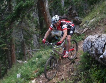
Chad descends a typical steep section
of Burro Pass. September 3, 2007. |
|
You'll need a shuttle vehicle. Leave one vehicle at the Grandstaff (Negro Bill
Canyon)
trailhead, and drive the other to the Burro Pass trailhead. Or just cough
up the bucks for a commercial shuttle to Geyser Pass. From the
ride's finish-line, the trailhead is 35 miles and 6000 vertical feet away. The
riding season for the Burrow
Pass section is mid July through September. Start the ride |
| Geyser Pass Section [
link to trail page ]
The Geyser Pass Singletrack is a newer segment of the Whole Enchilada,
proving a nice plush singletrack route from parking at Geyser Pass to the
Burro Pass trailhead. This segment is 1.5 miles long, with 150 vertical
feet of climbing. But you'll actually lose a total of 200 vertical feet
between Geyser Pass and the Burro Pass trailhead, going from 10,500 to
10,300.
View east as we pass through a meadow.
Mount Tomasaki is straight ahead. |

|
 |
From the trailhead, you have two options to find the trail.
You can go to the right of the kiosk, then veer left onto the Geyser
Springs road (071). Most riders will hop on the singletrack between the toilet and the
kiosk. This will take you past a picnic table before dumping you onto the
doubletrack after about 100 yards.
You'll quickly come to a fork in the dirt road 0.1 miles
from the trailhead. The right fork is FR 071 heading east, with a
connection uphill to the Burro Pass trailhead.
This is the old route. Instead, keep left on FR 243. The fork in the road
is marked with a nice sign (as of 2015). Just uphill along the side of the
left fork, you'll also see the little "WE" sign that marks the
Whole Enchilada route.
The trail passes through groves of
aspen. |
| Pedal on a bit uphill. In less than 100 yards, you'll see
the singletrack (marked with the "WE" sign) branching away from
the doubletrack on your right. The trail begins a gentle climb.
After a mile, the trail will begin to drop into the little
canyon south of Burro Pass. When you reach
a doubletrack heading straight uphill, turn left and climb. The Burro Pass
trailhead will be on your right, about 200 feet uphill.
View west as we turn onto Burro Pass. |

|
The Whole Enchilada, ride description:
Begin from Geyser Pass parking
0.0 ST between toilet and kiosk
N38 29.122 W109 13.940
0.05 L on ST N38 29.163 W109 13.932
0.1 L at DT fork N38 29.197 W109 13.913
0.15 R on Geyser Pass ST
N38 29.228 W109 13.930
|
1.5 Left uphill on Burro DT
N38 29.756 W109 13.056
1.55 Burro Pass trailhead
N38 29.801 W109 13.036
Keep straight and uphill
...proceed to Burro Pass segment |
| Burro Pass Section [
link to trail page ]
Most riders will already have started from the Geyser Pass trailhead. (The
official Burro Pass trailhead is remote
and may not be drivable after a rain or in early summer, with the last 1/2 mile
very steep and rutted.)
From the official trailhead at 10,400 feet, you'll ride uphill 800
vertical feet in 1.2 miles. Unless you're superhuman, there will be some
hike-a-bike sections. (20% slope at 11,000 feet is tough!) Enjoy the
beauty. Later on, you'll be too busy flying downhill and trying not to
crash.
Crossing the ridge, you begin a steep switchback descent. This is fun
stuff, with some technical challenges involving loose rock, roots, and
very tight switchback turns.
Bruce drops over a root section. Photo
by Mike. |

|
 |
After a couple of miles, the trail mellows. You're riding
through fir with occasional meadows and aspens. You'll plunge through the
creek a few times.
As you reach the aspen zone, you may actually have to pedal a bit. When
you reach a water-diversion ditch, you're almost done with Burro. We took
the trail over the ditch and uphill across a small mountain. It looks like
you can ride along the ditch and meet the trail later near Warner Lake.
Chad rockets through the creek.
|
| At the 4-way intersection, keep right, go through a squeeze gate and
past a small lake. At the back of the Warner Campground, you've finished
the Burro Pass section. |
Begin Burro Pass Section
...you are at the Burro Pass trailhead
1.5 Start uphill through the trees
N38 29.801 W109 13.034
Step through the gate
onto ST
2.7 Ridge, cross and start downhill
N38 30.214 W109 13.654
Switchbacks, loose, steep
4.7 Fork L downhill
N38 30.701 W109 15.143 |
5.3 Cross ditch R uphill
N38 30.53 W109 15.68
(approx)
6.3 Fork R, go through squeeze gate
N38 30.989 W109 16.437
Pass by lake
6.5 DT Warner Campground
N38 31.161 W109 16.519
Follow main road out of
CG
...Proceed to Hazard County |
| Hazard County Section [
link to trail page ]
Head out of the Warner Campground on gravel road. Descend a bit, then
when the trail starts uphill, fork right on gravel road to the Hazard
trailhead. Start uphill on singletrack. You'll make a fairly stiff climb
of about 1/2 mile.
Mike cranks uphill on Hazard, with
Warner Campground and the end of the Burro Pass trail above his head. |

|
| At the crest of the hill, you enter a zone of armored gap-jumps. Do
them if you dare. There's a big penalty if you don't clear the gap! You
leave aspen and enter a gambel oak area, like an uber-Lambert Park. |
 |
The trail twists sharply in a fun downhill romp. Some turns
have armored kick-offs, and there are occasional stunt opportunities. If
you do the trail more than once, you'll get familiar with what's coming
up, and can push a little more speed.
Chad approaches a gap jump on Hazard
County.
|
...You are following the gravel road from
Warner Campground
Begin Hazard County Section
7.0 As road starts uphill, fork R uphill
N38 31.460 W109 16.806
7.1 Hazard County TH on R of parking
N38 31.532 W109 16.907
Up hill, then long
twisting descent
10.4 Meet La Sal Loop Road
N38 32.545 W109 18.736
...Proceed to Kokopelli
Dominic lands the bike after a jump on
Hazard County. |

|
 |
The Kokopelli starts as a dirt doubletrack surrounded by grass and oak
brush, right across the road from Hazard. At first, it's a gentle downhill slope, with a bit of occasional
uphill. The terrain becomes dryer, giving way to rocky jeep road
surrounded by pinion and bitterbrush.
Mike and Chad rattle down a rocky
section of Kokopelli. |
| The Kokopelli is the lowest-voltage section of the ride, but hey, it's
all good.
Singletrack lovers and tech riders will skip the lower half of Kokopelli and descend
via the Upper Porcupine Singletrack. |
| About 100 yards past a small elevated ride-over cattleguard in the
fence, there's a singletrack climbing up on the right. That's the start of
UPS (Upper Porcupine Singletrack). Proceed down Kokopelli, or rail the UPS by
forking right.
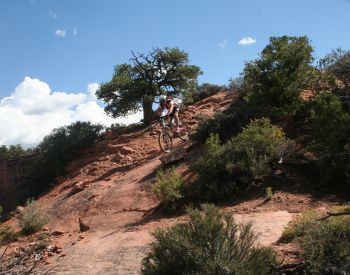
Chad takes a little air on an
open-rock section of the Kokopelli.
Begin Kokopelli Section
Cross La Sal Road onto DT
11.9 Through fence over hiking cattleguard
12.0 Upper Porcupine Singletrack forks R
N38 33.706 W109 19.649
Fork R for UPS option, L for Kokopelli Options |

|
UPS (Upper Porcupine Singletrack) Option
Fork R on UPS at mile 12
14.0 Overlook at DT, cross to ST
N38 34.529 W109 20.767
15.0 R at ST fork (L=Sand Flats Rd)
N38 34.842 W109 21.453
All options now converge on same ST fork. See below |
Kokopelli Options
Stay on Kokopelli
at 12.0
13.4 Sand Flats Rd, fork R uphill
N38 33.880 W109 21.114 |
Sand Flats Road Option 1
14.4 Fork R on DT
N38 34.428 W109
21.351
15.0 At overlook, find ST on L
N38 34.529 W109
20.767
16 R at ST fork (Add 1 m to distance)
Porcupine Singletrack
N38 34.842 W109
21.453 |
Sand Flats Road Option 2
14.4 Stay L on Sand Flats Road
N38 34.428 W109 21.351
14.8 Cross cattleguard, R on ST
N38 34.709 W109 21.510
15.0 L at ST fork onto LPS
Porcupine Singletrack
N38 34.842 W109 21.453 |
|
 |
Jimmy Keen is a singletrack trail finished by the National Forest
Service in late fall 2014. It's an excellent alternative to riding Kokopelli,
connecting you from Hazard County to the Upper Porcupine Singletrack. The
trail takes a large meander out through Jimmy Keen Flat. You'll do some
climbing on this trail, and its meandering course will add significantly
to your time and miles. At almost 8 miles, it's over four times as long as the straight shot
down Kokopelli.
You can reach Jimmy Keen either from the viewpoint on the La Sal Loop
road just north (to your right) as you finish Hazard County, or you can
pedal down Kokopelli to the point where the trail crosses.
The Jimmy Keen Trail opened November
2014. My formal trail review is pending. |
 |
The porcupine Singletrack stretches from the mid-Kokopelli down to the
Castle Valley overlook on the Porcupine Rim trail. It's divided into Upper
and Lower Sections. This is IMHO the best part of the ride. Quick moves on
singletrack through pinion forest with patches of slickrock. Lots of
dropoffs.
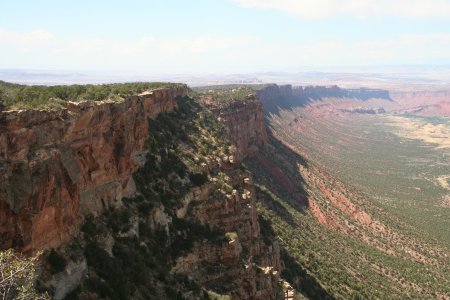
Looking northwest along the Porcupine
Rim as the Porcupine Singletrack flirts with the cliff edge. |
| The connection to the UPS (Upper Porcupine Singletrack) is about
half-way down the Kokopelli, just after crossing the fence. To skip the
UPS, stay on Kokopelli then turn right on
Sand Flats road. |
| If you ride Kokopelli to the Sand Flats Road, the next opportunity to catch the Porcupine Singletrack is
found 1-1/2 miles down the Sand Flats Road. Turn right as you finish
Kokopelli. As the road turns hard left to a long straight section, there's
a doubletrack on the right. This is a primitive camping area. If you go
all the way to the end, overlooking the rim, you'll find the singletrack
crossing the turnaround area. Go left downhill.
The second connector from Sand Flats Road to the Porcupine Singletrack is 2-1/2 miles from Kokopelli. As you ride the
straight section of Sand Flats, cross a cattleguard and spot a singletrack
on the right (going north). Follow this about 1/2 mile to a T intersection
and turn left.
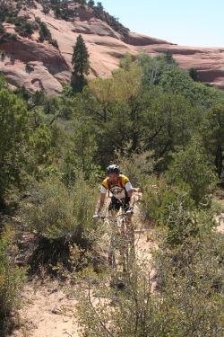
Mike cruises the singletrack through
rock and brush. |
|
| You'll cross a deep gorge on the lower section. The trail drops down an
impossibly-steep cliff to your right. Hoof it to the bottom. Apparently,
some superhuman types actually ride this. Chances are, that's not going to
be you.
The Porcupine Singletrack is a nice combination of twisting singletrack, open rock, and small challenges. It's pretty straightforward
to ride downhill. We did it uphill as well, and found it a
significantly-harder challenge both in riding and following the trail as
we hit open rock areas. |
 |
...From the T intersection of Lower
Porcupine Singletrack
Lower Portion, Porcupine Singletrack
15.0 From ST fork proceed northwest
(L if coming from
cattleguard, R if already on LPS)
Hike down Big Dip
16.8 At Porcupine Rim overlook
N38 35.656 W109 22.637
...Go right on Porcupine Rim DT
Chad heads down a slickrock patch in
the middle section of the Porcupine Singletrack. |
| Porcupine Rim Section
[ link to trail page ]
The Porcupine Rim section begins at the Castle Valley overlook. This is
about 4 miles from the start of the Porcupine Rim ride, and skips almost
all of the climbing. Head right and follow the Porcupine Rim trail DT,
slightly uphill as it parallels the rim.
Mike flies off the diving board on
Porcupine Rim.
|

|
| An alternate would be to head the opposite direction, back to the
Porcupine Rim trailhead on the Sand Flats Road. I'm not sure why you'd
want to. But it does provide a quicker bail-out route if you need to quit.
The Porcupine Rim section is 11 miles long.
It's a fast ride for skilled bikers, but can be a bit rough. There are a
few doubletrack spurs that fork off the trail, but trail signs show the
right way. If you don't see a sign, follow what appears to be the main
track. |
 |
As you reach the singletrack lower section
you'll hug the top of the cliff before dropping to the Colorado River.
There are some technical sections that only the most skilled can clear.
Begin Porcupine Rim Section
Castle Valley overlook
West (right) on DT
Follow Porcupine Rim down
28.0 At highway |
Getting there, Geyser Pass TH:
On Moab's Main Street, head south on US-191. Zero your odometer at Center
Street Center Street and drive 8.2 miles. Turn left toward Ken's Lake - La
Sal Loop Road. At the T intersection 1/2 mile later, turn right. Stay on
the paved La Sal Loop Road to mile 20.6, then turn right on gravel Geyser
Pass road. After several miles the road narrows to a single lane. Drive 8
miles on Geyser Pass road (to mile 28.6) until you see a bathroom, kiosk,
and parking on your left with a road fork straight ahead. This is
Geyser Pass (N38 29.122 W109 13.940). |

|
| Burro Pass (old) TH: As you pass the parking
area, go left (you should see a "Burro
Pass 1.2" sign as you curve around the fork), then keep right at the
fork that immediately follows. 1.2 miles later (mile 29.8) turn left off
the main road on an eroded doubletrack climbing steeply up the mountain,
with a sign "Burro Pass TH" (N38 29.408 W109 12.906). Go 1/2
mile up the mountain (4-wheel drive strongly suggested here) and park on
the right side where the DT disappears into some fir trees. The sign indicating the singletrack trailhead, and a
step-around squeeze gate, is in those trees uphill from you. |
|


