 |
Porcupine Singletrack
These trails are also part of The Whole Enchilada
ride.
The Porcupine Singletrack runs along the edge of Porcupine Rim through
a region of brush and pinion pine. It's higher on the mountain than the
more famous Porcupine Rim trail. Both of the rides we describe here use
part of the Porcupine Rim trail.
Note: 2017
La Sal Loop road closure information
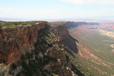
View down the Porcupine Rim from the
Kokopelli. September 3, 2007. |
|
(1) Shuttled Downhill: Kokopelli
trail (or a longer fun route on singletrack Jimmy
Keen) to the Porcupine Singletrack, then down the last 11 miles of Porcupine Rim.
(2) Loop: From the Porcupine Rim trailhead, go up Sand Flats Road to
one of three possible intersections of the Porcupine Singletrack, descend
the ST then go the "wrong way" on the first 4 miles of Porcupine
Rim to close the loop. |
| The Porcupine Singletrack is a nice combination of twisting
singletrack, open rock, and small challenges. It's pretty straightforward
to ride downhill. We did it uphill as well, and found it a
significantly-harder challenge both in riding and following the trail as
we hit open rock areas.
Upper Kokopelli Trail, shortly after
leaving the La Sal Loop Road for the shuttled downhill version of the
ride.
|

|
| For a shuttled downhill ride, intersect the Kokopelli
trail
on the La Sal Loop Road. (It's right across from the downhill end of the Hazard
County trail.) The Upper Porcupine Singletrack is found about
half-way down, just after passing over a cattleguard in a fence. The
singletrack is on the right heading uphill. [Note: In the past, the UPS
was considered an "outlaw trail. As of April 2009, the UPS is now
legal.]
Follow the singletrack down. If you're confused as you reach
open-rock area, just keep to the right and north as you descend the
steepest side of the rock. When the trail hits an open area at the rim
with a doubletrack, cross to the ST on the other side. The DT is a bailout
route to the Sand Flats Road. At the next ST
trail fork, go right (left takes you to Sand Flats Road by the cattleguard).
A bit later, cross the big gulley by dropping to your right off
the cliff. (Yeah, go ahead and ride it. I'll watch.)
|
 |
The singletrack ends on the Castle Valley overlook of the Porcupine Rim
trail. You'll know the spot -- there's a broad area of rock right on the
cliff edge, with a doubletrack skirting it on the downhill (south) side.
From the overlook, head to the right and slightly uphill. Follow the
Porcupine Rim trail for the next 11 miles.
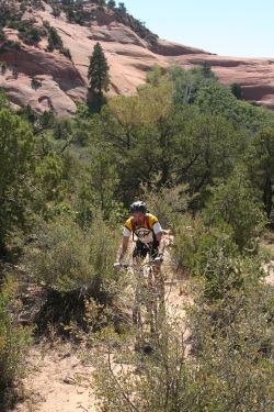
On the lower Kokopelli, Mike navigates
through a slickrock area. |
| The loop ride uses the Sand Flats road to get you to the top
of the Porcupine Singletrack. If there's no parking at the Porcupine Rim
trailhead, go on up the Sand Flats road and find another spot. There are
three opportunities to catch the singletrack, depending on the length of
ride you want. See the map.
(1) Shortest ride. As you head uphill on Sand Flats Road,
find the singletrack on your left just before a
cattleguard on the road. Fork left at the trail fork 1/2 mile later.
|
| (2)
Funner, longer. Continue past the first trailhead, another mile up Sand
Flats Road. Turn into the doubletrack on your left as the road turns hard right. The
DT takes you through a camping area. Proceed to the rim and find the ST on the
left at the overlook. (3) Whole UPS. Continue on Sand Flats until the doubletrack
Kokopelli Trail forks
left uphill. Follow the Kokopelli uphill until you reach ST on your left,
about 100 yards before a fence that crosses the Kokopelli.
Dominic rolls out of the Kokopelli as
it reaches Sand Flats Road. |

|
 |
Loop ride, counterclockwise from Porcupine
Rim Trailhead
0.0 Start up Sand Flats Road
N38 34.906 W109 25.014
3.8 Cattle guard, first access is ST on L (fork L in 1/2 mile)
N38 34.709 W109 21.510
4.1 DT on L, access #2 at end of DT (3/4 mi @ N38 34.529 W109 20.767)
N38 34.428 W109 21.351
5.1 Kokopelli Trail on L, go uphill
N38 33.880 W109 21.114
6.5 Upper Porcupine Singletrack forks L uphill
N38 33.706 W109 19.649
8.2 Overlook at DT, cross to ST
N38 34.529 W109 20.767
9.1 R at ST fork (L=Sand Flats Rd)
N38 34.842 W109 21.453
Hike through Big Dip
10.9 At Porcupine Rim overlook
N38 35.656 W109 22.637
. South (left) on Porcupine Rim DT
14.0 Back at Porcupine Rim TH
Mike rocks along the Porcupine
Singletrack. |
|
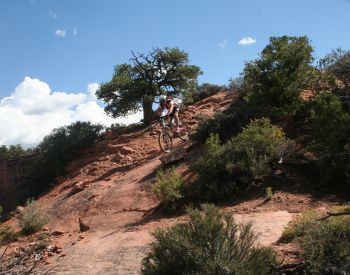
The Porcupine Singletrack has a lot of
quick turns and fun but not-too-hard rock drops. It will remind you of
Gooseberry Mesa. Here Mike hits a bit of rock.
Downhill, starting with Kokopelli, ending at Colorado River
(Shuttled ride)
0.0 Left off La Sal Road onto DT
N38 32.545 W109 18.736
1.8 Through fence over hiking cattleguard
N38 33.652 W109 19.599
1.9 Upper Porcupine Singletrack forks R
N38 33.706 W109 19.649
Fork R for UPS option, L for Kokopelli Options |

|
UPS (Upper Porcupine Singletrack) Option
Fork R on UPS at mile 1.9
3.7 Overlook at DT, cross to ST
N38 34.529 W109 20.767
4.6 R at ST fork (L=Sand Flats Rd)
N38 34.842 W109 21.453
All options now converge on same ST fork. See below |
Kokopelli Options
Stay on Kokopelli
at 1.9
3.3 Sand Flats Rd, fork R uphill
N38 33.880 W109 21.114 |
Sand Flats Road Option 1
4.3 Fork R on DT
N38 34.428 W109 21.351
4.9 At overlook, find ST on L
N38 34.529 W109 20.767
5.8 R at ST fork (Add 1 mile)
Porcupine Singletrack
N38 34.842 W109 21.453 |
Sand Flats Road Option 2
4.3 Stay L on Sand Flats Road
N38 34.428 W109 21.351
4.6 Cross cattleguard, R on ST
N38 34.709 W109 21.510
4.8 L at ST fork onto LPS
Porcupine Singetrack
N38 34.842 W109 21.453 |
|
 |
...From the T intersection of Lower
Porcupine ST
(mileage assumes UPS route)
Lower Portion, Porcupine Singletrack
4.6
From ST fork proceed northwest
(L if coming from
cattleguard, R if on LPS)
Hike down Big Dip
6.3 At Porcupine Rim overlook
N38 35.656 W109 22.637
. West (right) on Porcupine Rim DT
Follow Porcupine Rim down
17.4 At highway
Chad drops down some open rock to grab
some more twisting singletrack. |
|

|
Getting there, loop ride from Porcupine Rim
trailhead: The Porcupine Rim Trail begins on the Sand Flats Road,
reached by turning left off Moab's main drag onto 300 South, then right
when the road ends, then second left. From the entry gate, drive 7 miles.
The trailhead is on the left, near the small cattle-watering tanks.
Shuttle ride from La Sal Loop Road: Leave your shuttle car in
Moab, or at the Grandstaff Canyon parking area on highway 128 north of
Moab. (Grandstaff Canyon will be listed as Negro Bill Canyon on any maps
created prior to 2017. The canyon is named after William Grandstaff, a
black cowboy who ran cattle in this area in the 1870s.) On Moab's Main Street, head south on US-191. Zero your odometer at
Center Street Center Street and drive 8.2 miles. Turn left toward Ken's
Lake - La Sal Loop Road. At the T intersection 1/2 mile later, turn right.
Climb uphill on the paved La Sal Loop Road. Around mile 25, watch for a
doubletrack on the left with a sign "Kokopelli Trail." Start
your ride downhill here. |
|


