 |
Kokopelli Trail
The Kokopelli Trail is a series of dirt roads and doubletrack trail
from Loma Colorado to Moab Utah. The Kokopelli route is 142 miles with around
14,000 vertical feet of climbing. Most riders do only a small section of
Kokopelli as
part of another ride. The entire trail can be done as a multi-day camping
ride, or as a monster one-day event.
Note: 2017
La Sal Loop road closure information
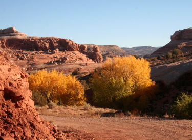
Chad in the Fisher Valley. Photos are by Bruce
from various rides 1998 through
2015. Page compiled 2016. |
| Much of the ride will be exposed to
hot sun at around
5000 feet elevation, but the route goes over the La Sal Mountains at 8500
feet, where severe storms can erupt suddenly. Plan for extreme
temperatures and weather. Riding season is mid-June through September, depending on
snowmelt in the higher elevations.
Looking east over the Colorado near Westwater. Around mile 30 on
Kokopelli. |

|
 |
There are towns at each end of the trail (Fruita on the east and Moab on the
West). But while on-trail, there's no nearby
option for re-supply. Riders will need to (1) go as part of a commercial
group, (2) arrange meetings with a support vehicle, or (3) stash supplies
along the trail before the ride. (See the topo map link below for
suggested re-supply stash locations.)
The trail skips between rough-and-tumble jeep path and improved
gravel roads. We're heading towards a picturesque Entrada sandstone butte
on the eastern half of the ride. |
| There are a couple of shortcut or bailout options. These
should be obvious from the map. For example, some riders bypass a particularly nasty
rock-and-sandfest section (Yellowjacket Canyon area) by turning onto
Highway 128 where the trail crosses the highway. The reconnect spot is at the Dewey
Bridge after crossing the Colorado. Mike, Chad, and Matt crank up Kokopelli. Get
used to juniper and sage brush. There's a lot of it. The upside to dirt
road is, the views are better and you can look around while you pedal. |

|
 |
Highway 128 at the Colorado also functions as a
bailout for westbound riders, connecting to Highway 191 at the north end
of Moab. Another bailout is the paved La Sal Loop road. Eastbound
riders can bail by transferring to paved road in Coal Draw (just southwest
of Westwater), crossing I-70
to Highway 6 for a road return to Loma. Southbound a few
miles past the Dewey Bridge. While much of the trail is rough and remote,
a fair portion of the Kokopelli is family-sedan type improved gravel
roads. If you hate long scrunching crankfests on washboard road -- like I
do -- well, maybe this isn't your thing. |
| Most riders go westbound from Loma to Moab. This puts
much of the climbing later in the ride as you tackle the La Sal Mountains. But in
exchange, the final stretch is less technical and is easier to manage when
you've run out of daylight.
When driving out from Moab, you can stop at your planned
"stash" spots along the Kokopelli trail. There's some dirt road
involved in reaching these spots, as
well as potential for confusion. So
add a couple of hours to your usual Moab-to-Fruita drive time.
Matt cruises Kokopelli heading towards Fisher Valley above Onion Creek. We're below the Wingate
sandstone cliffs at this spot. There's a long climb after crossing the
Colorado, followed by a descent back to the Fisher Valley, then another
long climb to 8500 feet. These two "bumps" on the second half of
the Fruita-to-Moab ride are around 2500 vertical each. |

|
|

|
Most riders do the ride as a 3- to 5-day camping trip using a support
vehicle between overnight stops. There are small campgrounds with
bathrooms (but usually no water) along the trail, and a couple of major
campgrounds just off trail. Significant research will be required on your
part! Heading uphill into the La Sals, as the trees change from sparse
juniper to longleaf pine and pinion. Late June or early July are the best
times to ride, both for longer days and less chance of a nasty afternoon
thunderstorm in the La Sal Mountains. |
| For multi-day riders, there will be opportunities to hit
other trails, such as the Western Rim,
Top of the World, Jimmy
Keen, and Porcupine Rim, either as an add-on
or as a substitution for a section of the Kokopelli.
The trail is fairly well-marked, usually with large signs. But unless
you're on a guided trip, you'll need to do a bit of homework. It takes careful planning to make this ride fun and safe.
Looking west on Kokopelli as we descend from the La Sals. We've just
left the La Sal Loop road. |

|
|

|
If you aren't using stashes or a support vehicle, hydration will be a
challenge. There are a few water sources near the trail. You'll need a
water purifying system. East to west, water can be found at Westwater
Ranger Station (about 1-1/2 mile off trail), Cottonwood Creek (5 miles
after crossing Colorado), Hideout Campground, and Fisher Creek at the
Castle Valley Road. Looking west as we reach cliff edge. We're
approaching the
Porcupine Singletrack -- a nice option if you've got the time. |
| It's
possible to hammer the ride in a single day with a cranking time of
around 16 hours. This is a monster ride reserved for only the fittest of
expert riders. If you're not using a support vehicle, stash supplies and as-needed gear (such as lights) along
the trail as you drive from Moab to Colorado.
Mike and Chad descending lower Kokopelli to the Sand Flats Road. The Slickrock
parking lot is now just 13 miles away. |

|
|
Sorry, I don't have a by-the-mile ride instruction for
you, because I haven't done the whole thing in one gulp. Yet. Good
luck, Bruce. |
 |
Because of the logistic difficulties, isolation, and
hazards of doing the entire route,
riders are encouraged to make their first full-length Kokopelli
ride with an experienced group or as part of a
professionally-supported ride.
Pages on this site that use portions of Kokopelli:
Fruita
Onion Creek
Top of the World
Western Rim / Westwater
Whole Enchilada
GPS Track of Kokopelli from Loma to Slickrock parking:
Download
GPX
Overview topo map for printing, showing campgrounds and cache vehicle access:
View map |
|


