 |
Speedbag Loop
Tour des Suds to Midmountain to Little Chief to
Speedbag
This is a quick loop ride of 6 miles at relatively middle altitudes for
Park City. The ride starts in Daly Canyon, extends to Midmountain
via Tour des Suds, detours onto Little Chief
then drops down Speedbag. It's intermediate technical with 1000 vertical
feet of climbing to a top altitude of 8300 feet.
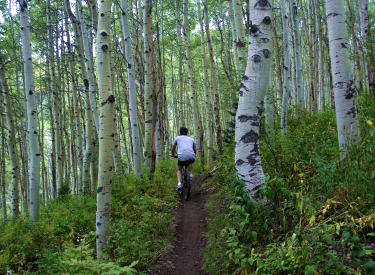
Looking down Speedbag as we plunge
through aspen forest. Photos and track by Bruce on September 15, 2011. |
| Because there are only a few roadside parking spots in Daly
Canyon (the continuation of Park City's Park Avenue), riders may want to
start from other spots in the city. From Deer Valley, take Rossi Hill (see
the multi-track file or current trail map). From Park City Mountain
Resort, use Lowell Avenue, then drop/jog over to King Road and take Gina's
Bypass to the canyon road.
You can also ride the loop starting in the middle from Midmountain as
you arrive from north (down Link and find Speedbag just a few feet from
the end of Link on Little Chief) or south. (You'd skip the Daly Canyon
doubletrack and go directly from the bottom of Speedbag up to Tour des
Suds.)
Climbing uphill on Tour des Suds, as
we near the Midmountain Trail.
|

|
 |
From the roadside parking in Daly Canyon, start uphill
heading southwest. 0.2 miles later, you'll pass the entry to the Ontario
Ridge singletrack, which is a common ride variation. Keep straight and climb up to the
water tank. Veer left around the tank. As you reach the upper level road
(mile 0.6), keep straight heading northeast.
Heading west across one of many ski
slopes on the Midmountain Trail. |
| As you reach a sharp right turn at the top of the road at
mile 0.9, turn right onto Tour des Suds. Stay on the main trail, which
will be the most level of any option. There are a LOT of sucker trails
forking every which-way.
When you hit mile 1.4, note a trail on the left from SR 224,
coming up toward you. That's your landmark that it's time to turn sharply
right uphill. Go about 100 yards up, then fork hard left onto Tour des
Suds. (There's usually a sign there. Straight ahead is Empire
Link. The
right fork takes you back down to TDS.)
The Midmountain Trail is mostly flat
and easy cruising.
|
|
 |
The trail will be fairly straight and simple for a while.
When you reach paved SR 224 at mile 1.9, go uphill 100 feet and cross to
the opposite side.
Navigate a series of jumbled interconnected eroded switchbacks, and
somehow get to the top of the sloped meadow to the trees. Find the
continuing TDS heading south.
Looking down toward the lodge area as
we approach the fork to Little Chief. |
| After a series of switchbacks, TDS will arrive at the
Midmountain Trail. You're at mile 2.2. Fork right. Keep left on Midmountain at a fork at mile 2.4.
Keep straight, level and right as Team Big Bear forks uphill at mile
2.8. Then keep left and level as a trail drops down to a ski lift at SR
224.
Little Chief is narrow singletrack
through tight forest that's fun to ride. The trail will go down a few
switchbacks then head north.
|

|
 |
At mile 3.0, keep right on Midmountain as Tour des Suds
forks uphill. When you hit the road about 100 yards later, cross to the
other side.
Follow Midmountain past the Empire Lodge and Ruby Lift area. (Keep
right at mile 3.4 where a trail to TG forks
uphill.)
Looking back up Little Chief from the
Ore Cart fork. Either direction will get you there. |
| At mile 3.8, as you cross a bulldozed eroded area, drop to
the right off Midmountain on Little Chief. Little Chief is a fun ride
through pretty aspen forest and shrubs.
Keep left on Little Chief at mile 4.3 as Ore Cart continues straight.
(Ore Cart connects into Speedbag, and is a less-technical route preferred
by some riders. It's very straight and fast. Ignore the "turn this
way sign" pointing left in the middle of Ore Cart. The connector is
ugly and it's barely possible to ride. Maybe with some more bike tires...)
On Little Chief, we're approaching the (unmarked as of 2011) fork to
Speedbag.
|

|
 |
At mile 4.6, just a few feet before the Link/Johns99 split,
drop down on singletrack to the right. This is Speedbag. Twist through the
trees on barely-visible trail. About mile 4.8 you'll drop out of the trees
and rocket across a dip in a grassy clearing (as Ore Cart joins on your
right) and up the other side.
Speedbag features faint, narrow
singletrack with tight turns through the trees. |
| At mile 5.0, Speedbag crosses the Empire Link trail. Keep
straight and on the less-traveled trail. As you reach the shoulder of the
mountain, there will be a few tricky spots and some ugly areas as you
negotiate mine tailings.
As Speedbag reaches an old mining
grade, it straightens out and flies.
|

|
 |
Now the singletrack trail turns into the canyon and rockets
downhill fast and straight. As you reach the doubletrack at the bottom
(mile 5.3) turn right downhill.
View of old mining buildings from the
Speedbag trail as we turn for the final descent. |
| Follow the doubletrack past the mine buildings and join the
larger road as it curves around, uphill from the water tank. Then drop
down past the water tank, either by dirt road or by the singletrack you'll
see on your left as you're nearing the fork down to the water tank.
The final plunge down to the doubletrack.
|

|
Riding notes, clockwise loop
0.0 Uphill on DT N40 37.960 W111 29.846
0.6 L around water tank, then straight
N40 37.643 W111 30.140
0.9 R onto Tour des Suds N40 37.786 W111 29.814
1.4 Hard R uphill N40 37.547 W111 29.925
1.5 L, continue TDS N40 37.594 W111 29.936
1.9 R on paved road, then L uphill
N40 37.259 W111 29.729
2.2 R on Midmountain N40 37.141 W111 29.752
2.4 Keep L N40 37.184 W111 29.848
2.8 Keep level (Team Big Bear crossing)
N40 37.113 W111 30.151
3.0 Straight (L = Tour des Suds)
N40 37.019 W111 30.414 |
3.1 Cross SR 224 N40 36.980 W111 30.456
3.4 Keep R (L = up to TG) N40 36.825 W111 30.610
3.8 R on Little Chief N40 36.947 W111 30.818
4.3 Keep L (R = Ore Cart) N40 37.206 W111 30.707
4.6 R on Speedbag (straight = Link/Johns99)
N40 37.351 W111 30.786
4.8 Keep straight as Ore Cart joins
N40 37.376 W111 30.693
5.0 Cross Empire Link, keep straight
N40 37.465 W111 30.501
5.3 R downhill on DT N40 37.610 W111 30.397
5.5 L on DT N40 37.619 W111 30.253
Then L again, then L again
5.6 Downhill by either road or singletrack
6.1 Back at car |
 |
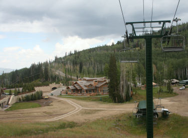
Getting there:
As you drive into Park City, you'll arrive at the "main"
intersection of Park Avenue and Kearns Blvd. From the light, head
south on Park Avenue (straight ahead if you came from I-80, a left
turn if you arrived on Kearns Blvd from US-40). Keep going through town.
Just after the road veers a little to the right, it becomes narrower. As
you reach the end of the homes and pavement, find parking on your left
along the creek. Start the ride by continuing up the dirt road the
direction you were driving. |
|


