 |
Suncrest Loop
(Eagle Crest Trail, Maple Hollow, BST, Clarks)
The Eagle Crest Trail contours the slopes on the southern side of
Traverse Mountain. The trail is 2.5 miles long. East to west,
there's 300 feet of elevation change with total climbing of 500 feet. This
page describes one of many ride options using Eagle Crest, an older route
called the Suncrest Loop, established before many of the newer trails came
to be.
Typical riding scene about half-way
along the loop trail, with low scrub oak along a fairly buff trail
surface. Review by Bruce on September 12, 2008.
|
| The classic loop
described uses Eagle Crest westbound, the Maple Hollow DH
trail down to the bottom, then the Bonneville
Shoreline trail eastbound to Corner Canyon, then Clarks Trail
up to the Peak View trailhead. Then bits of doubletrack to close the gap
between the Peak View trailhead on Traverse Ridge and the eastern end of
Eagle Crest on Suncrest Drive. The loop is 10.1 miles in length, plus
whatever distance you rode to reach the loop -- unless you started at one
of the trailheads on top of the mountain in Suncrest. Your total climbing
will be just over 2000 vertical feet (plus whatever it took to reach the
loop). It's best reserved for the strong and skilled, because Maple Hollow
is designed for expert freeriders and Clarks is a tough unrelenting climb.
If you use Maple Hollow, you MUST do the loop clockwise.
View over Suncrest Drive near the
eastern end of the Eagle Crest trail. We're looking southeast, going
clockwise. |

|
 |
Be sure to obey seasonal trail
closures. Clarks Trail and the Maple Hollow DH trail will be closed in
early spring and late fall when the trail surface is muddy. Because Eagle
Crest is on a south-facing slope, it will often be temptingly free of snow
while Maple Hollow DH and Clarks are still too muddy to ride. Check the
Corner Canyon website for trail closure information.
Typical revegetation area. Grasses are
handlebar high.
|
| On the loop, you'll have wide views over the Salt Lake
Valley while you're on the north side, and views of Utah Valley on the
south. Most of the trail landscape will be scrub oak forest with maples in
the cooler spots. On Eagle Crest, there will be areas of "fill" with handlebar-high
grasses.
These fill areas are replanted steep transition zones from the leveling of
the residential areas on the mountainside above you. In these spots, watch
for weeds winding around your rear cogs and jamming your rear derailleur.
A rider goes airborne near the bottom
of Maple Hollow. |

|
 |
The segments for this ride are:
Eagle Crest east to west: 2.5 miles, 450 vertical feet climbing
Maple Hollow DH: 1.8 miles with 1000 vertical descent
East on Traverse Ridge Rd 100 yards
Bonneville Shoreline eastbound: 2.9 miles, 500 feet of climbing
Clark's Trail: 1.8 miles, 700 feet of climbing
Ann's eastbound: 0.2 miles to Peak View trailhead
Doubletrack southwest to Suncrest Drive: 0.9 miles, 100 vertical
climbing
Downhill 100 yards to Eagle Crest
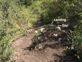
View on the DH trail in the northern
Maple Hollow (there's a Maple Hollow on both sides of the mountain). This
is a gap jump, with a "B-line" route around it. |
| There are
easier options. For example, substituting Ann's
Connector and the western side of Ann's
Trail (and a little bit more of the Bonneville Shoreline) for the
Maple Hollow downhill makes the descent suitable for riders with
intermediate skills. It also allows you to ride the loop counterclockwise,
climbing the western side of Ann's before climbing Ann's Connector up to
Eagle Crest. (Note that if you ride counterclockwise, you can't descend
Clarks! You must substitute Rush, Canyon
Hollow, or Ghost Falls for your
descent.
View eastward on the Bonneville
Shoreline Trail. |

|
 |
And for an easier climb, you can head up Canyon
Hollow and Brock's Point instead of Clarks.
And if you need an alternative that's both shorter and easier, here's a
loop that's just over 8 miles but with less than half the climbing. Ride Ann's
Trail east from the Potato Hill
trailhead, then find your way from the Peak View trailhead (top of
Traverse Ridge) to the east end of Eagle Crest. After riding Eagle Crest
east-to-west to the Elk Glen TH, drop down Ann's
Connector to Ann's Trail and head east back to Potato Hill.
Cruising through a grove of maple. |
| For truly epic rides, most bikers chose to start in the valley. Of
course, there's the equestrian trailhead in Corner Canyon. Other popular
trailheads include Coyote Hollow (close to the start of Clarks Trail), Oak Hollow
(where parking is available at the pool), and Potato Hill.
This is a view up Clarks Trail, which
is the climbing route if you choose to do the 10-mile clockwise classic epic loop. |

|
 |
For a real epic, Utah County riders start in Alpine and
climb Hog Hollow. (You'll climb the mountain twice -- once on each side.) There's no parking lot
where dirt meets pavement, however. You'll need to pick your parking spot, then
ride to the Hog Hollow road. Off-street public parking is available in
Burgess Park (see below). Add 1000 feet of vertical, 3.7 miles of dirt
(each way), and a mile of
city streets for this option. That's 20 miles with 3K climbing.
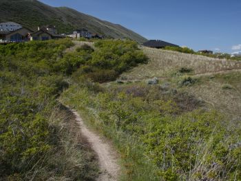
View up the Oak Hollow trail, a
popular route to reach the BST and the epic loop. |
Riding Guide to loop, from Alpine:
0.0 Parking in Burgess Park
Head back (south) to Canyon
Crest
0.1 R on Canyon Crest
0.4 L on Long Drive
0.6 R on Ranch Drive
0.9 Cross Westfield Road onto DT
N40 26.924 W111 47.706
1.1 Fork R
N40 27.017 W111 47.839
1.8 Straight then veer L uphill
N40 27.616 W111 47.866
|
2.2 Rejoin old HH Road, straight
N40 27.904 W111 48.241
4.1
Veer L
N40 28.992 W111 49.300
4.2 L on Corner Canyon Rd
4.3 Fork L (leave old CC road)
N40 28.942 W111 49.573
4.4 Fork R
N40 28.868 W111 49.563
4.5 Suncrest Drive, L downhill
N40 28.760 W111 49.508
4.6 Cross street to ST on R, you're there...
N40 28.688 W111 49.408 |
Epic Loop Clockwise, from Suncrest Drive:
0.0 Uphill southwest from sidewalk
N40 28.688 W111 49.408
Eagle Crest Trail
0.3 Keep L
N40 28.453 W111 49.537
1.3 Parking area, go up road 100 feet
N40 28.326 W111 50.167
Find ST on L
N40 28.453 W111 49.537
1.4 Ride around small pond, L on DT
N40 28.355 W111 50.243
50 feet down, find ST on R
N40 28.350 W111 50.260
2.0 Keep R (L = down Maple Hollow)
N40 28.395 W111 50.721
2.2 Keep L (R = up to road)
N40 28.520 W111 50.823
2.4 R under road, up to Deer Ridge TH
2.5 Find ST trail on L
N40 28.537 W111 51.066
Maple Hollow DH trail
2.8 Cross DT
N40 28.593 W111 51.156
3.0 Go either way (L = to "drop-in")
N40 28.634 W111 51.343 |
4.4 R (straight = old Maple Hollow)
4.7 Traverse Ridge Rd, L (alt=R)
N40 29.081 W111 51.856
Find BST, head east
Bonneville Shoreline
5.5 Cross Mike Wier
N40 29.173 W111 51.657
6.5 Keep uphill (down = Spring Hollow)
7.7 Straight (L = Coyote Hollow)
N40 29.572 W111 50.251
Clarks Trail
9.3 Top of Clarks, R on CC road
N40 29.314 W111 49.218
DT (May change with
development)
9.5 Keep R at Hog Hollow
9.7 Keep R
9.8 Fork L (leave old CC road)
N40 28.942 W111 49.573
9.9 Fork R (toward Suncrest)
N40 28.868 W111 49.563
10.0 L downhill along Suncrest
N40 28.760 W111 49.508
10.1 Cross street to ST on R
N40 28.688 W111 49.408 |
 |
Getting there:
Lower Corner Canyon Trailhead (Equestrian Center):
Take the Bluffdale exit from I-15 and turn east towards the mountains.
Continue on Highland Drive until you reach the ballpark parking lot.
Directly across the street from the parking, the Lower Corner Canyon trail
heads uphill (GPS N 40° 30.351' W 111° 50.721'). To reach the trailhead
from the north (Sandy area), take 13th East southward until it ends at the
stop sign just past the underpass. Turn left and drive 1/4 mile, then turn
left into the paved parking area. Start riding by going under the street
and keeping left on the Corner Canyon Trail, connecting to Ghost Falls,
Canyon Hollow, or Clarks at mile 1.2. (Bathroom at this TH.) |
Deer Ridge (Maple Hollow) trailhead: From I-15
in Salt Lake City, take the Bluffdale exit and head east on Highland Drive
toward the mountains. As you reach the traffic light at the top of the
hill, about 3/4 mile after leaving the freeway, turn right on Traverse
Ridge Road. Drive about two miles up to the top of the mountain. At the
stop sign in Suncrest, turn right on Deer Ridge Drive and go 0.9 miles.
Just before the road crosses a bridge, turn right onto Elk Glen Drive and
immediately turn left to park at the small picnic area. The Suncrest Loop
Trail starts with the cinder path on your left. The Maple Hollow DH trail
is straight ahead and veers to the right toward the Salt Lake valley.
Oak Hollow (pool) trailhead: Exit I-15 as above and
head uphill to the traffic light at the top of the hill. Go straight, then
take the next right turn at Vestry Drive in 0.5 mile. Roll around the
roundabout to go left, then turn into the pool parking. To start the ride,
head back to the roundabout and find the trail on the uphill-southwest
side.
Mike Weir (BST) trailhead: Leave I-15 and climb the hill as above,
but turn right at the light on Traverse Mountain Road. After one mile,
watch for Mike Weir Drive on your left. The trailhead is on your right,
1/2 mile later.
Coyote Hollow (Clarks) trailhead: Take the Bluffdale exit from I-15
and turn east towards the mountains. Climb the hill as above, but turn
right at the light on Traverse Mountain Road. After one mile, turn into
Mike Weir Drive on your left. Pass the Mike Weir trailhead 1/2 mile later
and continue another half mile until the road veers left downhill. Take
the next right turn, turn right again, then left. You should now be on
Gray Fox Drive. Take the next right into Coyote Hollow Court. The parking
is on the right at the end of the pavement.
Burgess Park (Alpine): Head to main street in Alpine. At the
traffic circle, turn left on Canyon Crest Road. When you see the park on
your right, turn and find a parking spot. On your bike, head back to
Canyon Crest, turn left on Long Drive, then right onto the paved bike lane
in front of the homes on Ranch Drive. At the top of Ranch Drive where it
ends on Westfield Road, the trail is just across the street. |
| Getting from Eagle Crest Trail
eastbound to the Peak View Trailhead (top of Rush, Clark's, Brocks) by
bike: The area between Suncrest Drive and the Peak
View TH is still under development, so routes are likely to change. See
our connections page, which will be updated
periodically. |
|


