|

|
|
View southwest overlooking Solitude Resort and Big Cottonwood
Canyon. September 28,
1998 photo by Bruce.
|
 |
The Wasatch Crest Trail runs along the high ridge between Big
Cottonwood Canyon and Park City, then descends via
Mill Creek Canyon. This is a very popular and well-traveled trail. Because
it's at high altitude, the riding season starts in July. There are many
ways to enjoy this great trail.
View from Scott's Bypass trail as you begin
the ride at the top of Guardsman Pass. Original review written in 1998,
with periodic updates. |
Shuttled rides!
Most riders do the Wasatch Crest as a shuttled ride from the top of Big
Cottonwood Canyon. There are two popular starting points from Guardsman
Road. (See below for more detrails.) The lower trail, the Wasatch Crest
Connector doubletrack, climbs to Scott's Pass. The higher Scott's Bypass
singletrack trail descends from higher on the mountain. The two options converge at Scott's Pass below Puke Hill. The shuttled ride ends with a
pavement rush down Mill Creek Canyon (or more dirt Mill
Creek Upper Pipeline and classic lower Pipeline plus Rattlesnake
BST on the way down).
Scott's Bypass trail has varied scenery,
ranging from open meadows to aspen groves to deep fir forest. |
|
 |
Climbing to the Crest!
There are other ways to ride the Crest. Hardbodies can climb from Mill Creek Canyon's Big Water
trail and ride the Wasatch Crest as a 20-mile out-and-back or as a loop
with Midmountain. (Upper
Mill Creek trails are open to bikes only on even-numbered days!) You can
also reach the Crest by climbing Mill D North Fork,
which hooks in above Desolation Lake.
Climbing the Big Water trail in Mill
Creek Canyon. At the top of Mill Creek, we can loop around the Midmountain
Trail then climb to the crest for a giant loop ride. Photo 2012. |
The Crest from Park City!
You can also get there from Park City for an out-and-back or loop. Any
climbing route to Midmountain can get you to
the Wasatch Crest. Pine Cone Ridge connects
directly to Puke Hill at the south end of the Crest. You can reach Scott's
Pass via the Shadow Lake Trail or connect to Scott's Bypass via Dead Tree
(see the Scott's Bypass Loop page). You can
also reach Guardsman Road from Deer Valley.
Heading toward the top of Guardsman
Pass on the Dead Tree Trail, we're looking down at Shadow Lake. |

|
 |
Big Loops!
Hardcore riders combine the Wasatch Crest with the Midmountain
trail for a long loop. There are many variations!
Most riders do a clockwise loop, descending the Crest. At
the northern (lower) end of the Crest, the Crest Connector connects to the
Midmountain Trail just north of Red Pine Lodge of The Canyons. At the
southern end of the Crest, there are several connection routes from
Midmountain of varying difficulty and complexity. The most direct route is
Pine Cone Ridge.
View on the Crest Connector Trail at
the northern end of the Midmountain-Wasatch Crest loop. |
Mill D Loop!
You can do a loop on the Cottonwood side. This is a good option on
odd-numbered days, when Mill Creek is closed to bikes. Park at Reynolds
Flat and bike uphill on the Big Cottonwood Road, then Guardsman Road. Hit
the Crest, then after The Spine drop down the trail to Desolation Lake
Trail to the Mill D North Fork. (Intersection of the Crest with the
Desolation Lake trail is GPS N 40° 39.508' W 111° 35.756'.)Looking
toward the mouth of Big Cottonwood. |

|
The Classic Wasatch Crest ride |
The classic Wasatch Crest ride is a 13-mile shuttled ride
from Guardsman Road to the Big Water trailhead in Mill Creek Canyon.
(Even-numbered days only!) But there are two favorite "classic"
starting points. Note that there is NO roadside parking allowed at
these locations. You either need a drop-off -- such as a commercial
shuttle service -- or you must pedal from the Bonanza Flat parking about a
mile away.
(1) Scott's Bypass. Go all the way to the Guardsman Pass parking lot and take Scott's
Bypass trail. Scott's Bypass is 1.4 miles, descending 200 vertical feet
(with a bit of climbing in the middle). The singletrack ends at Scott's
Pass above Shadow Lake. Because there's room to unload and turn around,
this is the starting point for the commercial shuttles.
A hairpin turn in the aspens on
Scott's Bypass. |

|
 |
(2) Crest Doubletrack Connector. There's a doubletrack located at a turn
in the Guardsman road. The DT climbs uphill 0.8
miles to Scott's Pass. It's a stiff climb, covering about 450 vertical
feet. Note that there is NO parking allowed here -- drop-off only.
No matter which trailhead you select, you've gotta
climb Puke Hill from Scott's Pass to the top of the Crest. This rider is
about finished. |
| At Scott's Pass, take the doubletrack on your left heading
uphill. You're now on the way to Puke Hill, the final brute climb to the
Crest. It's 350 vertical feet in 1/2 mile, with the steepest part at the
highest altitude. The name Puke Hill was not chosen arbitrarily. Take a
break at 9900 feet to enjoy the views.
Looking south from Puke Hill at
Brighton Resort.
|

|
 |
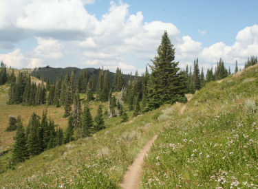
On the ridge there will be singletrack to your right. That's
Pine Cone Ridge. To continue on the Crest, veer left along the ridge on
doubletrack trail. After the second transmission shack, it converts to
single track.
A rider hits a rolling uphill as he
proceeds westbound along the Wasatch Crest.
|
| The trail rolls up and down, with fabulous views of the granite peaks
southward in Big Cottonwood and Little Cottonwood canyons on your left.
Occasionally, you'll see a bit of the Park City area to your right.
View north over the Park City ski
areas, with I-80 heading east in the valley below. On the right, the peaks
of the Uintah Mountains reach the skyline.
|

|
 |
Into late summer, the trail is surrounded by sticky geranium, wild flax,
paintbrush, daisy, wild rose, and arnica. Later in the season, currants, rose hips, and
elderberry provide color as the leaves turn yellow. There's
a fair amount of up-and-down riding as you follow the Wasatch Crest trail
west, then north. |
| Until you drop into north Mill Creek
Canyon, every inch of the trail has a fabulous view extending over miles of alpine
landscape.
Just before turning north away from
Big Cottonwood Canyon, we take a look down the canyon. The Oquirrh
Mountains are across the Salt Lake valley in the distance.
|

|
 |
Above Desolation Lake, the sharp fin of rock called The
Spine is a challenge for the very best
riders. The ridge is a col, a fin left standing between two glaciers as they ate
into the mountain towards each other (there's a glacial cirque and lake on
either side of the fin).
This rider is heading toward the
easier left line on The Spine, while another biker judiciously packs his
bike downhill.
|
| This is a good spot to take a break. Enjoy the views of
Desolation Lake. Hike back uphill and try The Spine again.
Desolation Lake. The Bingham Canyon
copper mine can be seen in the distance.
|

|
 |
Don't be ashamed to walk your bike
over this area. Most riders walk -- or stop for on-trail repairs and bandaging.
Want to ride? The line to the far left is suitable for confident
upper-intermediate riders. The apex of the ridge right on top of the spine
looks scary, but it's a pretty good line. The area between them is a trap.
Taking the ballsy line.
|
| Keep right at the trail fork just below The Spine (left goes
down to Desolation Lake and Mill D North Fork). Now motor on toward Mill
Creek Canyon, stopping occasionally for the views. This section of the
trail (Mill Creek Canyon) is open to mountain bikers on even days only -- you can bike the
28th, but not the 29th.
An optional descent is the Mill Creek
Meadows trail, found 0.5 miles from the Mill D North Fork
intersection. It's an unmarked trail fork 0.1 miles from the transition
between Big Cottonwood and Mill Creek. This trail is 2 miles and shortens
the overall ride by about a mile.
Another peek south at Solitude
Resort's ski slopes.
|

|
 |
Assuming you're still descending the Wasatch Crest above
Mill Creek, keep to the left at the intersection with the
Crest Connector around 2 miles from the Desolation Lake trail fork. Follow the trail signs down Mill Creek Canyon to the Lower Big
Water Trail. (Alternate: shorter steeper descent down Red
Pine Road Trail.) The official ride ends in the parking lot in upper Mill Creek Canyon.
Coast
down the road to your shuttle vehicle.
A rider zooms downhill in upper Mill
Creek Canyon.
|
| A popular option (our personal favorite) is to catch the Upper
Mill Creek Pipeline at Big Water, then link to the lower Pipeline at Elbow
Fork. Ride the Pipeline to Rattlesnake
Gulch, then run out the bottom of the canyon.
Looking west, around the midpoint of
the descent down Mill Creek.
|

|
Riding directions, Classic Crest from
Guardsman Pass:
0.0 From parking, find DT (north uphill)
N40 36.409 W111 33.291
0.1 Veer L onto ST (Scott's Bypass)
1.4 Drop to Scott's Pass
N40 36.992 W111 33.511
Straight across, uphill on DT
(L = down to road, R = Shadow
Lake)
1.9 Puke Hill N40 37.264 W111 33.731
Go L (R = Pine Cone Ridge)
5.8 The Spine N40 39.354 W111 35.708 |
5.9 Keep R (L = Desolation Lake)
N40 39.508 W111 35.756
7.7 View on R N40 40.842 W111 36.144
8.3 Keep L (R = Crest Connector)
N40 41.219 W111 36.083
9.2 Keep L (R = Red Pine Rd Trail)
N40 41.029 W111 36.901
11.3 Straight N40 40.685 W111 38.486
(L = Dog Lake, R = Little
Water)
13 Parking N40 41.082 W111 38.905 |
Getting there:
Guardsman Road drop-off points: Leave a shuttle vehicle below the
mouth of Mill Creek Canyon. (Not in the residential areas, please!) Now
drive to Big
Cottonwood Canyon (Wasatch Blvd and 72nd South). Pass Solitude Resort (at
about
15 miles). Just before you reach Brighton Resort, the road to Guardsman Pass turns off on your
left. At 0.8 miles, you'll see a red metal gate. Exactly one mile later (1.8 miles from
the fork in the road), you'll see a dirt road on the left. GPS N 40° 36.817' W 111°
33.532'. This is the first option to start your ride. Note that parking
along the road is no longer allowed. This is a drop-off only. (There's a second -- closed --
gate about 100 yards up the road. Just pack your bike around the gate and continue.)
Another mile up Guardsman Road, you'll reach the summit. There's a wide area
here at the roadside, but it's not for parking. Again, it's drop-off only. The doubletrack on the north is the trail. Drop off the
doubletrack about 0.1 mile later to start the singletrack Scott's Bypass.
Pine Creek/Bonanza Flat trailhead: On the Guardsman Road two
miles from Guardsman Pass (and about 1/2 mile west of Empire Pass) turn downhill into the trailhead.
From this trailhead, your options are (1) ride two miles west to Guardsman
Pass and Scott's Bypass trail or (2) take Charlie's
9K trail 5 miles to Blazing Saddles to reach Scott's Pass. The connector to the 9K trail is
across the road from parking. It's around 0.7 miles up to the 9K trail,
which you'll find on the opposite side of a doubletrack on the ridge. |
 |
Mill Creek trailhead: Get to Foothill Blvd on the east
bench of Salt Lake City via I-215. Exit at 39th South. Take 3800 South eastbound into the
Canyon. Drive all the way to the top of the canyon. The trail begins on the south end of
the Big Water Trailhead parking area GPS N 40° 40.922' W 111° 34.199'. (Note: the gate
to upper Mill Creek Canyon is open to cars July 1 to November 1. Mountain bikes are only
allowed on upper Mill Creek trails on EVEN numbered days!) The fee to enter
Mill Creek Canyon is $5 per car (2022), payable by charge card on leaving. |
Mill D Loop or climb: Drive up Big Cottonwood Canyon to
Reynold's Flat and the Mill D North Fork trailhead. Shuttle or ride to the trail head. You can bomb down Mill D
North Fork from Desolation Lake, or make the loop around north Mill Creek Canyon
and catch the Dog Lake trail back to Mill D. See the Mill
D North Fork page for loop options from Mill D.
Park City epic loops: For real hammerheads, consider
riding the Wasatch Crest from Park City. Starting spots include Rob's
Trail, The Canyons (Ambush), Park City Mountain Resort (Crescent Mine
Grade, Spiro, Armstrong), Sweeney/Johns, and Deer Valley's Silver Lake
Lodge. Climb to the Wasatch Crest, ride it, then drop back to the Midmountain trail at the fork above
Mill Creek Canyon. See
the Wasatch Crest - Midmountain Loop Trail page.
|
| Above: View from the ridgeline at Desolation Lake.
That's my old Rockhopper. Desolation Lake is a glacial lake, with the rounded valley (called a cirque) carved
out by the weight of moving ice. September
28, 1998. |

Copyright 2000 Mad Scientist Software Inc
Last updated 2012
|


